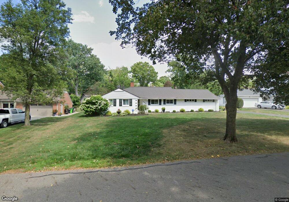
1440 Briarwood Rd Alliance, OH 44601
Estimated Value: $259,292 - $338,000
4
Beds
3
Baths
2,221
Sq Ft
$136/Sq Ft
Est. Value
About This Home
This home is located at 1440 Briarwood Rd, Alliance, OH 44601 and is currently estimated at $302,573, approximately $136 per square foot. 1440 Briarwood Rd is a home located in Stark County with nearby schools including Alliance Early Learning School, Alliance Intermediate School at Northside, and Alliance Middle School.
Ownership History
Date
Name
Owned For
Owner Type
Purchase Details
Closed on
Jun 24, 2024
Sold by
Murray Richard W and Murray Mary J
Bought by
Murray Family Irrevocable Residence Trust and Murray
Current Estimated Value
Purchase Details
Closed on
Jun 21, 2013
Sold by
Baker Jeffrey W
Bought by
Murray Richard W and Murray Mary J
Purchase Details
Closed on
Apr 3, 2000
Sold by
Baker Mary L
Bought by
Baker Mary Louise and Mary Louise Baker Trust
Purchase Details
Closed on
Dec 14, 1999
Sold by
Baker Mary L
Bought by
Baker Mary Louise and Mary Louise Baker Trust
Create a Home Valuation Report for This Property
The Home Valuation Report is an in-depth analysis detailing your home's value as well as a comparison with similar homes in the area
Home Values in the Area
Average Home Value in this Area
Purchase History
| Date | Buyer | Sale Price | Title Company |
|---|---|---|---|
| Murray Family Irrevocable Residence Trust | -- | None Listed On Document | |
| Murray Richard W | $140,000 | None Available | |
| Baker Mary Louise | -- | -- | |
| Baker Mary Louise | -- | -- |
Source: Public Records
Tax History
| Year | Tax Paid | Tax Assessment Tax Assessment Total Assessment is a certain percentage of the fair market value that is determined by local assessors to be the total taxable value of land and additions on the property. | Land | Improvement |
|---|---|---|---|---|
| 2025 | -- | $77,490 | $20,230 | $57,260 |
| 2024 | -- | $77,490 | $20,230 | $57,260 |
| 2023 | $2,212 | $64,230 | $15,260 | $48,970 |
| 2022 | $1,346 | $64,230 | $15,260 | $48,970 |
| 2021 | $1,409 | $64,230 | $15,260 | $48,970 |
| 2020 | $1,994 | $54,750 | $13,270 | $41,480 |
| 2019 | $382 | $54,750 | $13,270 | $41,480 |
Source: Public Records
Map
Nearby Homes
- 1539 Parkway Blvd
- 1038 Vincent Blvd
- 1073 Parkside Dr
- 1156 Parkside Dr
- 2144 Ridgewood Ave
- 1534 Fernwood Blvd
- 1134 Glamorgan St
- 1718 Fernwood Blvd
- 807 S Union Ave
- 134 11th St
- 225 Shadyside Ct
- 1310 Overlook Dr
- 167 11th St
- 621 S Haines Ave
- 535 S Mckinley Ave
- 233 W Cambridge St
- 1114 Briarcliff Ave
- 430 W Oxford St
- 2135 Cherry Ave
- 228 W Oxford St
- 1456 Briarwood Rd
- 1422 Briarwood Rd
- 1435 Robinwood Rd
- 1445 Robinwood Rd
- 1425 Robinwood Rd
- 1457 Robinwood Rd
- 1472 Briarwood Rd
- 1409 Robinwood Rd
- 1435 Briarwood Rd
- 1449 Briarwood Rd
- 638 Overlook Dr
- 1415 Briarwood Rd
- 1469 Robinwood Rd
- 1469 Briarwood Rd
- 1488 Briarwood Rd
- 622 Overlook Dr
- 708 Overlook Dr
- 1483 Robinwood Rd
- 1485 Briarwood Rd
- 730 Overlook Dr
Your Personal Tour Guide
Ask me questions while you tour the home.