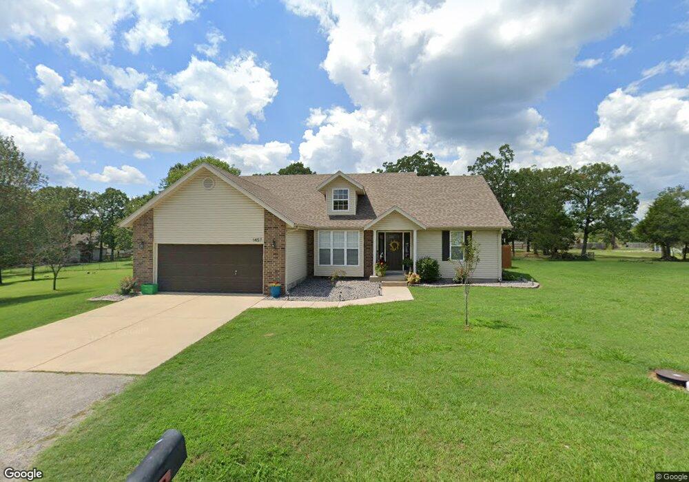
1457 Bird Rd Branson, MO 65616
North Branson NeighborhoodEstimated Value: $351,547 - $396,000
4
Beds
3
Baths
2,599
Sq Ft
$142/Sq Ft
Est. Value
About This Home
This home is located at 1457 Bird Rd, Branson, MO 65616 and is currently estimated at $368,637, approximately $141 per square foot. 1457 Bird Rd is a home located in Taney County with nearby schools including Cedar Ridge Primary, Cedar Ridge Intermediate School, and Cedar Ridge Elementary School.
Ownership History
Date
Name
Owned For
Owner Type
Purchase Details
Closed on
Dec 2, 2020
Sold by
Willard Curtis and Willard Denise
Bought by
Miller Mark and Miller Erin
Current Estimated Value
Home Financials for this Owner
Home Financials are based on the most recent Mortgage that was taken out on this home.
Original Mortgage
$60,000
Outstanding Balance
$43,031
Interest Rate
2.8%
Mortgage Type
New Conventional
Estimated Equity
$325,606
Purchase Details
Closed on
Jun 29, 2007
Sold by
Willard Curtis and Willard Denise
Bought by
Willard Curtis and Willard Denise
Create a Home Valuation Report for This Property
The Home Valuation Report is an in-depth analysis detailing your home's value as well as a comparison with similar homes in the area
Home Values in the Area
Average Home Value in this Area
Purchase History
| Date | Buyer | Sale Price | Title Company |
|---|---|---|---|
| Miller Mark | -- | None Available | |
| Willard Curtis | -- | -- |
Source: Public Records
Mortgage History
| Date | Status | Borrower | Loan Amount |
|---|---|---|---|
| Open | Miller Mark | $60,000 |
Source: Public Records
Tax History
| Year | Tax Paid | Tax Assessment Tax Assessment Total Assessment is a certain percentage of the fair market value that is determined by local assessors to be the total taxable value of land and additions on the property. | Land | Improvement |
|---|---|---|---|---|
| 2025 | $1,496 | $25,520 | -- | -- |
| 2023 | $1,496 | $27,980 | $0 | $0 |
| 2022 | $1,455 | $27,980 | $0 | $0 |
| 2021 | $1,445 | $27,980 | $0 | $0 |
| 2019 | $1,245 | $23,100 | $0 | $0 |
| 2018 | $1,297 | $24,050 | $0 | $0 |
| 2017 | $1,171 | $21,910 | $0 | $0 |
| 2016 | $1,168 | $21,910 | $0 | $0 |
| 2015 | $1,157 | $21,910 | $0 | $0 |
| 2014 | $960 | $19,070 | $0 | $0 |
Source: Public Records
Map
Nearby Homes
- 119 Carmen Ln
- 153 Sapling Dr
- 146 Sapling Dr
- 229 Stillwood Dr Unit 6a
- 301 Stillwood Dr
- 311 Stillwood Dr
- 328 Sunny Brook Dr
- 160 Brookside Ct
- 142 Rue de Villas Cir
- 152 Rue de Villas Cir Unit 4
- 110 Stone Cir
- 125 Lakehills Dr Unit B
- 210 Rue de Villas Cir
- 155 Rue de Villas Cir
- 134 Vixen Cir Unit G
- 160 Rue de Villas Cir
- 127 Vixen Cir Unit K
- 288 Eagle Rock Rd
- 118 Vixen Cir Unit D
- 126 Rue de Villas Cir
- 1453 Bird Rd
- 1449 Bird Rd
- 768 Hummingbird Ln
- 742 Hummingbird Ln
- 15 Sapling Dr
- 22 Sapling Dr
- 3 Sapling Dr
- 10 Sapling Dr
- 100 Acorn Ln
- 102 Acorn Ln
- 100 Sapling Dr
- 104 Acorn Ln
- 770 Hummingbird Ln
- 730 Hummingbird Ln
- 106 Acorn Ln
- 102 Sapling Dr
- 108 Acorn Ln
- 101 Sapling Dr
- 104 Sapling Dr
- 104 Sapling Dr Unit T
Your Personal Tour Guide
Ask me questions while you tour the home.