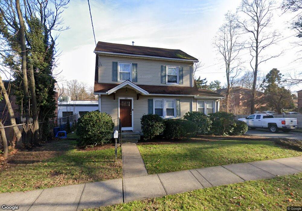
1486 E Broad St Westfield, NJ 07090
Estimated Value: $723,740 - $952,000
Studio
--
Bath
1,360
Sq Ft
$630/Sq Ft
Est. Value
About This Home
This home is located at 1486 E Broad St, Westfield, NJ 07090 and is currently estimated at $856,935, approximately $630 per square foot. 1486 E Broad St is a home with nearby schools including Washington Elementary School, Edison Intermediate School, and Westfield Senior High School.
Ownership History
Date
Name
Owned For
Owner Type
Purchase Details
Closed on
Apr 9, 2022
Sold by
Brinton John F
Bought by
1486 East Broad St Llc
Current Estimated Value
Purchase Details
Closed on
Feb 22, 1999
Sold by
Dipaolo Lorraine and Dipaolo Nicholas
Bought by
Brinton John F
Home Financials for this Owner
Home Financials are based on the most recent Mortgage that was taken out on this home.
Original Mortgage
$91,000
Interest Rate
6.76%
Mortgage Type
Stand Alone First
Create a Home Valuation Report for This Property
The Home Valuation Report is an in-depth analysis detailing your home's value as well as a comparison with similar homes in the area
Home Values in the Area
Average Home Value in this Area
Purchase History
| Date | Buyer | Sale Price | Title Company |
|---|---|---|---|
| 1486 East Broad St Llc | -- | Beinhaker Mitchell C | |
| Brinton John F | $130,000 | -- |
Source: Public Records
Mortgage History
| Date | Status | Borrower | Loan Amount |
|---|---|---|---|
| Previous Owner | Brinton John F | $91,000 |
Source: Public Records
Tax History
| Year | Tax Paid | Tax Assessment Tax Assessment Total Assessment is a certain percentage of the fair market value that is determined by local assessors to be the total taxable value of land and additions on the property. | Land | Improvement |
|---|---|---|---|---|
| 2025 | $10,713 | $475,700 | $347,000 | $128,700 |
| 2024 | $10,494 | $475,700 | $347,000 | $128,700 |
| 2023 | $10,494 | $475,700 | $347,000 | $128,700 |
| 2022 | $10,275 | $475,700 | $347,000 | $128,700 |
| 2021 | $10,289 | $475,700 | $347,000 | $128,700 |
| 2020 | $10,266 | $475,700 | $347,000 | $128,700 |
| 2019 | $10,228 | $475,700 | $347,000 | $128,700 |
| 2018 | $9,000 | $96,800 | $46,300 | $50,500 |
| 2017 | $8,950 | $96,800 | $46,300 | $50,500 |
| 2016 | $8,740 | $96,800 | $46,300 | $50,500 |
| 2015 | $8,566 | $96,800 | $46,300 | $50,500 |
| 2014 | $8,283 | $96,800 | $46,300 | $50,500 |
Source: Public Records
Map
Nearby Homes
- 58a Sandra Cir Unit A2
- 52b Sandra Cir Unit 2B
- 46 B Sandra Cir Unit 4
- 1351 E Broad St
- 19 Carol Rd
- 29 Manitou Cir
- 37 A3 Sandra Cir
- 21 Sandra Cir
- 42 Nomahegan Ct
- 9 Settlers Ln
- 941 Harding St
- 820 E Broad St
- 1008 Cranford Ave
- 603 Brookside Place
- 208 Jefferson Ave
- 312 Wells St
- 735 Castleman Dr
- 808 Grant Ave
- 440 Orchard St
- 5 Epping Dr
- 57a Sandra Cir Unit B1
- 1481 E Broad St
- 58 C2 Sandra Cir Unit C2
- 1424 E Broad St
- 351 Springfield Ave Unit FL 1
- 351 Springfield Ave
- 351 Springfield Ave Unit FL 2
- 351 Springfield Ave
- 56 C-1 Sandra Cir Unit 1
- 1472 E Broad St
- 400 Springfield Ave
- 56 B Sandra Cir Unit B
- 53 C Sandra Cir
- 364 Springfield Ave
- 41 Nomahegan Dr
- 410 Springfield Ave
- 54c Sandra Cir Unit 4
- 54c Sandra Cir
- 1468 E Broad St
- 360 Springfield Ave
Your Personal Tour Guide
Ask me questions while you tour the home.