Estimated Value: $700,000 - $773,000
3
Beds
2
Baths
1,636
Sq Ft
$446/Sq Ft
Est. Value
About This Home
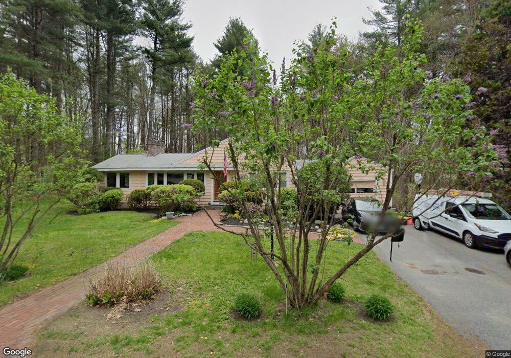
This home is located at 15 Agawam Rd, Acton, MA 01720 and is currently estimated at $729,530, approximately $445 per square foot. 15 Agawam Rd is a home located in Middlesex County with nearby schools including Acton-Boxborough Regional High School.
Ownership History
Date
Name
Owned For
Owner Type
Purchase Details
Closed on
Jun 19, 1998
Sold by
Whalen Donna B
Bought by
Danzig Joseph and Danzig Nele
Current Estimated Value
Home Financials for this Owner
Home Financials are based on the most recent Mortgage that was taken out on this home.
Original Mortgage
$203,850
Outstanding Balance
$40,923
Interest Rate
7.09%
Mortgage Type
Purchase Money Mortgage
Estimated Equity
$688,607
Create a Home Valuation Report for This Property
The Home Valuation Report is an in-depth analysis detailing your home's value as well as a comparison with similar homes in the area
Home Values in the Area
Average Home Value in this Area
Purchase History
We collect this data history from publicly available records. To have your information removed, we recommend requesting removal directly through your county’s website.
| Date | Buyer | Sale Price | Title Company |
|---|---|---|---|
| Danzig Joseph | $226,500 | -- |
Source: Public Records
Mortgage History
We collect this data history from publicly available records. To have your information removed, we recommend requesting removal directly through your county’s website.
| Date | Status | Borrower | Loan Amount |
|---|---|---|---|
| Open | Danzig Joseph | $203,850 | |
| Previous Owner | Danzig Joseph | $132,500 | |
| Previous Owner | Danzig Joseph | $43,000 |
Source: Public Records
Tax History
| Year | Tax Paid | Tax Assessment Tax Assessment Total Assessment is a certain percentage of the fair market value that is determined by local assessors to be the total taxable value of land and additions on the property. | Land | Improvement |
|---|---|---|---|---|
| 2025 | $10,058 | $586,500 | $323,900 | $262,600 |
| 2024 | $9,575 | $574,400 | $323,900 | $250,500 |
| 2023 | $9,143 | $520,700 | $294,400 | $226,300 |
| 2022 | $9,206 | $473,300 | $256,100 | $217,200 |
| 2021 | $8,794 | $434,700 | $237,000 | $197,700 |
| 2020 | $8,258 | $429,200 | $237,000 | $192,200 |
| 2019 | $7,893 | $407,500 | $237,000 | $170,500 |
| 2018 | $7,417 | $382,700 | $237,000 | $145,700 |
| 2017 | $7,294 | $382,700 | $237,000 | $145,700 |
| 2016 | $7,013 | $364,700 | $237,000 | $127,700 |
| 2015 | $6,980 | $366,400 | $237,000 | $129,400 |
| 2014 | $7,018 | $360,800 | $237,000 | $123,800 |
Source: Public Records
Map
Nearby Homes
- 12 Kennedy Ln
- 40 Mohawk Dr
- 31 Elm St
- 23 Spruce St Unit B
- 220 Newtown Rd
- 159 Prospect St Unit 4
- 103 Newtown Rd
- 320 Nagog Hill Rd
- 4 Meadowbrook Rd
- 92 Willow St Unit 1
- 94 Willow St Unit 2
- 315 Nagog Hill Rd
- 20 Pine Pasture Run
- 491 Main St
- 37 Concord Rd
- 524 Main St
- 14 Minot Ave
- 11 Bromfield Rd
- 30 Duggan Rd
- 148 School St
Your Personal Tour Guide
Ask me questions while you tour the home.