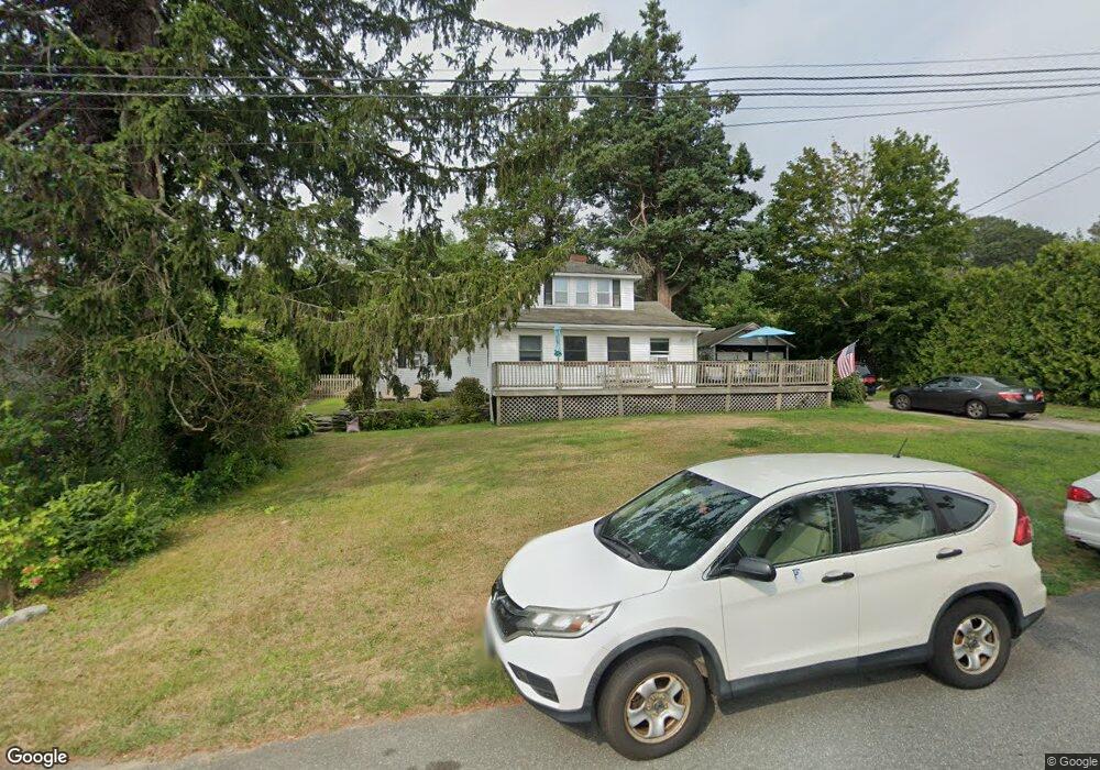
15 Curtis Rd Saunderstown, RI 02874
Saunderstown NeighborhoodEstimated Value: $748,000 - $996,000
4
Beds
3
Baths
2,902
Sq Ft
$296/Sq Ft
Est. Value
About This Home
This home is located at 15 Curtis Rd, Saunderstown, RI 02874 and is currently estimated at $859,359, approximately $296 per square foot. 15 Curtis Rd is a home located in Washington County with nearby schools including Hamilton Elementary School, Wickford Middle School, and North Kingstown Sr. High School.
Ownership History
Date
Name
Owned For
Owner Type
Purchase Details
Closed on
Aug 7, 1984
Bought by
Lonergan Gary David
Current Estimated Value
Create a Home Valuation Report for This Property
The Home Valuation Report is an in-depth analysis detailing your home's value as well as a comparison with similar homes in the area
Home Values in the Area
Average Home Value in this Area
Purchase History
We collect this data history from publicly available records. To have your information removed, we recommend requesting removal directly through your county’s website.
| Date | Buyer | Sale Price | Title Company |
|---|---|---|---|
| Lonergan Gary David | $85,000 | -- |
Source: Public Records
Mortgage History
We collect this data history from publicly available records. To have your information removed, we recommend requesting removal directly through your county’s website.
| Date | Status | Borrower | Loan Amount |
|---|---|---|---|
| Open | Lonergan Gary David | $100,000 | |
| Closed | Lonergan Gary David | $55,000 |
Source: Public Records
Tax History
| Year | Tax Paid | Tax Assessment Tax Assessment Total Assessment is a certain percentage of the fair market value that is determined by local assessors to be the total taxable value of land and additions on the property. | Land | Improvement |
|---|---|---|---|---|
| 2025 | $8,134 | $736,800 | $493,600 | $243,200 |
| 2024 | $7,676 | $535,300 | $345,400 | $189,900 |
| 2023 | $7,676 | $535,300 | $345,400 | $189,900 |
| 2022 | $7,526 | $535,300 | $345,400 | $189,900 |
| 2021 | $6,542 | $373,800 | $219,300 | $154,500 |
| 2020 | $6,388 | $373,800 | $219,300 | $154,500 |
| 2019 | $6,388 | $373,800 | $219,300 | $154,500 |
| 2018 | $6,770 | $356,900 | $239,800 | $117,100 |
| 2017 | $6,635 | $356,900 | $239,800 | $117,100 |
| 2016 | $6,446 | $356,900 | $239,800 | $117,100 |
| 2015 | $6,207 | $321,600 | $222,700 | $98,900 |
| 2014 | $6,081 | $321,600 | $222,700 | $98,900 |
Source: Public Records
Map
Nearby Homes
- 40 Fleetwood Dr
- 100 Snuff Mill Rd
- 16 Triton Dr
- 94 Spindrift St
- 11 Parsley Ln
- 9 Parsley Ln
- 7 Winterberry Rd
- 2 Scull St
- 2180 Tower Hill Rd
- 13 Starboard Ave
- 19 Sea Ridge Dr
- 40 Web Ave Unit 217
- 40 Web Ave Unit 11
- 63 Buoy St
- 11 Johnson Ave
- 0 Meadow Sweet Trail
- 26 Meadow Sweet Trail
- 110 Sea View Ave
- 5 Buoy St
- 8 Sweet Fern Trail
- 23 Curtis Rd
- 5 Curtis Rd
- 20 Curtis Rd
- 18 Curtis Rd
- 30 Curtis Rd
- 121 Harbor View Ave
- 35 Curtis Rd
- 110 Hillside St
- 110 Hill Side St
- 170 Champlin Rd
- 114 Spring St
- 55 Wilbur Hazard Rd
- 101 Tefft St
- 98 Hill Side St
- 73 Wilbur Hazard Rd
- 180 Champlin Rd
- 101 Hill Side St
- 100 Top Hill Rd
- 80 Hillside St
- 80 Hill Side St
Your Personal Tour Guide
Ask me questions while you tour the home.