
Seller's Agent in 2025
Kim Rock
Keller Williams Real Estate-Langhorne
(215) 740-5643
1 in this area
396 Total Sales
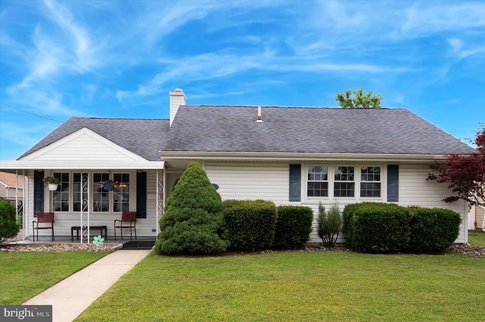
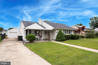
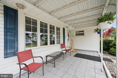
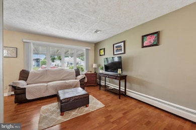
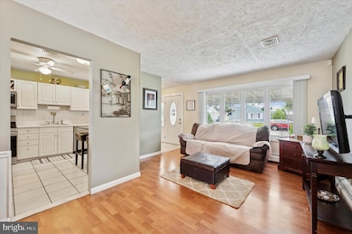
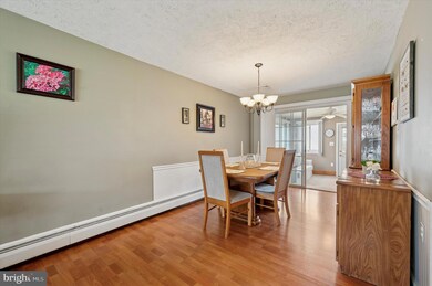
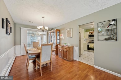
Price improvement after buyer's financing fell through. Proudly presenting this beautifully maintained 3-bedroom, 1-bathroom ranch-style home on a well groomed street in the Alden Park neighborhood of Maple Shade. With over 1,500 square feet of thoughtfully designed living space, this home offers a perfect blend of comfort, character, and functionality. From the moment you arrive, you'll notice the inviting curb appeal and covered front porch floored with tile—an ideal spot to enjoy your morning coffee or unwind in the evening. Inside, you're welcomed by a warm living room that flows seamlessly into the formal dining area—perfect for family gatherings and entertaining. The upgraded kitchen showcases a large convenient walk-in butler's pantry for extra storage. Just beyond, the spacious but cozy family room with a gas fireplace which creates the perfect setting for relaxing nights in. As an added bonus, the home includes an additional room providing even more space for hosting or everyday living. The primary bedroom features an oversized closet, while two additional generously sized bedrooms offer flexibility for guests, family, or a home office. A large laundry room can double as a multifunctional space, ideal for extra storage, crafting, or even a dedicated workspace. Step outside to a beautifully manicured backyard including a detached one-car garage (with electric) and a storage shed—perfect for hobbies, tools, or seasonal items. Whether you're entertaining, gardening, or simply enjoying the outdoors, this yard offers endless possibilities. This move-in-ready rancher is truly one of a kind. Don’t miss your chance to own this gem—schedule your private showing today and experience all that 15 Paul Road has to offer!
Last Agent to Sell the Property
(215) 757-6100 klrw476@kw.com Keller Williams Real Estate-Langhorne License #0999803 Listed on: 06/21/2025
Co-Listed By
(215) 757-6100 klrw476@kw.com Keller Williams Real Estate-Langhorne License #2294768
| Date | Type | Sale Price | Title Company |
|---|---|---|---|
| Bargain Sale Deed | $365,000 | Surety Title | |
| Bargain Sale Deed | $365,000 | Surety Title | |
| Interfamily Deed Transfer | -- | -- | |
| Bargain Sale Deed | $100,000 | Congress Title Corp |
| Date | Status | Loan Amount | Loan Type |
|---|---|---|---|
| Open | $85,000 | New Conventional | |
| Closed | $85,000 | New Conventional | |
| Previous Owner | $115,000 | Fannie Mae Freddie Mac | |
| Previous Owner | $60,000 | Stand Alone First |
| Date | Event | Price | List to Sale | Price per Sq Ft |
|---|---|---|---|---|
| 08/15/2025 08/15/25 | Sold | $365,000 | 0.0% | $242 / Sq Ft |
| 07/07/2025 07/07/25 | Pending | -- | -- | -- |
| 07/03/2025 07/03/25 | Price Changed | $365,000 | -2.7% | $242 / Sq Ft |
| 06/21/2025 06/21/25 | For Sale | $375,000 | -- | $248 / Sq Ft |
| Year | Tax Paid | Tax Assessment Tax Assessment Total Assessment is a certain percentage of the fair market value that is determined by local assessors to be the total taxable value of land and additions on the property. | Land | Improvement |
|---|---|---|---|---|
| 2025 | $7,011 | $184,700 | $48,700 | $136,000 |
| 2024 | $6,808 | $184,700 | $48,700 | $136,000 |
| 2023 | $6,808 | $184,700 | $48,700 | $136,000 |
| 2022 | $6,703 | $184,700 | $48,700 | $136,000 |
| 2021 | $6,638 | $184,700 | $48,700 | $136,000 |
| 2020 | $6,657 | $184,700 | $48,700 | $136,000 |
| 2019 | $6,413 | $184,700 | $48,700 | $136,000 |
| 2018 | $6,302 | $184,700 | $48,700 | $136,000 |
| 2017 | $6,228 | $184,700 | $48,700 | $136,000 |
| 2016 | $6,136 | $184,700 | $48,700 | $136,000 |
| 2015 | $6,003 | $184,700 | $48,700 | $136,000 |
| 2014 | $5,820 | $184,700 | $48,700 | $136,000 |
Seller's Agent in 2025
Kim Rock
Keller Williams Real Estate-Langhorne
(215) 740-5643
1 in this area
396 Total Sales
Seller Co-Listing Agent in 2025
Marc Burick
Keller Williams Real Estate-Langhorne
(215) 350-5634
2 in this area
33 Total Sales
Buyer's Agent in 2025
Eli Qarkaxhia
Compass RE
(215) 731-4116
1 in this area
847 Total Sales
Buyer Co-Listing Agent in 2025
James Roth
Compass New Jersey, LLC - Haddon Township
(609) 828-2458
2 in this area
19 Total Sales
Source: Bright MLS
MLS Number: NJBL2089376
APN: 19-00129-08-00030
Disclaimer: Certain information contained herein is derived from information provided by parties other than Homes.com. All information provided is deemed reliable, but is not guaranteed to be accurate and should be independently verified.
![]() The data relating to real estate for sale on this website appears in part through the BRIGHT Internet Data Exchange program, a voluntary cooperative exchange of property listing data between licensed real estate brokerage firms, and is provided by BRIGHT through a licensing agreement.
The data relating to real estate for sale on this website appears in part through the BRIGHT Internet Data Exchange program, a voluntary cooperative exchange of property listing data between licensed real estate brokerage firms, and is provided by BRIGHT through a licensing agreement.
Listing information is from various brokers who participate in the Bright MLS IDX program and not all listings may be visible on the site.
The property information being provided on or through the website is for the personal, non-commercial use of consumers and such information may not be used for any purpose other than to identify prospective properties consumers may be interested in purchasing.
Some properties which appear for sale on the website may no longer be available because they are for instance, under contract, sold or are no longer being offered for sale.
Property information displayed is deemed reliable but is not guaranteed.
Copyright 2026 Bright MLS, Inc.
Ask me questions while you tour the home.