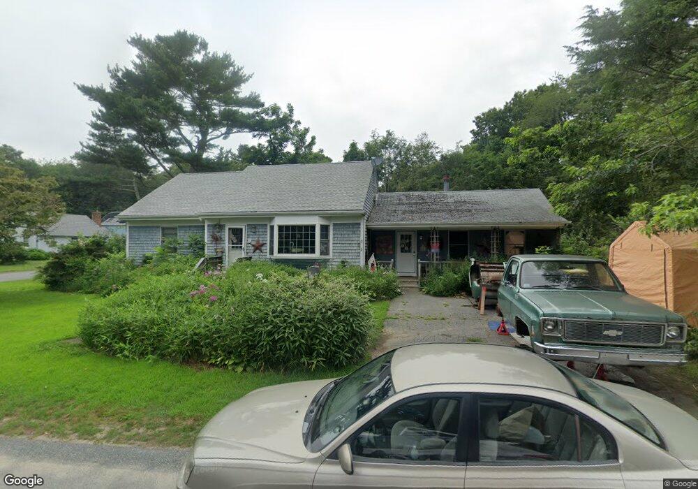
15 Pine St Acushnet, MA 02743
Sherwood Forest NeighborhoodEstimated Value: $481,599 - $604,000
Studio
1
Bath
2,182
Sq Ft
$246/Sq Ft
Est. Value
About This Home
This home is located at 15 Pine St, Acushnet, MA 02743 and is currently estimated at $535,900, approximately $245 per square foot. 15 Pine St is a home located in Bristol County with nearby schools including Acushnet Elementary School, Albert F Ford Middle School, and St Francis Xavier Elementary School.
Ownership History
Date
Name
Owned For
Owner Type
Purchase Details
Closed on
Jun 24, 2022
Sold by
Reynolds Karin
Bought by
Reynolds Karin
Current Estimated Value
Purchase Details
Closed on
Jun 30, 2015
Sold by
Perzentz Gail
Bought by
Perzentz Gail E and Goulart Karin
Purchase Details
Closed on
May 23, 1985
Bought by
Perzentz Gail E and Goulart Karin
Create a Home Valuation Report for This Property
The Home Valuation Report is an in-depth analysis detailing your home's value as well as a comparison with similar homes in the area
Home Values in the Area
Average Home Value in this Area
Purchase History
| Date | Buyer | Sale Price | Title Company |
|---|---|---|---|
| Reynolds Karin | -- | None Available | |
| Perzentz Gail E | -- | -- | |
| Perzentz Gail E | -- | -- |
Source: Public Records
Mortgage History
| Date | Status | Borrower | Loan Amount |
|---|---|---|---|
| Previous Owner | Perzentz Gail E | $35,000 |
Source: Public Records
Tax History
| Year | Tax Paid | Tax Assessment Tax Assessment Total Assessment is a certain percentage of the fair market value that is determined by local assessors to be the total taxable value of land and additions on the property. | Land | Improvement |
|---|---|---|---|---|
| 2025 | $43 | $397,000 | $126,100 | $270,900 |
| 2024 | $4,202 | $368,300 | $119,500 | $248,800 |
| 2023 | $4,242 | $353,500 | $108,400 | $245,100 |
| 2022 | $4,188 | $315,600 | $101,800 | $213,800 |
| 2021 | $3,903 | $282,200 | $101,800 | $180,400 |
| 2020 | $3,840 | $275,500 | $95,100 | $180,400 |
| 2019 | $3,660 | $258,100 | $90,700 | $167,400 |
| 2018 | $3,540 | $245,500 | $90,700 | $154,800 |
| 2017 | $3,440 | $238,200 | $90,700 | $147,500 |
| 2016 | $3,477 | $239,300 | $90,700 | $148,600 |
| 2015 | $3,193 | $223,600 | $90,700 | $132,900 |
Source: Public Records
Map
Nearby Homes
- 1015 Forbes St
- ES Acushnet Ave
- 40 Foley Dr
- 941 Bartlett St
- 953 Phillips Rd
- 1044 Phillips Rd Unit 20
- 23 Coury Dr
- 1044 Victoria St Unit B-29
- 35 Avery St
- 0 Church Dutton & Chaffee Unit 73371719
- 1251 Church St Unit 10
- 1261 Church St Unit 70
- 1261 Church St Unit 53
- 1261 Church St Unit 85
- 1261 Church St Unit 46
- 79 Park Dr
- 765 Pine Hill Dr
- 1164 Victoria St
- 37 Maxine St
- 6 Middlefield Place
Your Personal Tour Guide
Ask me questions while you tour the home.