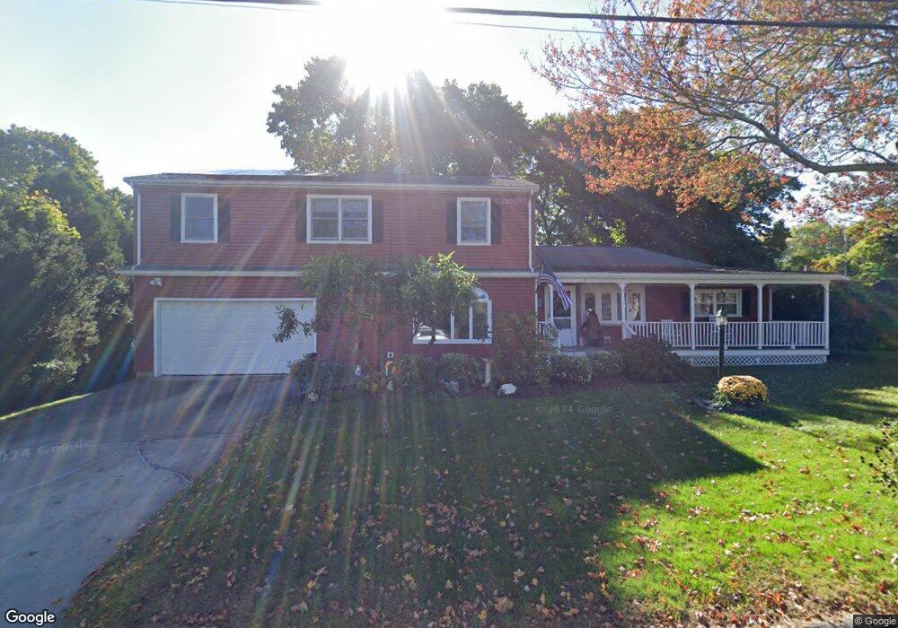
15 Porter St Quaker Hill, CT 06375
Estimated Value: $417,202 - $507,000
4
Beds
2
Baths
2,616
Sq Ft
$177/Sq Ft
Est. Value
About This Home
This home is located at 15 Porter St, Quaker Hill, CT 06375 and is currently estimated at $462,301, approximately $176 per square foot. 15 Porter St is a home located in New London County with nearby schools including Clark Lane Middle School, Waterford High School, and The Williams School.
Ownership History
Date
Name
Owned For
Owner Type
Purchase Details
Closed on
Apr 1, 2025
Sold by
Abbiati George P and Abbiati Thecla C
Bought by
Abbiati T T and Abbiati A
Current Estimated Value
Purchase Details
Closed on
Sep 3, 2010
Sold by
Abbiati George P
Bought by
Abbiati George P and Abbiati Thecla
Purchase Details
Closed on
Jul 29, 1983
Bought by
Abbiati George P and Abbiati Thecia
Create a Home Valuation Report for This Property
The Home Valuation Report is an in-depth analysis detailing your home's value as well as a comparison with similar homes in the area
Home Values in the Area
Average Home Value in this Area
Purchase History
| Date | Buyer | Sale Price | Title Company |
|---|---|---|---|
| Abbiati T T | -- | None Available | |
| Abbiati George P | -- | None Available | |
| Abbiati George P | -- | -- | |
| Abbiati George P | -- | -- |
Source: Public Records
Mortgage History
| Date | Status | Borrower | Loan Amount |
|---|---|---|---|
| Previous Owner | Abbiati George P | $6,000 | |
| Previous Owner | Abbiati George P | $38,900 |
Source: Public Records
Tax History
| Year | Tax Paid | Tax Assessment Tax Assessment Total Assessment is a certain percentage of the fair market value that is determined by local assessors to be the total taxable value of land and additions on the property. | Land | Improvement |
|---|---|---|---|---|
| 2025 | $5,119 | $219,150 | $63,230 | $155,920 |
| 2024 | $4,887 | $219,150 | $63,230 | $155,920 |
| 2023 | $4,646 | $219,150 | $63,230 | $155,920 |
| 2022 | $4,493 | $163,040 | $45,150 | $117,890 |
| 2021 | $4,506 | $163,040 | $45,150 | $117,890 |
| 2020 | $4,544 | $163,040 | $45,150 | $117,890 |
| 2019 | $4,562 | $163,040 | $45,150 | $117,890 |
| 2018 | $4,471 | $163,040 | $45,150 | $117,890 |
| 2017 | $4,694 | $173,670 | $40,130 | $133,540 |
| 2016 | $4,651 | $173,670 | $40,130 | $133,540 |
| 2015 | $4,486 | $173,670 | $40,130 | $133,540 |
| 2014 | $4,486 | $173,670 | $40,130 | $133,540 |
Source: Public Records
Map
Nearby Homes
- 11 Mamacoke Rd
- 448 Mohegan Avenue Pkwy
- 101 Old Norwich Rd
- 153 Old Norwich Rd
- 593 Mohegan Avenue Pkwy
- 118 Bloomingdale Rd
- 322 Virgo Dr
- 31 Pegasus Dr
- 274 Virgo Dr
- 435 Military Hwy Unit 449
- 1323 Baldwin Hill Rd
- 125 Murphys Dr Unit 125
- 23 Skyview Terrace
- 0 Briar Hill Rd Unit 24148389
- 72 Inchcliffe Dr
- 30 Margaret St
- 1010 Long Cove Rd Unit LOT 17
- 20 Inchcliffe Dr
- 171 Norwood Ave
- 40 Kenyon Rd
Your Personal Tour Guide
Ask me questions while you tour the home.