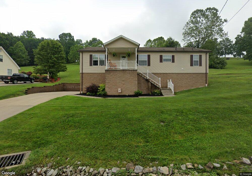
15 Robin Ln Mount Clare, WV 26408
Estimated Value: $318,000 - $332,000
3
Beds
2
Baths
1,546
Sq Ft
$211/Sq Ft
Est. Value
About This Home
This home is located at 15 Robin Ln, Mount Clare, WV 26408 and is currently estimated at $326,542, approximately $211 per square foot. 15 Robin Ln is a home located in Harrison County.
Ownership History
Date
Name
Owned For
Owner Type
Purchase Details
Closed on
Oct 20, 2025
Sold by
Kesselman Candice Nicole and Rush Derrik Lee
Bought by
Dove Dylan James and Dove Naomi Rose
Current Estimated Value
Home Financials for this Owner
Home Financials are based on the most recent Mortgage that was taken out on this home.
Original Mortgage
$296,662
Outstanding Balance
$296,662
Interest Rate
6.35%
Mortgage Type
New Conventional
Estimated Equity
$29,880
Purchase Details
Closed on
May 8, 2021
Sold by
Baker Stefan Paul and Baker Danielle Marie
Bought by
Baker Stefan Paul and Baker Danielle Marie
Purchase Details
Closed on
Oct 14, 2016
Sold by
L & J Dev Llc
Bought by
Baker Stefan Paul
Purchase Details
Closed on
Dec 2, 2013
Sold by
Phillips Edward Raymond
Bought by
Barker Sefan Paul
Home Financials for this Owner
Home Financials are based on the most recent Mortgage that was taken out on this home.
Original Mortgage
$161,000
Interest Rate
4.35%
Mortgage Type
New Conventional
Purchase Details
Closed on
Jun 16, 2008
Sold by
Brunetti Mumford Tina N and Mumford Joe L
Bought by
Phillips Ii Edward Raymond
Home Financials for this Owner
Home Financials are based on the most recent Mortgage that was taken out on this home.
Original Mortgage
$157,600
Interest Rate
6.13%
Mortgage Type
New Conventional
Purchase Details
Closed on
Apr 26, 2007
Sold by
D Nelson Llc
Bought by
Mumford Joel L and Brunetti Tina N
Home Financials for this Owner
Home Financials are based on the most recent Mortgage that was taken out on this home.
Original Mortgage
$179,910
Interest Rate
6.18%
Mortgage Type
New Conventional
Create a Home Valuation Report for This Property
The Home Valuation Report is an in-depth analysis detailing your home's value as well as a comparison with similar homes in the area
Purchase History
| Date | Buyer | Sale Price | Title Company |
|---|---|---|---|
| Dove Dylan James | $330,000 | None Listed On Document | |
| Baker Stefan Paul | -- | None Available | |
| Baker Stefan Paul | $7,000 | -- | |
| Barker Sefan Paul | $208,000 | None Available | |
| Phillips Ii Edward Raymond | -- | None Available | |
| Mumford Joel L | $199,000 | None Available |
Source: Public Records
Mortgage History
| Date | Status | Borrower | Loan Amount |
|---|---|---|---|
| Open | Dove Dylan James | $296,662 | |
| Previous Owner | Barker Sefan Paul | $161,000 | |
| Previous Owner | Phillips Ii Edward Raymond | $157,600 | |
| Previous Owner | Mumford Joel L | $179,910 |
Source: Public Records
Tax History
| Year | Tax Paid | Tax Assessment Tax Assessment Total Assessment is a certain percentage of the fair market value that is determined by local assessors to be the total taxable value of land and additions on the property. | Land | Improvement |
|---|---|---|---|---|
| 2025 | $1,680 | $144,240 | $38,400 | $105,840 |
| 2024 | $1,680 | $133,020 | $38,400 | $94,620 |
| 2023 | $1,526 | $125,220 | $38,400 | $86,820 |
| 2022 | $1,477 | $125,340 | $38,400 | $86,940 |
| 2021 | $1,446 | $124,140 | $38,400 | $85,740 |
| 2020 | $1,418 | $122,940 | $38,400 | $84,540 |
| 2019 | $1,414 | $122,580 | $38,400 | $84,180 |
| 2018 | $1,386 | $120,720 | $38,400 | $82,320 |
| 2017 | $1,362 | $119,160 | $38,400 | $80,760 |
| 2016 | $1,311 | $116,160 | $36,960 | $79,200 |
| 2015 | $1,254 | $110,460 | $33,240 | $77,220 |
| 2014 | $1,160 | $102,300 | $26,220 | $76,080 |
Source: Public Records
Map
Nearby Homes
- 216 Zachs Run Rd
- 94 Green Hill
- 32 Circle Dr
- 54 Brady Ln
- 198 Pheasant Ridge Rd
- 82 Robinwood Dr
- 8037 Maple Ave
- TBD Sterling Dr
- 9 Overlook Dr
- 3 Overlook Dr
- 15 Overlook Dr
- 84 Benedum Run Rd
- 8117 Southern Ave
- TBD Benedum Run Rd
- 2397 Stevens Run Rd
- TBD N 24th St
- 44 Skyview Dr
- 11 Skyview Dr
- 47 Skyview Dr
- 5 Skyview Dr
Your Personal Tour Guide
Ask me questions while you tour the home.