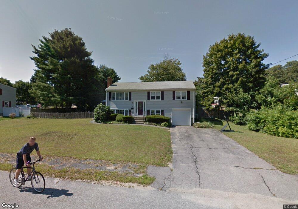
15 Sherman Rd Millis, MA 02054
Estimated Value: $551,603 - $695,000
3
Beds
2
Baths
1,008
Sq Ft
$603/Sq Ft
Est. Value
About This Home
This home is located at 15 Sherman Rd, Millis, MA 02054 and is currently estimated at $608,151, approximately $603 per square foot. 15 Sherman Rd is a home located in Norfolk County with nearby schools including Clyde F Brown, Millis Middle School, and Millis High School.
Ownership History
Date
Name
Owned For
Owner Type
Purchase Details
Closed on
Oct 14, 2020
Sold by
Malewicz Peter P and Ryan Kathleen A
Bought by
Malewicz Lt
Current Estimated Value
Purchase Details
Closed on
Jan 29, 1996
Sold by
Lempa Kevin F and Lempa Sara A
Bought by
Malewicz Peter P
Home Financials for this Owner
Home Financials are based on the most recent Mortgage that was taken out on this home.
Original Mortgage
$137,500
Interest Rate
7.13%
Mortgage Type
Purchase Money Mortgage
Create a Home Valuation Report for This Property
The Home Valuation Report is an in-depth analysis detailing your home's value as well as a comparison with similar homes in the area
Home Values in the Area
Average Home Value in this Area
Purchase History
We collect this data history from publicly available records. To have your information removed, we recommend requesting removal directly through your county’s website.
| Date | Buyer | Sale Price | Title Company |
|---|---|---|---|
| Malewicz Lt | -- | None Available | |
| Malewicz Peter P | $157,500 | -- |
Source: Public Records
Mortgage History
We collect this data history from publicly available records. To have your information removed, we recommend requesting removal directly through your county’s website.
| Date | Status | Borrower | Loan Amount |
|---|---|---|---|
| Previous Owner | Malewicz Peter P | $137,500 |
Source: Public Records
Tax History
| Year | Tax Paid | Tax Assessment Tax Assessment Total Assessment is a certain percentage of the fair market value that is determined by local assessors to be the total taxable value of land and additions on the property. | Land | Improvement |
|---|---|---|---|---|
| 2025 | $8,753 | $533,700 | $236,000 | $297,700 |
| 2024 | $7,939 | $483,500 | $217,800 | $265,700 |
| 2023 | $7,487 | $428,100 | $173,600 | $254,500 |
| 2022 | $7,463 | $395,300 | $186,300 | $209,000 |
| 2021 | $6,932 | $353,300 | $161,000 | $192,300 |
| 2020 | $6,652 | $330,300 | $150,500 | $179,800 |
| 2019 | $5,937 | $317,500 | $137,700 | $179,800 |
| 2018 | $5,721 | $317,500 | $137,700 | $179,800 |
| 2017 | $5,248 | $284,900 | $118,500 | $166,400 |
| 2016 | $4,969 | $284,900 | $118,500 | $166,400 |
| 2015 | $4,843 | $284,900 | $118,500 | $166,400 |
Source: Public Records
Map
Nearby Homes
- 64 Village St
- 488R Main St
- 1280 Main St
- 51 Spencer St Unit 1
- 234-236-0 Pleasant St
- 45 Auburn Rd
- 324 Union St Unit 1
- 10 April Way
- 154-156 Acorn St
- 77 Dover Rd
- 37 Rockville Meadows
- 33 Myrtle St
- 6 Rivendell Ln
- 329 Orchard St
- 194 Ridge St
- 204 Ridge St
- 3 Pine Ridge Dr Unit 1
- 193 Orchard St
- 16 Day St
- 104 Myrtle St
Your Personal Tour Guide
Ask me questions while you tour the home.