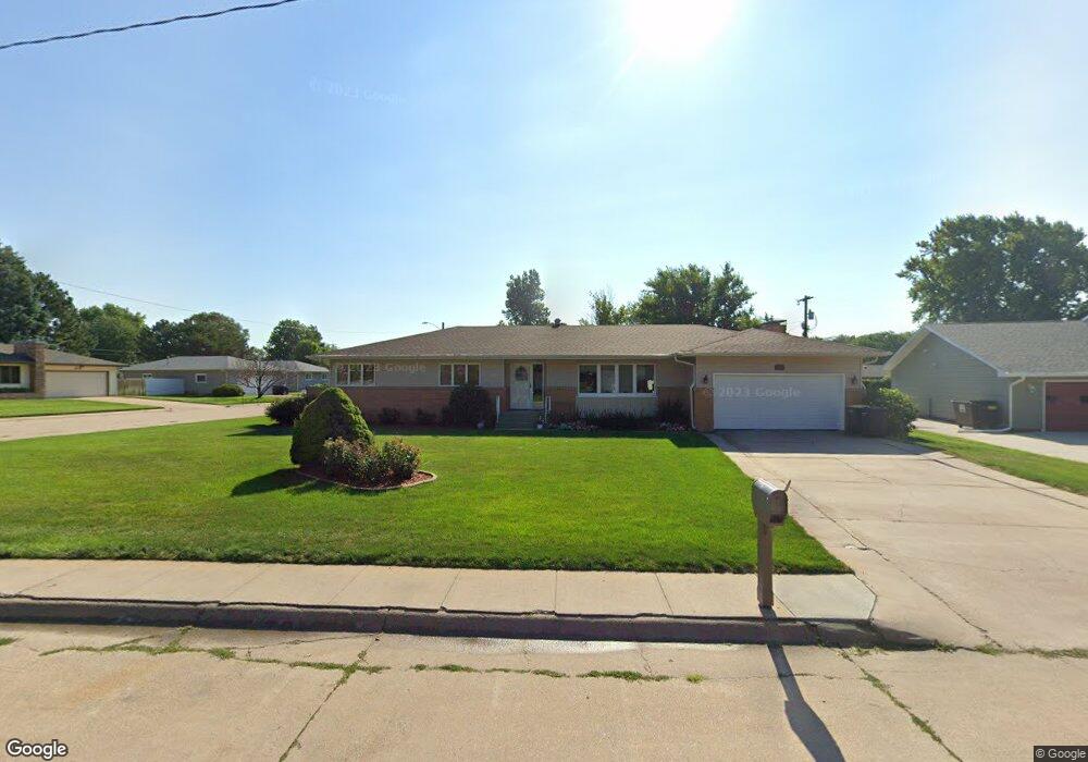
1500 Pershing Rd Hastings, NE 68901
Estimated Value: $360,494 - $382,000
3
Beds
3
Baths
1,905
Sq Ft
$195/Sq Ft
Est. Value
About This Home
This home is located at 1500 Pershing Rd, Hastings, NE 68901 and is currently estimated at $371,874, approximately $195 per square foot. 1500 Pershing Rd is a home located in Adams County with nearby schools including Hastings Senior High School, St. Michael's Preschool & Elementary School, and Zion Lutheran School.
Ownership History
Date
Name
Owned For
Owner Type
Purchase Details
Closed on
Aug 12, 2021
Sold by
Poppe Ricky D and Poppe Nancy K
Bought by
Niemeyer Mark William and Niemeyer Christine Anne
Current Estimated Value
Home Financials for this Owner
Home Financials are based on the most recent Mortgage that was taken out on this home.
Original Mortgage
$269,100
Outstanding Balance
$243,637
Interest Rate
2.9%
Mortgage Type
New Conventional
Estimated Equity
$128,237
Create a Home Valuation Report for This Property
The Home Valuation Report is an in-depth analysis detailing your home's value as well as a comparison with similar homes in the area
Home Values in the Area
Average Home Value in this Area
Purchase History
| Date | Buyer | Sale Price | Title Company |
|---|---|---|---|
| Niemeyer Mark William | $299,000 | Elizabeth Prairie Title |
Source: Public Records
Mortgage History
| Date | Status | Borrower | Loan Amount |
|---|---|---|---|
| Open | Niemeyer Mark William | $269,100 |
Source: Public Records
Tax History
| Year | Tax Paid | Tax Assessment Tax Assessment Total Assessment is a certain percentage of the fair market value that is determined by local assessors to be the total taxable value of land and additions on the property. | Land | Improvement |
|---|---|---|---|---|
| 2025 | $5,186 | $331,676 | $38,640 | $293,036 |
| 2024 | $5,217 | $324,349 | $38,640 | $285,709 |
| 2023 | $6,088 | $295,046 | $38,640 | $256,406 |
| 2022 | $5,337 | $236,933 | $38,640 | $198,293 |
| 2021 | $4,366 | $199,106 | $38,640 | $160,466 |
| 2020 | $4,129 | $191,465 | $38,640 | $152,825 |
| 2019 | $3,843 | $180,145 | $38,640 | $141,505 |
| 2018 | $3,639 | $169,705 | $28,200 | $141,505 |
| 2017 | $3,577 | $166,930 | $0 | $0 |
| 2016 | $3,386 | $157,855 | $28,200 | $129,655 |
| 2011 | -- | $146,420 | $25,380 | $121,040 |
Source: Public Records
Map
Nearby Homes
- 1401 Heritage Dr
- 1406 Sheridan Place
- 1318 Regency Dr
- 1233 Heritage Dr
- 1308 N Baltimore Ave
- 1506 Apache Ave
- 1834 Home St
- 1105 Jefferson Ave
- 1306 N Laird Ave
- 1109 N Webster Ave
- 910 Jefferson Ave
- 1010 N Webster Ave
- 1920 W 9th St
- 842 N Washington Ave
- 929 N Briggs Ave
- 1124 N Williams Ave
- 1131-1133 N Bellevue Ave
- 1701 Boyce St
- 1523 Boyce St
- 2019 W 9th St
- 1418 Pershing Rd
- 1425 Macarthur Rd
- 1415 Macarthur Rd
- 1706 Imperial Dr
- 1503 Pershing Rd
- 1410 Pershing Rd
- 1702 Imperial Dr
- 1716 Imperial Dr
- 1419 Pershing Rd
- 1409 Macarthur Rd
- 1509 Pershing Rd
- 1413 Pershing Rd
- 1622 Imperial Dr
- 1710 W 14th St
- 1401 Pershing Rd
- 1428 Macarthur Rd
- 1500 Heritage Dr
- 1405 Macarthur Rd
- 1436 Macarthur Rd
- 1412 Heritage Dr
Your Personal Tour Guide
Ask me questions while you tour the home.