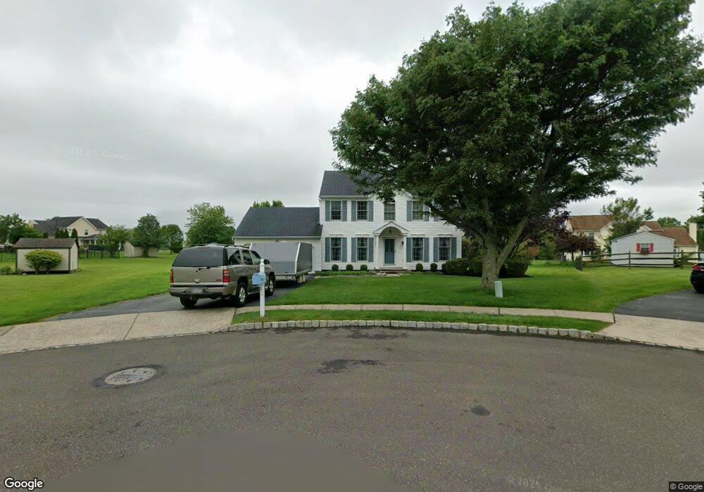
1505 Laurel Cir Warrington, PA 18976
Estimated Value: $652,000 - $809,000
4
Beds
3
Baths
2,118
Sq Ft
$346/Sq Ft
Est. Value
About This Home
This home is located at 1505 Laurel Cir, Warrington, PA 18976 and is currently estimated at $733,471, approximately $346 per square foot. 1505 Laurel Cir is a home located in Bucks County with nearby schools including Barclay Elementary School, Tamanend Middle School, and Central Bucks High School - South.
Ownership History
Date
Name
Owned For
Owner Type
Purchase Details
Closed on
Dec 28, 1995
Sold by
Quaker Group Associates Lp
Bought by
Sawyer Thomas R and Sawyer Maureen E
Current Estimated Value
Home Financials for this Owner
Home Financials are based on the most recent Mortgage that was taken out on this home.
Original Mortgage
$167,000
Outstanding Balance
$4,424
Interest Rate
7.1%
Estimated Equity
$729,047
Create a Home Valuation Report for This Property
The Home Valuation Report is an in-depth analysis detailing your home's value as well as a comparison with similar homes in the area
Home Values in the Area
Average Home Value in this Area
Purchase History
| Date | Buyer | Sale Price | Title Company |
|---|---|---|---|
| Sawyer Thomas R | $208,785 | Lawyers Title Insurance Co |
Source: Public Records
Mortgage History
| Date | Status | Borrower | Loan Amount |
|---|---|---|---|
| Open | Sawyer Thomas R | $167,000 |
Source: Public Records
Tax History
| Year | Tax Paid | Tax Assessment Tax Assessment Total Assessment is a certain percentage of the fair market value that is determined by local assessors to be the total taxable value of land and additions on the property. | Land | Improvement |
|---|---|---|---|---|
| 2025 | $6,935 | $39,840 | $11,000 | $28,840 |
| 2024 | $6,935 | $39,840 | $11,000 | $28,840 |
| 2023 | $6,715 | $39,840 | $11,000 | $28,840 |
| 2022 | $6,640 | $39,840 | $11,000 | $28,840 |
| 2021 | $6,566 | $39,840 | $11,000 | $28,840 |
| 2020 | $6,566 | $39,840 | $11,000 | $28,840 |
| 2019 | $6,526 | $39,840 | $11,000 | $28,840 |
| 2018 | $6,526 | $39,840 | $11,000 | $28,840 |
| 2017 | $6,476 | $39,840 | $11,000 | $28,840 |
| 2016 | $6,476 | $39,840 | $11,000 | $28,840 |
| 2015 | -- | $39,840 | $11,000 | $28,840 |
| 2014 | -- | $39,840 | $11,000 | $28,840 |
Source: Public Records
Map
Nearby Homes
- 1489 Stony Rd
- 1477 Stony Rd Unit RUTLEDGE
- 1477 Stony Rd
- 1501 Stony Rd
- 1494 Breton Hill Dr
- 0 Stony Rd Unit ROLLINS
- 0 Stony Rd Unit RAINTREE
- 0 Stony Rd Unit KINGSWOOD
- 0 Stony Rd Unit CLOVERFIELD
- 0 Stony Rd Unit MAYWEATHER
- 1651 Ramblewood Ln
- 1465 Breton Hill Dr
- 0 W Bristol Rd
- 1410 Windsor Dr
- 1646 Rockcress Dr
- 1638 Mayfield Cir
- 1705 Pittner Place
- 1621 Yorktown Rd Unit 50
- 1026 Surrey Ln
- 1503 Sweetbriar Dr
- 1506 Laurel Cir
- 1503 Laurel Cir
- 1481 Greenleaf Dr N
- 1485 Greenleaf Dr N
- 1473 Greenleaf Dr N
- 1479 Greenleaf Dr N
- 1504 Laurel Cir
- 1471 Greenleaf Dr N
- 1487 Greenleaf Dr N
- 1477 Greenleaf Dr N
- 1502 Laurel Cir
- 1475 Greenleaf Dr N
- 1501 Laurel Cir
- 1500 Laurel Cir
- 1469 Greenleaf Dr N
- 1442 Bentley Dr
- 1440 Bentley Dr
- 1480 Greenleaf Dr N
- 1493 Bentley Dr
- 1436 Bentley Dr
Your Personal Tour Guide
Ask me questions while you tour the home.