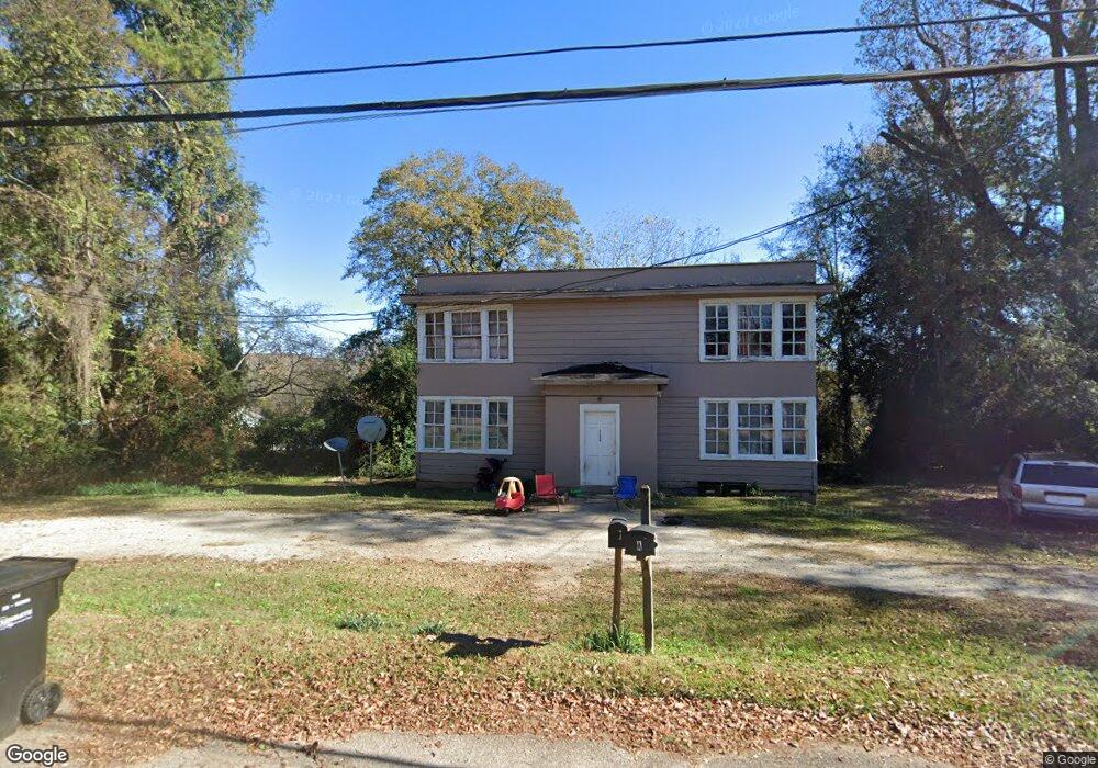
1506 5th Ave West Point, GA 31833
Estimated Value: $99,180 - $245,000
4
Beds
2
Baths
1,850
Sq Ft
$97/Sq Ft
Est. Value
About This Home
This home is located at 1506 5th Ave, West Point, GA 31833 and is currently estimated at $178,727, approximately $96 per square foot. 1506 5th Ave is a home located in Troup County with nearby schools including West Point Elementary School, Long Cane Elementary School, and Whitesville Road Elementary School.
Ownership History
Date
Name
Owned For
Owner Type
Purchase Details
Closed on
Jul 20, 1992
Sold by
Ennis David
Bought by
Calvin L Williams
Current Estimated Value
Purchase Details
Closed on
Nov 14, 1991
Sold by
Smith Mae W
Bought by
Ennis David
Purchase Details
Closed on
Jan 23, 1987
Sold by
Ennis Ennis and Ennis Evans
Bought by
Smith Mae W
Purchase Details
Closed on
Dec 1, 1985
Sold by
Martha Thomas and Martha Ayres
Bought by
Ennis Ennis and Ennis Evans
Purchase Details
Closed on
Oct 9, 1975
Sold by
Olivers
Bought by
Martha Thomas and Martha Ayres
Purchase Details
Closed on
Mar 22, 1956
Sold by
Gooding R C
Bought by
Olivers
Create a Home Valuation Report for This Property
The Home Valuation Report is an in-depth analysis detailing your home's value as well as a comparison with similar homes in the area
Home Values in the Area
Average Home Value in this Area
Purchase History
| Date | Buyer | Sale Price | Title Company |
|---|---|---|---|
| Calvin L Williams | $20,000 | -- | |
| Ennis David | -- | -- | |
| Smith Mae W | $29,000 | -- | |
| Ennis Ennis | $22,000 | -- | |
| Martha Thomas | $12,000 | -- | |
| Olivers | -- | -- |
Source: Public Records
Tax History
| Year | Tax Paid | Tax Assessment Tax Assessment Total Assessment is a certain percentage of the fair market value that is determined by local assessors to be the total taxable value of land and additions on the property. | Land | Improvement |
|---|---|---|---|---|
| 2025 | $424 | $12,160 | $1,312 | $10,848 |
| 2024 | $430 | $12,160 | $2,240 | $9,920 |
| 2023 | $329 | $12,080 | $2,240 | $9,840 |
| 2022 | $317 | $11,360 | $2,240 | $9,120 |
| 2021 | $249 | $9,720 | $1,200 | $8,520 |
| 2020 | $310 | $10,280 | $1,200 | $9,080 |
| 2019 | $223 | $7,400 | $1,200 | $6,200 |
| 2018 | $226 | $7,480 | $1,600 | $5,880 |
| 2017 | $226 | $7,480 | $1,600 | $5,880 |
| 2016 | $277 | $9,182 | $1,600 | $7,582 |
| 2015 | $265 | $8,787 | $1,205 | $7,582 |
| 2014 | $254 | $8,388 | $1,205 | $7,183 |
| 2013 | -- | $8,981 | $1,205 | $7,776 |
Source: Public Records
Map
Nearby Homes
- 1007 4th Ave
- 1508 N 4th Ave
- 403 N 15th St
- 712 4th Ave
- 1026 N 6th Ave
- 1903 Ridgewood Dr
- 1202 E 9th St
- 811 Cherry Dr
- 900 E 9th St
- 508 Pine St
- 707 E 7th St
- 514 N 8th Ave
- 506 E 6th St
- 302 N 6th Ave
- 0 Ga Highway 0116 Unit 10619139
- 1104 E 8th St
- 0 Arrowhead Dr Unit 10451860
- 1508 N 15th Dr
- 509 Cleveland St
- 0 Samples Rd Unit 10705121
Your Personal Tour Guide
Ask me questions while you tour the home.