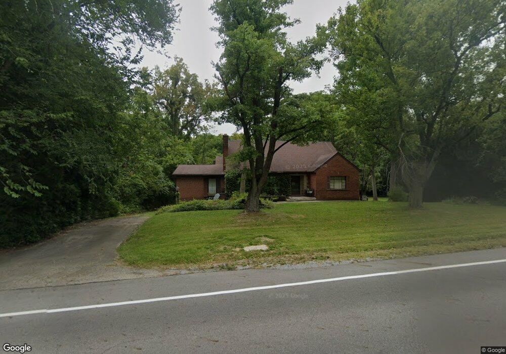
152 Moorefield Rd Springfield, OH 45502
Estimated Value: $143,403 - $294,000
Studio
--
Bath
--
Sq Ft
21,867
Sq Ft Lot
About This Home
This home is located at 152 Moorefield Rd, Springfield, OH 45502 and is currently estimated at $215,101. 152 Moorefield Rd is a home located in Clark County with nearby schools including Northridge Elementary School, Kenton Ridge Middle & High School, and Catholic Central Elementary School - Limestone Campus.
Ownership History
Date
Name
Owned For
Owner Type
Purchase Details
Closed on
Aug 1, 1995
Sold by
Estelle W Duff Est
Bought by
Macgillivray Randy Macgillivray D and Macgillivray Orne E
Current Estimated Value
Purchase Details
Closed on
Jun 23, 1995
Sold by
Shuey Samuel S
Bought by
Schneider Nancy A
Purchase Details
Closed on
Dec 15, 1994
Sold by
Bolen Wanda J
Bought by
Roby David D and Roby Patricia
Purchase Details
Closed on
Sep 2, 1994
Sold by
Yeazell Judith A
Bought by
Bolen Wanda J and Bolen Larry
Purchase Details
Closed on
Jun 2, 1986
Sold by
Gianakopoulos Aristides G
Bought by
Dotson James G and Dotson Kathleen L
Create a Home Valuation Report for This Property
The Home Valuation Report is an in-depth analysis detailing your home's value as well as a comparison with similar homes in the area
Home Values in the Area
Average Home Value in this Area
Purchase History
| Date | Buyer | Sale Price | Title Company |
|---|---|---|---|
| Macgillivray Randy Macgillivray D | $140,000 | -- | |
| Schneider Nancy A | $35,000 | -- | |
| Roby David D | $29,986 | -- | |
| Bolen Wanda J | $12,000 | -- | |
| Dotson James G | $15,000 | -- |
Source: Public Records
Tax History
| Year | Tax Paid | Tax Assessment Tax Assessment Total Assessment is a certain percentage of the fair market value that is determined by local assessors to be the total taxable value of land and additions on the property. | Land | Improvement |
|---|---|---|---|---|
| 2025 | $373 | $9,590 | $8,930 | $660 |
| 2024 | $361 | $8,340 | $6,540 | $1,800 |
| 2023 | $361 | $8,340 | $6,540 | $1,800 |
| 2022 | $367 | $8,340 | $6,540 | $1,800 |
| 2021 | $367 | $7,160 | $5,360 | $1,800 |
| 2020 | $367 | $7,160 | $5,360 | $1,800 |
| 2019 | $374 | $7,160 | $5,360 | $1,800 |
| 2018 | $368 | $6,750 | $4,950 | $1,800 |
| 2017 | $316 | $6,752 | $4,949 | $1,803 |
| 2016 | $314 | $6,752 | $4,949 | $1,803 |
| 2015 | $326 | $6,752 | $4,949 | $1,803 |
| 2014 | $326 | $6,752 | $4,949 | $1,803 |
| 2013 | $319 | $6,752 | $4,949 | $1,803 |
Source: Public Records
Map
Nearby Homes
- 0 Moorefield Rd
- 519 Moorefield Rd
- 5300 Brookshire Ln
- 4733 Curtis Dr
- 4741 Cullen Ave
- 1052 Cheyenne Ave Unit 1052
- 4802 Willowbrook Dr
- 1309 Richmoor Rd
- 5235 W Ridgewood Rd
- 937 Willow Rd
- 1341 Student Ave
- 1521 Erika Dr
- 4322 Midfield St Unit 15
- 4446 Ridgewood Rd E Unit 3
- 4256 Midfield St Unit 9
- 1415 Montego Dr
- 4577 Reno Ln Unit 2
- 1398 Elizabeth Ct Unit 66
- 4652 Reno Ln Unit 15
- 1201 Kingsgate Rd
- 152 Moorefield Rd
- 138 Moorefield Rd
- 145 Wenova Dr
- 125 Wenova Dr
- 130 Wenova Dr
- 92 Moorefield Rd
- 150 Wenova Dr
- 140 Wenova Dr
- 80 Moorefield Rd
- 5170 Urbana Rd
- 355 Moorefield Rd
- 200 Wenova Dr
- 361 Moorefield Rd
- 350 Moorefield Rd
- 2 Moorefield Rd
- 4560 Highlander Ln
- 4670 Highlander Ln
- 4670 Highlander Ln Unit 4
- 1 Moorefield Rd
- 4900 Highlander Ln
Your Personal Tour Guide
Ask me questions while you tour the home.