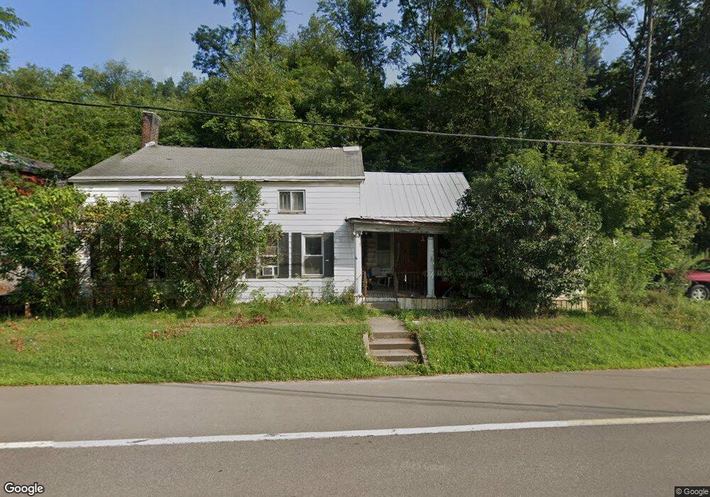
155 State Highway 12 Chenango Forks, NY 13746
Estimated Value: $120,000 - $180,000
2
Beds
1
Bath
1,785
Sq Ft
$85/Sq Ft
Est. Value
About This Home
This home is located at 155 State Highway 12, Chenango Forks, NY 13746 and is currently estimated at $151,967, approximately $85 per square foot. 155 State Highway 12 is a home located in Chenango County with nearby schools including Chenango Forks Elementary School, Chenango Forks Middle School, and Chenango Forks High School.
Ownership History
Date
Name
Owned For
Owner Type
Purchase Details
Closed on
Jun 5, 2008
Sold by
Marvin Daniel
Bought by
Marvin Daniel
Current Estimated Value
Purchase Details
Closed on
Nov 8, 1999
Sold by
Knapp Philip
Bought by
Marvin Daniel E
Purchase Details
Closed on
Jun 11, 1998
Sold by
Manasse Melvin
Bought by
Knapp Philip
Purchase Details
Closed on
Jan 31, 1998
Sold by
Schott Aka Randesi Dorothy A
Bought by
Manasse Melvin and Manasse Kathryn
Purchase Details
Closed on
Aug 19, 1994
Sold by
Pollio Alexander Pollio Margar
Bought by
Schott Dorothy A and Randesi Michael J
Create a Home Valuation Report for This Property
The Home Valuation Report is an in-depth analysis detailing your home's value as well as a comparison with similar homes in the area
Home Values in the Area
Average Home Value in this Area
Purchase History
We collect this data history from publicly available records. To have your information removed, we recommend requesting removal directly through your county’s website.
| Date | Buyer | Sale Price | Title Company |
|---|---|---|---|
| Marvin Daniel | -- | David Cohen | |
| Marvin Daniel E | $36,500 | Edward A Rantanen | |
| Knapp Philip | $20,000 | -- | |
| Manasse Melvin | $22,182 | -- | |
| Schott Dorothy A | $40,000 | -- |
Source: Public Records
Tax History
| Year | Tax Paid | Tax Assessment Tax Assessment Total Assessment is a certain percentage of the fair market value that is determined by local assessors to be the total taxable value of land and additions on the property. | Land | Improvement |
|---|---|---|---|---|
| 2025 | $3,020 | $79,400 | $22,000 | $57,400 |
| 2024 | $3,652 | $79,400 | $22,000 | $57,400 |
| 2023 | $3,641 | $79,400 | $22,000 | $57,400 |
| 2022 | $3,561 | $79,400 | $22,000 | $57,400 |
| 2021 | $3,599 | $79,400 | $22,000 | $57,400 |
| 2020 | $2,921 | $79,400 | $22,000 | $57,400 |
| 2019 | $2,517 | $79,400 | $22,000 | $57,400 |
| 2018 | $2,517 | $79,400 | $22,000 | $57,400 |
| 2017 | $2,477 | $79,400 | $22,000 | $57,400 |
| 2016 | $2,475 | $79,400 | $22,000 | $57,400 |
| 2015 | -- | $79,400 | $22,000 | $57,400 |
| 2014 | -- | $79,400 | $22,000 | $57,400 |
Source: Public Records
Map
Nearby Homes
- 106 Highland Ln
- 142 Marshman Rd
- 120 Steed Rd
- 9 Parsons Rd
- 389 State Highway 12
- 227 Knapp Hill Rd
- 19 Brookside Ln
- 336 Parsons Rd
- 0WP Furman Rd
- 446 Conklin Hill Rd
- 661 Oak Hill Rd
- 115 Iona Ln
- 152 Alexander Rd
- 531 Conklin Hill Rd
- 245 County Road 9
- 358 Kattelville Rd
- 675 Knapp Hill Rd
- 70 Pamela Dr
- 1961 New York 12
- 404 Ballyhack Rd
- 147 State Highway 12
- 159 State Highway 12
- 143 State Highway 12
- 141 State Highway 12
- 167 State Highway 12
- 137 State Highway 12
- 133 State Highway 12
- 6384 State Route 79
- 6380 State Route 79
- 6400 State Route 79
- 105 Oak Grove Dr
- 6372 State Route 79
- 125 State Highway 12
- 7155 New York 79
- 6385 New York 79
- 6385 State Route 79
- 6385 State Route 79
- 6407 State Route 79
- 6361 State Route 79
- 6410 State Route 79
Your Personal Tour Guide
Ask me questions while you tour the home.