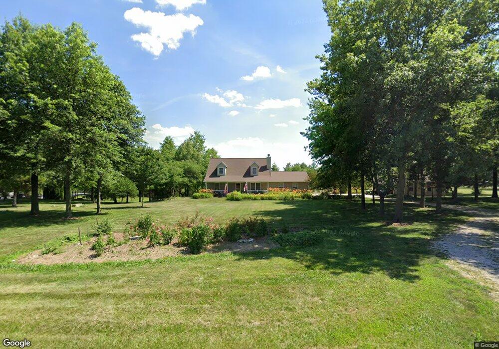
1562 Mule Rd Columbia, IL 62236
Estimated Value: $318,000 - $402,000
3
Beds
2
Baths
1,700
Sq Ft
$219/Sq Ft
Est. Value
About This Home
This home is located at 1562 Mule Rd, Columbia, IL 62236 and is currently estimated at $372,872, approximately $219 per square foot. 1562 Mule Rd is a home located in St. Clair County with nearby schools including Bluffview Elementary School and Dupo High School.
Ownership History
Date
Name
Owned For
Owner Type
Purchase Details
Closed on
May 9, 2025
Sold by
Bacon Arthur D and Bacon Susan E
Bought by
Bacon Arthur D and Arthur D Bacon & Susan E Bacon Family Tr
Current Estimated Value
Purchase Details
Closed on
Jul 18, 2008
Sold by
Lepere Randy L
Bought by
Bacon Arthur D and Bacon Susan E
Home Financials for this Owner
Home Financials are based on the most recent Mortgage that was taken out on this home.
Original Mortgage
$60,000
Interest Rate
6.15%
Mortgage Type
Purchase Money Mortgage
Create a Home Valuation Report for This Property
The Home Valuation Report is an in-depth analysis detailing your home's value as well as a comparison with similar homes in the area
Home Values in the Area
Average Home Value in this Area
Purchase History
| Date | Buyer | Sale Price | Title Company |
|---|---|---|---|
| Bacon Arthur D | -- | None Available | |
| Bacon Arthur D | $231,000 | Freedom Title |
Source: Public Records
Mortgage History
| Date | Status | Borrower | Loan Amount |
|---|---|---|---|
| Previous Owner | Bacon Arthur D | $60,000 |
Source: Public Records
Tax History
| Year | Tax Paid | Tax Assessment Tax Assessment Total Assessment is a certain percentage of the fair market value that is determined by local assessors to be the total taxable value of land and additions on the property. | Land | Improvement |
|---|---|---|---|---|
| 2024 | $5,611 | $107,222 | $12,387 | $94,835 |
| 2023 | $5,449 | $99,630 | $11,510 | $88,120 |
| 2022 | $5,200 | $93,452 | $10,796 | $82,656 |
| 2021 | $4,861 | $87,947 | $10,160 | $77,787 |
| 2020 | $0 | $74,439 | $9,302 | $65,137 |
| 2019 | $4,307 | $74,439 | $9,302 | $65,137 |
| 2018 | $4,116 | $71,023 | $8,875 | $62,148 |
| 2017 | $3,991 | $65,999 | $8,247 | $57,752 |
| 2016 | $4,044 | $64,532 | $7,973 | $56,559 |
| 2014 | $3,790 | $64,532 | $7,973 | $56,559 |
| 2013 | $4,840 | $66,031 | $8,158 | $57,873 |
Source: Public Records
Map
Nearby Homes
- 2213 Stone Gate Dr
- 2113 S Main St
- 1383 Walnut Ridge Dr
- 4 Ogle Estates
- 5 Ogle Estates
- 7 Ogle Estates
- 1374 Walnut Ridge Dr
- 500 Micahs Way
- 302 Fox Run Dr
- 1 Ogle Estates
- 3 Ogle Estates
- 0 Timber Rock Lot 10 Unit MIS25078396
- 0 Timber Rock Lot 18 Unit MIS25078275
- 0 Timber Rock Lot 13 Unit MIS25078387
- 0 Timber Rock Lot 15 Unit MIS25078279
- 0 Timber Rock Lot 8 Unit MIS25078403
- 0 Timber Rock Lot 5 Unit MAR24052087
- 0 Timber Rock Lot 5 Unit MIS25078406
- 0 Timber Rock Lot 7 Unit MIS25078404
- 0 Timber Rock Lot 11 Unit MIS25078395
Your Personal Tour Guide
Ask me questions while you tour the home.