
Seller's Agent in 2026
Ryan Casey
William Raveis Real Estate
(401) 316-8346
2 in this area
112 Total Sales
Estimated Value: $383,515 - $393,000
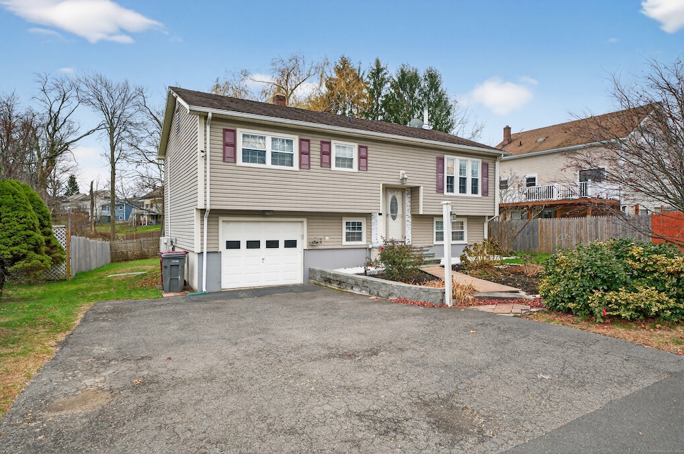
Move-in ready and beautifully cared for, this 4-bedroom Raised Ranch offers modern updates, great outdoor space, and the convenience of public utilities. The main level features a bright living area, an updated kitchen with contemporary finishes, and two comfortable bedrooms along with a refreshed full bath. The lower level includes two additional bedrooms and a second updated bathroom, creating a practical and well-designed layout. Outside, enjoy a large yard highlighted by a gorgeous old-growth tree and a nice back deck perfect for relaxing or entertaining. Additional features include an attached one-car garage, vinyl siding, and efficient ductless air conditioning for year-round comfort. With public water and public sewer plus a convenient location close to shopping, dining, parks, and commuter routes, this well-cared-for home is truly move-in ready with nothing left to do but enjoy.
Last Agent to Sell the Property
William Raveis Real Estate Brokerage Phone: (401) 316-8346 License #RES.0806074 Listed on: 11/26/2025
| Date | Buyer | Sale Price | Title Company |
|---|---|---|---|
| Taylor Yolanda | $391,500 | -- | |
| Mustafa Erol | $225,000 | -- | |
| Schwartz Robert | $119,500 | -- |
| Date | Status | Borrower | Loan Amount |
|---|---|---|---|
| Open | Taylor Yolanda | $18,750 | |
| Previous Owner | Schwartz Robert | $217,388 | |
| Previous Owner | Schwartz Robert | $218,589 | |
| Previous Owner | Schwartz Robert | $226,675 |
| Date | Event | Price | List to Sale | Price per Sq Ft |
|---|---|---|---|---|
| 01/16/2026 01/16/26 | Sold | $391,500 | +0.4% | $230 / Sq Ft |
| 12/17/2025 12/17/25 | Pending | -- | -- | -- |
| 11/28/2025 11/28/25 | For Sale | $389,900 | -- | $229 / Sq Ft |
| Year | Tax Paid | Tax Assessment Tax Assessment Total Assessment is a certain percentage of the fair market value that is determined by local assessors to be the total taxable value of land and additions on the property. | Land | Improvement |
|---|---|---|---|---|
| 2025 | $6,779 | $170,380 | $30,450 | $139,930 |
| 2024 | $7,120 | $170,380 | $30,450 | $139,930 |
| 2023 | $7,625 | $170,380 | $30,450 | $139,930 |
| 2022 | $5,927 | $124,120 | $32,130 | $91,990 |
| 2021 | $5,927 | $124,120 | $32,130 | $91,990 |
| 2020 | $5,927 | $124,120 | $32,130 | $91,990 |
| 2019 | $5,865 | $124,120 | $32,130 | $91,990 |
| 2018 | $5,501 | $113,770 | $41,090 | $72,680 |
| 2017 | $5,524 | $113,770 | $41,090 | $72,680 |
| 2016 | $5,361 | $112,460 | $41,090 | $71,370 |
| 2015 | $5,125 | $112,460 | $41,090 | $71,370 |
| 2014 | $5,067 | $112,460 | $41,090 | $71,370 |
| 2012 | $5,166 | $153,970 | $49,030 | $104,940 |
Seller's Agent in 2026
Ryan Casey
William Raveis Real Estate
(401) 316-8346
2 in this area
112 Total Sales
Buyer's Agent in 2026
Margo Lopez
US Asset Realty
(203) 464-5411
5 in this area
33 Total Sales
Source: SmartMLS
MLS Number: 24142291
APN: NAUG-000092E-E094222-000001
Disclaimer: Certain information contained herein is derived from information provided by parties other than Homes.com. All information provided is deemed reliable, but is not guaranteed to be accurate and should be independently verified.
![]() IDX information is provided exclusively for personal, non-commercial use, and may not be used for any purpose other than to identify prospective properties consumers may be interested in purchasing. Information is deemed reliable but not guaranteed.
IDX information is provided exclusively for personal, non-commercial use, and may not be used for any purpose other than to identify prospective properties consumers may be interested in purchasing. Information is deemed reliable but not guaranteed.
Ask me questions while you tour the home.