K
Seller's Agent in 2026
Kate Stevens
Wilson Realty
18 in this area
20 Total Sales
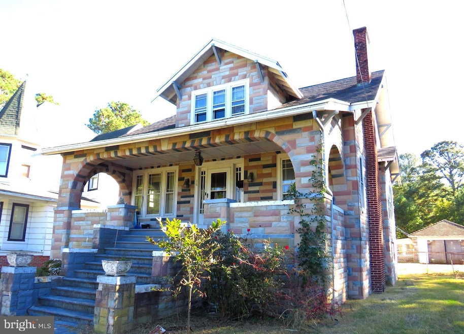


Attention all investors and renovators!! This home has so much to offer with its unique architectural details. Just within city limits of Crisfield. This property also comes with two additional parcels of land, expanding the total size to .59 acres! Fenced side yard, with additional outbuildings. Garage is attached to potential guest house. Full basement that provides optimal storage space. Additional side entrances at basement. This home comes with a beautiful front porch with arched detail as soon as you walk in. Hard wood flooring all throughout the home, with original light fixtures and doors throughout. 3 generous bedrooms with 1 1/2 bathrooms. Schedule your tour today and envision all the potential this home has to offer!
Last Agent to Sell the Property
(410) 968-1882 wilsonrealty@verizon.net Wilson Realty Brokerage Phone: 4109681882 Listed on: 10/24/2025
Last Buyer's Agent
(410) 749-1818 shawnlong@shawnsellsdelmarva.com ERA Martin Associates License #5020034
| Date | Type | Sale Price | Title Company |
|---|---|---|---|
| Deed | $130,000 | First American Title | |
| Deed | $64,938 | None Listed On Document |
| Date | Status | Loan Amount | Loan Type |
|---|---|---|---|
| Previous Owner | $68,819 | New Conventional |
| Date | Event | Price | List to Sale | Price per Sq Ft |
|---|---|---|---|---|
| 02/13/2026 02/13/26 | Sold | $130,000 | -21.2% | $83 / Sq Ft |
| 10/24/2025 10/24/25 | For Sale | $165,000 | -- | $105 / Sq Ft |
| Year | Tax Paid | Tax Assessment Tax Assessment Total Assessment is a certain percentage of the fair market value that is determined by local assessors to be the total taxable value of land and additions on the property. | Land | Improvement |
|---|---|---|---|---|
| 2025 | $3,238 | $145,600 | $26,200 | $119,400 |
| 2024 | $1,306 | $131,533 | $0 | $0 |
| 2023 | $1,306 | $117,467 | $0 | $0 |
| 2022 | $1,150 | $103,400 | $18,000 | $85,400 |
| 2021 | $1,150 | $103,233 | $0 | $0 |
| 2020 | $1,146 | $103,067 | $0 | $0 |
| 2019 | $1,144 | $102,900 | $18,000 | $84,900 |
| 2018 | $1,144 | $102,900 | $18,000 | $84,900 |
| 2017 | $1,144 | $102,900 | $0 | $0 |
| 2016 | $2,137 | $107,800 | $0 | $0 |
| 2015 | $2,137 | $107,800 | $0 | $0 |
| 2014 | $1,308 | $107,800 | $0 | $0 |
K
Seller's Agent in 2026
Kate Stevens
Wilson Realty
18 in this area
20 Total Sales

Buyer's Agent in 2026
Shawn M Long
ERA Martin Associates
(410) 749-1818
1 in this area
6 Total Sales
Source: Bright MLS
MLS Number: MDSO2006550
APN: 07-117671
Disclaimer: Certain information contained herein is derived from information provided by parties other than Homes.com. All information provided is deemed reliable, but is not guaranteed to be accurate and should be independently verified.
![]() The data relating to real estate for sale on this website appears in part through the BRIGHT Internet Data Exchange program, a voluntary cooperative exchange of property listing data between licensed real estate brokerage firms, and is provided by BRIGHT through a licensing agreement.
The data relating to real estate for sale on this website appears in part through the BRIGHT Internet Data Exchange program, a voluntary cooperative exchange of property listing data between licensed real estate brokerage firms, and is provided by BRIGHT through a licensing agreement.
Listing information is from various brokers who participate in the Bright MLS IDX program and not all listings may be visible on the site.
The property information being provided on or through the website is for the personal, non-commercial use of consumers and such information may not be used for any purpose other than to identify prospective properties consumers may be interested in purchasing.
Some properties which appear for sale on the website may no longer be available because they are for instance, under contract, sold or are no longer being offered for sale.
Property information displayed is deemed reliable but is not guaranteed.
Copyright 2026 Bright MLS, Inc.
Ask me questions while you tour the home.