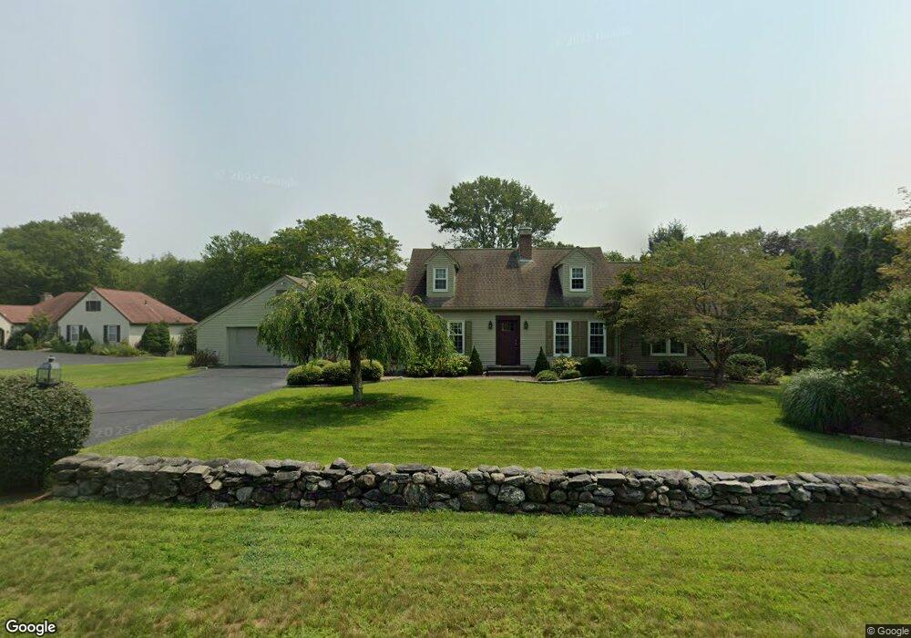
161 Case St Norwich, CT 06360
Yantic NeighborhoodEstimated Value: $415,000 - $552,000
3
Beds
3
Baths
2,204
Sq Ft
$211/Sq Ft
Est. Value
About This Home
This home is located at 161 Case St, Norwich, CT 06360 and is currently estimated at $464,509, approximately $210 per square foot. 161 Case St is a home located in New London County with nearby schools including Moriarty Magnet Elementary School, Kelly STEAM Magnet Middle School, and Stoneview Children's University.
Ownership History
Date
Name
Owned For
Owner Type
Purchase Details
Closed on
Jan 29, 1997
Sold by
Balsley Donald C and Forrest Susan J
Bought by
Mikkelson Mark E and Krista Mikkelson M
Current Estimated Value
Purchase Details
Closed on
Jul 22, 1988
Sold by
Troeger James
Bought by
Balsley Donald
Create a Home Valuation Report for This Property
The Home Valuation Report is an in-depth analysis detailing your home's value as well as a comparison with similar homes in the area
Home Values in the Area
Average Home Value in this Area
Purchase History
| Date | Buyer | Sale Price | Title Company |
|---|---|---|---|
| Mikkelson Mark E | $219,000 | -- | |
| Mikkelson Mark E | $219,000 | -- | |
| Balsley Donald | $270,000 | -- |
Source: Public Records
Mortgage History
| Date | Status | Borrower | Loan Amount |
|---|---|---|---|
| Open | Balsley Donald | $200,000 | |
| Closed | Balsley Donald | $50,000 | |
| Closed | Balsley Donald | $198,000 |
Source: Public Records
Tax History
| Year | Tax Paid | Tax Assessment Tax Assessment Total Assessment is a certain percentage of the fair market value that is determined by local assessors to be the total taxable value of land and additions on the property. | Land | Improvement |
|---|---|---|---|---|
| 2025 | $8,149 | $234,100 | $53,200 | $180,900 |
| 2024 | $7,784 | $234,100 | $53,200 | $180,900 |
| 2023 | $6,637 | $158,600 | $45,700 | $112,900 |
| 2022 | $6,690 | $158,600 | $45,700 | $112,900 |
| 2021 | $6,717 | $158,600 | $45,700 | $112,900 |
| 2020 | $6,721 | $158,600 | $45,700 | $112,900 |
| 2019 | $6,446 | $158,600 | $45,700 | $112,900 |
| 2018 | $7,181 | $173,200 | $52,300 | $120,900 |
| 2017 | $7,044 | $173,200 | $52,300 | $120,900 |
| 2016 | $7,221 | $173,200 | $52,300 | $120,900 |
| 2015 | $7,169 | $173,200 | $52,300 | $120,900 |
| 2014 | $6,762 | $173,200 | $52,300 | $120,900 |
Source: Public Records
Map
Nearby Homes
- 1 Tanglewood Dr
- 18 Reservoir Rd
- 47 Huntington Ave
- 230 Vergason Ave
- 18 Caulkins Rd
- 89 Canterbury Turnpike
- 36 Scotland Rd
- 00 Plain Hill Rd
- 49 Forestview Dr
- 59 Forestview Dr
- 27 Parkwoods Dr Unit 27
- 61 Flyers Dr
- 60-70 Connecticut Ave
- 108 W Town St
- 42 Ox Hill Rd
- 380 Scotland Rd
- 341 Harland Rd
- 119 Harland Rd
- 26 Greene Ave Unit 7
- 0 Myrtle Dr
Your Personal Tour Guide
Ask me questions while you tour the home.