Estimated Value: $152,533 - $162,000
2
Beds
1
Bath
1,168
Sq Ft
$134/Sq Ft
Est. Value
About This Home
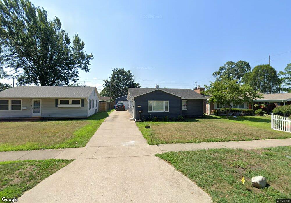
This home is located at 1612 Sheffield Ave, Niles, MI 49120 and is currently estimated at $156,633, approximately $134 per square foot. 1612 Sheffield Ave is a home located in Berrien County with nearby schools including Ballard Elementary School, Ring Lardner Middle School, and Oak Manor Sixth Grade Center.
Ownership History
Date
Name
Owned For
Owner Type
Purchase Details
Closed on
Oct 18, 2016
Sold by
Miller Heather and Mcgraw Heather M
Bought by
Mcgraw Heather M
Current Estimated Value
Home Financials for this Owner
Home Financials are based on the most recent Mortgage that was taken out on this home.
Original Mortgage
$71,600
Outstanding Balance
$33,533
Interest Rate
3.44%
Mortgage Type
New Conventional
Estimated Equity
$123,100
Purchase Details
Closed on
Sep 15, 2006
Sold by
Davis James E and Davis Roger A
Bought by
Miller Heather
Home Financials for this Owner
Home Financials are based on the most recent Mortgage that was taken out on this home.
Original Mortgage
$79,900
Interest Rate
6.7%
Mortgage Type
Unknown
Purchase Details
Closed on
Sep 20, 1988
Purchase Details
Closed on
Jan 16, 1984
Purchase Details
Closed on
Aug 30, 1983
Purchase Details
Closed on
Dec 30, 1977
Create a Home Valuation Report for This Property
The Home Valuation Report is an in-depth analysis detailing your home's value as well as a comparison with similar homes in the area
Home Values in the Area
Average Home Value in this Area
Purchase History
| Date | Buyer | Sale Price | Title Company |
|---|---|---|---|
| Mcgraw Heather M | -- | Attorney | |
| Miller Heather | $79,900 | Meridian Title Corporation | |
| -- | $21,900 | -- | |
| -- | $21,900 | -- | |
| -- | $21,900 | -- | |
| -- | $17,400 | -- |
Source: Public Records
Mortgage History
| Date | Status | Borrower | Loan Amount |
|---|---|---|---|
| Open | Mcgraw Heather M | $71,600 | |
| Closed | Miller Heather | $79,900 |
Source: Public Records
Tax History
| Year | Tax Paid | Tax Assessment Tax Assessment Total Assessment is a certain percentage of the fair market value that is determined by local assessors to be the total taxable value of land and additions on the property. | Land | Improvement |
|---|---|---|---|---|
| 2025 | $1,467 | $60,300 | $0 | $0 |
| 2024 | $1,152 | $59,200 | $0 | $0 |
| 2023 | $1,104 | $53,500 | $0 | $0 |
| 2022 | $1,052 | $38,900 | $0 | $0 |
| 2021 | $1,290 | $34,900 | $2,300 | $32,600 |
| 2020 | $1,276 | $34,800 | $0 | $0 |
| 2019 | $1,261 | $32,100 | $1,600 | $30,500 |
Source: Public Records
Map
Nearby Homes
- 1441 Clarendon Ave
- 1015 Lake St
- 607 N 18th St
- 1653 Regent St
- 1434 Sycamore St
- 1630 Forest Trail
- 1022 Howard St
- 115 Stowe Ct
- 1314 Ferry St
- 1301 Regent St
- 1123 N 9th St
- 31863 Heritage Place
- 1020 N 8th St
- 1919 Industrial Dr
- 1329 Oak St Unit C-2
- 810 Ferry St
- 816 Burns St
- 1621 Maple St
- 1648 Oak St
- 2802 Primrose Ct
- 1616 Sheffield Ave
- 1608 Sheffield Ave
- 1620 Sheffield Ave
- 1019 N 16th St
- 1609 Merrifield Ave
- 1615 Merrifield Ave
- 1624 Sheffield Ave
- 1619 Merrifield Ave
- 1101 N 16th St
- 1609 Sheffield Ave
- 1623 Merrifield Ave
- 1630 Sheffield Ave
- 1605 Sheffield Ave
- 1615 Sheffield Ave
- 1001 N 16th St
- 1621 Sheffield Ave
- 1020 N 16th St
- 1627 Merrifield Ave
- 1020 N 17th St
- 1625 Sheffield Ave
Your Personal Tour Guide
Ask me questions while you tour the home.