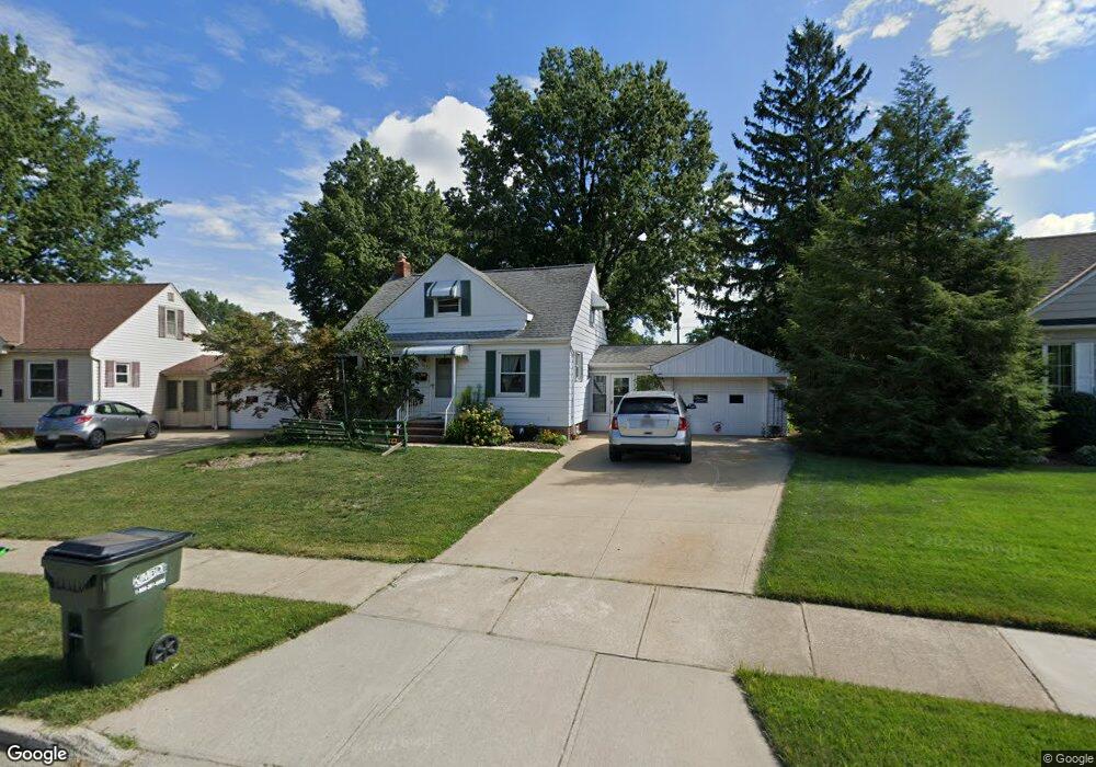
1613 Dennis Dr Wickliffe, OH 44092
Estimated Value: $193,567 - $212,000
3
Beds
2
Baths
1,123
Sq Ft
$180/Sq Ft
Est. Value
About This Home
This home is located at 1613 Dennis Dr, Wickliffe, OH 44092 and is currently estimated at $202,142, approximately $180 per square foot. 1613 Dennis Dr is a home located in Lake County with nearby schools including Wickliffe Elementary School, Wickliffe Middle School, and Wickliffe High School.
Ownership History
Date
Name
Owned For
Owner Type
Purchase Details
Closed on
Oct 22, 2008
Sold by
Bakos Anthony J and Bakos Melinda A
Bought by
Sheliga Amanda E
Current Estimated Value
Home Financials for this Owner
Home Financials are based on the most recent Mortgage that was taken out on this home.
Original Mortgage
$124,053
Outstanding Balance
$79,501
Interest Rate
5.94%
Mortgage Type
FHA
Estimated Equity
$122,641
Purchase Details
Closed on
Aug 5, 1997
Sold by
Demeester Gordon D and Kamm Christine V
Bought by
Bakos Anthony J and Imrie Melinda A
Home Financials for this Owner
Home Financials are based on the most recent Mortgage that was taken out on this home.
Original Mortgage
$82,950
Interest Rate
7.68%
Purchase Details
Closed on
Jan 1, 1990
Bought by
Demeester Gordon D
Create a Home Valuation Report for This Property
The Home Valuation Report is an in-depth analysis detailing your home's value as well as a comparison with similar homes in the area
Home Values in the Area
Average Home Value in this Area
Purchase History
We collect this data history from publicly available records. To have your information removed, we recommend requesting removal directly through your county’s website.
| Date | Buyer | Sale Price | Title Company |
|---|---|---|---|
| Sheliga Amanda E | $126,000 | Attorney | |
| Bakos Anthony J | $118,500 | Midland Title Security Inc | |
| Demeester Gordon D | -- | -- |
Source: Public Records
Mortgage History
We collect this data history from publicly available records. To have your information removed, we recommend requesting removal directly through your county’s website.
| Date | Status | Borrower | Loan Amount |
|---|---|---|---|
| Open | Sheliga Amanda E | $124,053 | |
| Previous Owner | Bakos Anthony J | $82,950 |
Source: Public Records
Tax History
| Year | Tax Paid | Tax Assessment Tax Assessment Total Assessment is a certain percentage of the fair market value that is determined by local assessors to be the total taxable value of land and additions on the property. | Land | Improvement |
|---|---|---|---|---|
| 2025 | $2,095 | $63,820 | $20,100 | $43,720 |
| 2024 | -- | $63,820 | $20,100 | $43,720 |
| 2023 | -- | $47,020 | $17,400 | $29,620 |
| 2022 | $4,146 | $47,020 | $17,400 | $29,620 |
| 2021 | $4,033 | $47,020 | $17,400 | $29,620 |
| 2020 | $3,758 | $37,620 | $13,920 | $23,700 |
| 2019 | $3,685 | $37,620 | $13,920 | $23,700 |
| 2018 | $3,286 | $39,390 | $14,750 | $24,640 |
| 2017 | $3,268 | $39,390 | $14,750 | $24,640 |
| 2016 | $3,282 | $39,390 | $14,750 | $24,640 |
| 2015 | $2,778 | $39,390 | $14,750 | $24,640 |
| 2014 | $2,455 | $39,390 | $14,750 | $24,640 |
| 2013 | $2,454 | $39,390 | $14,750 | $24,640 |
Source: Public Records
Map
Nearby Homes
- 1661 Empire Rd
- 1554 Rush Rd
- 1588 Mapledale Rd
- 1677 Mapledale Rd
- 1664 Douglas Rd
- 1663 Drenik Dr
- 1704 Drenik Dr
- 34345 Giovanni Ave
- 1529 Lee Terrace Dr Unit D8
- 5112 Shepherds Glen
- 5110 Shepherds Glen
- 30056 Euclid Ave Unit 14
- 1602 Lee Terrace Dr Unit C2
- 5104 Liberty Ln Unit A
- 1854 Drenik Dr
- 5094 Shepherds Glen
- 5092 Shepherds Glen
- 5090 Shepherds Glen
- 5095 Shepherds Glen
- 5091 Shepherds Glen
- 1609 Dennis Dr
- 1617 Dennis Dr
- 1605 Dennis Dr
- 1620 Empire Rd
- 1623 Dennis Dr
- 1624 Empire Rd
- 1614 Empire Rd
- 1628 Empire Rd
- 1608 Empire Rd
- 30528 Severn Ln
- 30526 Euclid Ave
- 1610 Dennis Dr
- 1629 Dennis Dr
- 1634 Empire Rd
- 30526 Severn Ln
- 1601 Dennis Dr
- 30524 Severn Ln
- 1618 Dennis Dr
- 1638 Empire Rd
- 1635 Dennis Dr
Your Personal Tour Guide
Ask me questions while you tour the home.