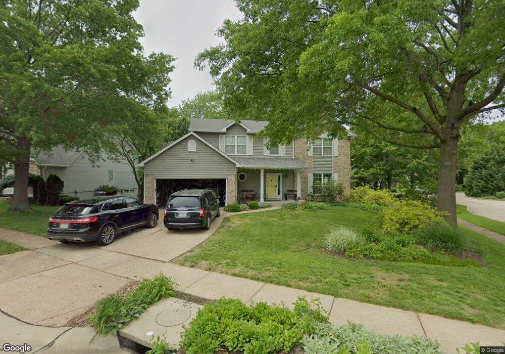
16170 Surfview Ct Grover, MO 63040
Estimated Value: $488,000 - $522,000
About This Home
This home is located at 16170 Surfview Ct, Grover, MO 63040 and is currently estimated at $500,897, approximately $204 per square foot. 16170 Surfview Ct is a home located in St. Louis County with nearby schools including Fairway Elementary School, Wildwood Middle School, and Eureka Senior High School.
Ownership History
We collect this data history from publicly available records. To have your information removed, we recommend requesting removal directly through your county’s website.
Purchase Details
Home Financials for this Owner
Home Financials are based on the most recent Mortgage that was taken out on this home.Purchase Details
Home Financials for this Owner
Home Financials are based on the most recent Mortgage that was taken out on this home.Home Values in the Area
Average Home Value in this Area
Purchase History
We collect this data history from publicly available records. To have your information removed, we recommend requesting removal directly through your county’s website.
| Date | Buyer | Sale Price | Title Company |
|---|---|---|---|
| $283,000 | None Available | ||
| $248,950 | -- |
Mortgage History
We collect this data history from publicly available records. To have your information removed, we recommend requesting removal directly through your county’s website.
| Date | Status | Borrower | Loan Amount |
|---|---|---|---|
| Closed | $203,000 | ||
| Closed | $199,150 |
Tax History
We collect this data history from publicly available records. To have your information removed, we recommend requesting removal directly through your county’s website.
| Year | Tax Paid | Tax Assessment Tax Assessment Total Assessment is a certain percentage of the fair market value that is determined by local assessors to be the total taxable value of land and additions on the property. | Land | Improvement |
|---|---|---|---|---|
| 2025 | $5,203 | $84,800 | $29,930 | $54,870 |
| 2024 | $5,203 | $74,830 | $18,700 | $56,130 |
| 2023 | $5,199 | $74,830 | $18,700 | $56,130 |
| 2022 | $4,728 | $63,200 | $18,700 | $44,500 |
| 2021 | $4,693 | $63,200 | $18,700 | $44,500 |
| 2020 | $4,642 | $59,600 | $16,830 | $42,770 |
| 2019 | $4,660 | $59,600 | $16,830 | $42,770 |
| 2018 | $4,109 | $49,550 | $11,230 | $38,320 |
| 2017 | $4,011 | $49,550 | $11,230 | $38,320 |
| 2016 | $4,281 | $50,860 | $11,230 | $39,630 |
| 2015 | $4,193 | $50,860 | $11,230 | $39,630 |
| 2014 | $4,164 | $49,250 | $11,720 | $37,530 |
Map
- 16201 Surfview Ct
- 401 Lea Harbor Ct
- 16475 Cove Landing Ct
- 311 Cove Landing Dr
- 340 Copper Lakes Blvd
- 107 Watercrest Ct
- 212 Harbour Pointe Dr
- 164 Crestmont Cir
- 6 Venice Place Ct
- 16227 Castlerea Blvd
- 16129 Sea Breeze Ct
- 471 Saint Thomas Isle Ln
- 11 Windjammer Ct
- 16129 Castlerea Blvd
- 514 Nantucket Springs Dr
- 405 Rapunzel Ln
- 119 Elderberry Ln
- 16141 Aurora Ct
- 16148 Aurora Ct
- 16609 Kolbie Manors Ct
- 505 Lighthouse Point Dr
- 16188 Surfview Ct
- 511 Lighthouse Point Dr
- 16181 Surfview Ct
- 16194 Surfview Ct
- 16187 Surfview Ct
- 506 Lighthouse Point Dr
- 462 Lighthouse Point Dr
- 16191 Surfview Ct
- 512 Lighthouse Point Dr
- 518 Lighthouse Point Dr
- 16166 Surfview Ct
- 455 Lighthouse Point Dr
- 502 Beacon Point Ln
- 16195 Surfview Ct
- 458 Lighthouse Point Dr
- 506 Beacon Point Ln
- 16161 Surfview Ct
- 442 Beacon Point Ln
- 327 Harbour Pointe Dr
Ask me questions while you tour the home.