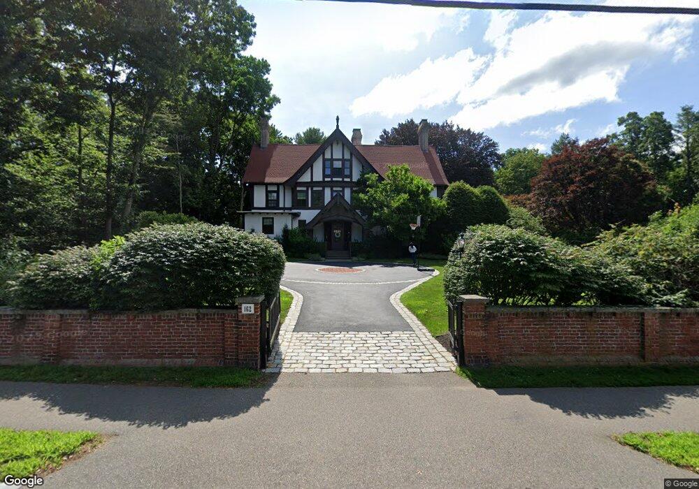
162 Central Ave Milton, MA 02186
Columbine Cliffs NeighborhoodEstimated Value: $1,925,000 - $2,719,000
About This Home
This home is located at 162 Central Ave, Milton, MA 02186 and is currently estimated at $2,248,139, approximately $415 per square foot. 162 Central Ave is a home located in Norfolk County with nearby schools including Milton High School, Conservatory Lab Upper School, and Saint John Paul II Catholic Academy.
Ownership History
We collect this data history from publicly available records. To have your information removed, we recommend requesting removal directly through your county’s website.
Purchase Details
Purchase Details
Home Financials for this Owner
Home Financials are based on the most recent Mortgage that was taken out on this home.Home Values in the Area
Average Home Value in this Area
Purchase History
We collect this data history from publicly available records. To have your information removed, we recommend requesting removal directly through your county’s website.
| Date | Buyer | Sale Price | Title Company |
|---|---|---|---|
| -- | None Available | ||
| $752,000 | -- |
Mortgage History
We collect this data history from publicly available records. To have your information removed, we recommend requesting removal directly through your county’s website.
| Date | Status | Borrower | Loan Amount |
|---|---|---|---|
| Previous Owner | $523,750 |
Tax History
We collect this data history from publicly available records. To have your information removed, we recommend requesting removal directly through your county’s website.
| Year | Tax Paid | Tax Assessment Tax Assessment Total Assessment is a certain percentage of the fair market value that is determined by local assessors to be the total taxable value of land and additions on the property. | Land | Improvement |
|---|---|---|---|---|
| 2025 | $16,943 | $1,527,800 | $498,100 | $1,029,700 |
| 2024 | $16,424 | $1,504,000 | $474,300 | $1,029,700 |
| 2023 | $15,653 | $1,373,100 | $451,800 | $921,300 |
| 2022 | $14,569 | $1,168,300 | $451,800 | $716,500 |
| 2021 | $14,507 | $1,104,900 | $422,500 | $682,400 |
| 2020 | $14,218 | $1,083,700 | $414,500 | $669,200 |
| 2019 | $13,867 | $1,052,100 | $402,400 | $649,700 |
| 2018 | $13,470 | $975,400 | $385,300 | $590,100 |
| 2017 | $12,611 | $930,000 | $367,000 | $563,000 |
| 2016 | $12,149 | $899,900 | $348,600 | $551,300 |
| 2015 | $11,630 | $834,300 | $295,400 | $538,900 |
Map
- 106 Central Ave
- 67 Maple St
- 24 School St
- 34 Avalon Rd
- 147 Canton Ave
- 13 Cantwell Rd
- 196 Canton Ave
- 40 Allen Cir
- 213 School St
- 54 River St Unit 2
- 60 Marilyn Rd
- 23-27 Cedar St Unit 25
- 23-27 Cedar St Unit 27
- 1241-1255 Adams St Unit F507
- 1243 Adams St Unit PM309
- 1243 Adams St Unit PM207
- 1245 Adams St Unit B210
- 21 Tanglewood Rd Unit 3
- 21 Tanglewood Rd Unit 2
- 76 Clearwater Dr
- 162 Central Ave
- 162 Central Ave Unit 1
- 1 Ruggles Ln
- 162 Central (W 2subdividable Lots)
- 148 Central Ave
- 170 Central Ave
- 114 Valley Rd
- 99 Valley Rd
- 173 Central Ave
- 45 Ruggles Ln
- 143 Central Ave
- 106 Valley Rd
- 57 Ruggles Ln
- 183 Central Ave
- 8 Ruggles Ln
- 3 Herrick Dr
- 1 Herrick Dr
- 5 Herrick Dr
- 120 Central Ave
- 190 Central Ave
Ask me questions while you tour the home.