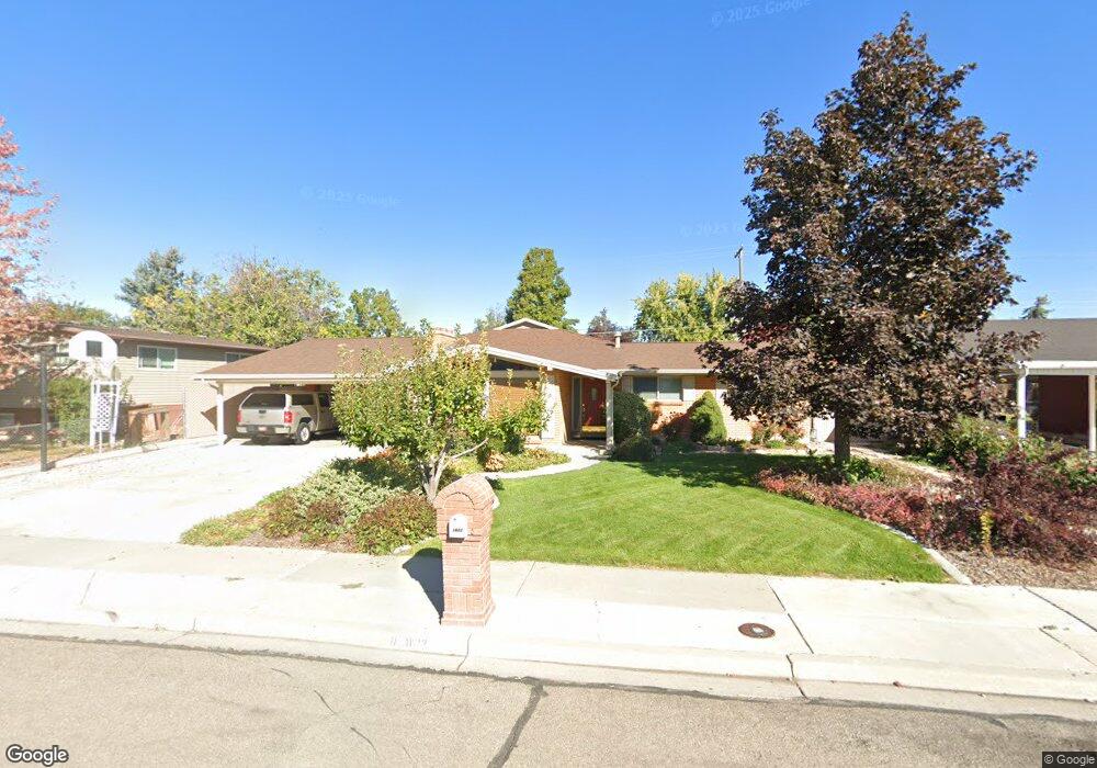
1622 W 950 N Provo, UT 84604
Grandview South NeighborhoodEstimated Value: $573,000 - $769,000
3
Beds
3
Baths
2,143
Sq Ft
$303/Sq Ft
Est. Value
About This Home
This home is located at 1622 W 950 N, Provo, UT 84604 and is currently estimated at $649,905, approximately $303 per square foot. 1622 W 950 N is a home located in Utah County with nearby schools including Westridge Elementary School, Dixon Middle School, and Provo High School.
Ownership History
Date
Name
Owned For
Owner Type
Purchase Details
Closed on
Apr 23, 2025
Sold by
Michael And Stephanie Barnes Family Trus and Barnes Michael D
Bought by
Holman William Lake
Current Estimated Value
Home Financials for this Owner
Home Financials are based on the most recent Mortgage that was taken out on this home.
Original Mortgage
$458,000
Outstanding Balance
$455,967
Interest Rate
6.65%
Mortgage Type
New Conventional
Estimated Equity
$193,938
Purchase Details
Closed on
Jan 27, 2025
Sold by
Barnes Michael D and Barnes Stephanie M
Bought by
Michael And Stephanie Barnes Family Trust and Barnes
Home Financials for this Owner
Home Financials are based on the most recent Mortgage that was taken out on this home.
Original Mortgage
$608,000
Interest Rate
6.72%
Mortgage Type
Credit Line Revolving
Purchase Details
Closed on
Mar 20, 2017
Sold by
Barnes Michael D and Barnes Stephanie M
Bought by
Barnes Michael D and Barnes Stephen M
Home Financials for this Owner
Home Financials are based on the most recent Mortgage that was taken out on this home.
Original Mortgage
$150,000
Interest Rate
4.17%
Mortgage Type
Credit Line Revolving
Purchase Details
Closed on
Mar 11, 2014
Sold by
Barnes Michael D and Barnes Stephanie M
Bought by
Michael And Stephanie Barnes Family Trus and Barnes Stephanie M
Purchase Details
Closed on
Aug 28, 1997
Sold by
Schindehette Harry M and Schindehette Jacquelyn L
Bought by
Barnes Michael D and Barnes Stephanie M
Home Financials for this Owner
Home Financials are based on the most recent Mortgage that was taken out on this home.
Original Mortgage
$138,550
Interest Rate
7.43%
Purchase Details
Closed on
Jul 31, 1996
Sold by
Francis Rulon S and Francis Geraldine Y
Bought by
Schindehette Harry M and Schindehette Jacquelyn L
Home Financials for this Owner
Home Financials are based on the most recent Mortgage that was taken out on this home.
Original Mortgage
$143,000
Interest Rate
8.32%
Create a Home Valuation Report for This Property
The Home Valuation Report is an in-depth analysis detailing your home's value as well as a comparison with similar homes in the area
Home Values in the Area
Average Home Value in this Area
Purchase History
| Date | Buyer | Sale Price | Title Company |
|---|---|---|---|
| Holman William Lake | -- | Metro National Title | |
| Michael And Stephanie Barnes Family Trust | -- | Meridian Title | |
| Barnes Michael D | -- | Meridian Title | |
| Barnes Michael D | -- | First American Title Ins | |
| Barnes Michael D | -- | First American Title Ins | |
| Michael And Stephanie Barnes Family Trus | -- | None Available | |
| Barnes Michael D | -- | -- | |
| Schindehette Harry M | -- | Provo Land Title |
Source: Public Records
Mortgage History
| Date | Status | Borrower | Loan Amount |
|---|---|---|---|
| Open | Holman William Lake | $458,000 | |
| Previous Owner | Barnes Michael D | $608,000 | |
| Previous Owner | Barnes Michael D | $150,000 | |
| Previous Owner | Barnes Michael D | $138,550 | |
| Previous Owner | Schindehette Harry M | $143,000 |
Source: Public Records
Tax History
| Year | Tax Paid | Tax Assessment Tax Assessment Total Assessment is a certain percentage of the fair market value that is determined by local assessors to be the total taxable value of land and additions on the property. | Land | Improvement |
|---|---|---|---|---|
| 2025 | $3,285 | $348,975 | -- | -- |
| 2024 | $3,285 | $323,345 | $0 | $0 |
| 2023 | $3,313 | $321,530 | $0 | $0 |
| 2022 | $2,990 | $292,545 | $0 | $0 |
| 2021 | $2,326 | $396,900 | $110,300 | $286,600 |
| 2020 | $2,241 | $358,500 | $100,300 | $258,200 |
| 2019 | $2,127 | $353,900 | $100,300 | $253,600 |
| 2018 | $1,893 | $319,400 | $93,200 | $226,200 |
| 2017 | $1,389 | $128,810 | $0 | $0 |
| 2016 | $1,420 | $122,760 | $0 | $0 |
| 2015 | $1,405 | $122,760 | $0 | $0 |
| 2014 | $1,165 | $106,095 | $0 | $0 |
Source: Public Records
Map
Nearby Homes
- 1580 W 900 N
- 925 N 1760 W
- 962 Independence Ave
- 986 Independence Ave
- 927 Independence Ave
- 1903 W 890 N
- 1234 Uinta Dr
- 1524 Merlin Dr
- 1415 Arthur Dr
- 1407 Arthur Dr
- 1441 Arthur Dr
- 1107 Independence Ave
- 1174 W 1050 N
- 1254 N 1220 W
- 1515 N 1830 W
- 1215 W 580 N
- 1525 N 1250 W
- 579 N Geneva Rd
- 630 N 1100 W
- 1058 N 1000 W
Your Personal Tour Guide
Ask me questions while you tour the home.