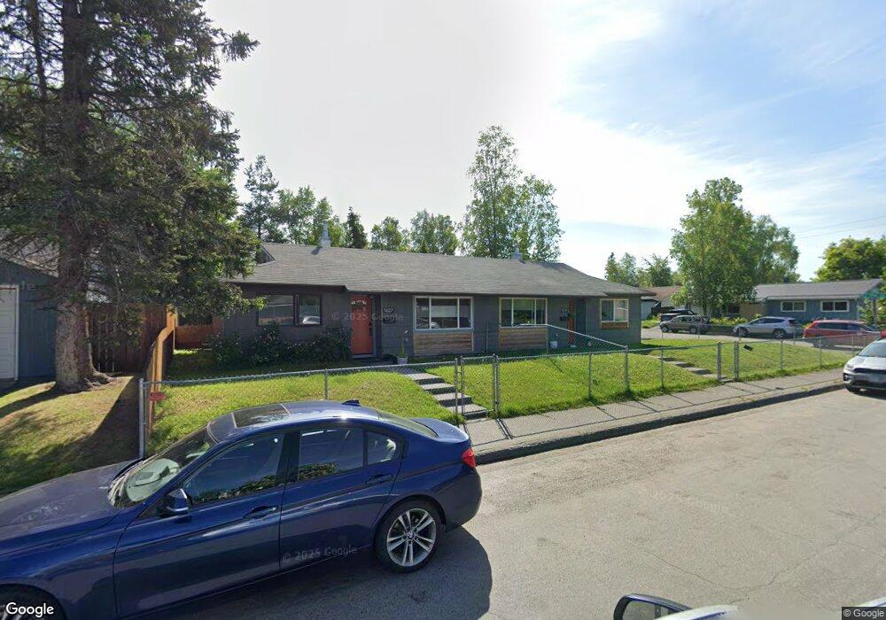
1627 Logan St Anchorage, AK 99508
Airport Heights NeighborhoodEstimated Value: $163,000 - $381,000
About This Home
Incredible location in Airport Heights across the street from Fire Island Bakery! Recent remodel on this ranch style duplex unit featuring granite countertops, LVP flooring, beautiful subway tile finishes, and stainless appliances including front load washing machine & gas dryer! Alaska Regional Hospital, Airport Heights Elementary, Tikishla Park and Chester Creek greenbelt are all within walking distance. Unit has a private fenced backyard and an unheated one car garage for storing all your Alaska outdoor toys.
Rent includes water, sewer and garbage. Tenant pays for gas and electric. Dogs allowed upon approval with $50/month additional pet rent, maximum of 1 dog allowed.
Will start showing on Friday 10/10
Application Criteria:
-Maximum 2 adult occupants
-Minimum 700 credit score
-Verifiable Income of at least 3.5x monthly rent
-No prior evictions or judgements
-Clean rental history with positive references
-No smoking or illegal activity of the property
Ownership History
We collect this data history from publicly available records. To have your information removed, we recommend requesting removal directly through your county’s website.
Purchase Details
Home Financials for this Owner
Home Financials are based on the most recent Mortgage that was taken out on this home.Home Values in the Area
Average Home Value in this Area
Purchase History
We collect this data history from publicly available records. To have your information removed, we recommend requesting removal directly through your county’s website.
| Date | Buyer | Sale Price | Title Company |
|---|---|---|---|
| -- | None Listed On Document |
Mortgage History
We collect this data history from publicly available records. To have your information removed, we recommend requesting removal directly through your county’s website.
| Date | Status | Borrower | Loan Amount |
|---|---|---|---|
| Open | $248,000 |
Property History
We collect this data history from publicly available records. To have your information removed, we recommend requesting removal directly through your county’s website.
| Date | Event | Price | List to Sale | Price per Sq Ft |
|---|---|---|---|---|
| 11/04/2025 11/04/25 | Off Market | $1,975 | -- | -- |
| 10/08/2025 10/08/25 | For Rent | $1,975 | -- | -- |
Tax History
We collect this data history from publicly available records. To have your information removed, we recommend requesting removal directly through your county’s website.
| Year | Tax Paid | Tax Assessment Tax Assessment Total Assessment is a certain percentage of the fair market value that is determined by local assessors to be the total taxable value of land and additions on the property. | Land | Improvement |
|---|---|---|---|---|
| 2025 | $3,543 | $299,400 | $89,700 | $209,700 |
| 2024 | $3,662 | $301,800 | $89,700 | $212,100 |
| 2023 | $4,821 | $283,100 | $89,700 | $193,400 |
| 2022 | $3,831 | $277,500 | $89,700 | $187,800 |
| 2021 | $4,680 | $259,700 | $89,700 | $170,000 |
| 2020 | $3,461 | $203,600 | $89,700 | $113,900 |
| 2019 | $4,039 | $246,900 | $89,700 | $157,200 |
| 2018 | $4,049 | $246,900 | $89,700 | $157,200 |
| 2017 | $3,931 | $251,000 | $89,700 | $161,300 |
| 2016 | $3,077 | $239,100 | $77,700 | $161,400 |
| 2015 | $3,077 | $231,600 | $77,700 | $153,900 |
| 2014 | $3,077 | $227,200 | $74,700 | $152,500 |
Map
- 1811 Talkeetna St
- 1436 Garden St
- 1328 Birchwood St
- 2254 Knoll Cir Unit 12
- 1804 Parkside Dr
- 2067 Eastridge Dr Unit 35
- 3215 E 18th Cir
- 1327 Airport Heights Dr
- 1524 Rosemary St
- 000 Tr A Thurston
- 2243 Sorbus Way
- 2107 Sorbus Way
- 3463 E 20th Ave Unit 34
- 2228 Sorbus Way
- 3604 E 18th Ave
- 3551 E 20th Ave
- 2615 Sorbus Cir
- 2091 Crataegus Ave
- 1704 Orca Place
- 1511 Nelchina St
- 1629 Logan St
- 2613 E 17th Ave
- 1617 Logan St
- 1617 Logan St
- 1626 Logan St
- 2623 E 17th Ave
- 2606 E 17th Ave
- 1616 Logan St
- 2614 E 17th Ave
- 2614 E 17th Ave
- 2524 E 17th Ave
- 2521 E 17th Ave
- 2633 E 17th Ave
- 1702 Aleutian St
- 1711 Logan St
- 2630 E 16th Ave
- 2520 E 17th Ave
- 2511 E 17th Ave
- 1718 Aleutian St
- 1718 Logan St
Ask me questions while you tour the home.