
Seller's Agent in 2025
Gloria Henry-Kidd
Red 1 Realty
(614) 579-8889
14 Total Sales


R13 T08 S04 BRUNER MILLER SD LOT 6, ON
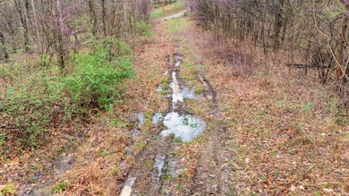
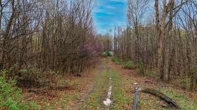
11.0430 ACRES OF VACANT LAND AVAILABLE FOR RESIDENTIAL OR AGRRICULTURE SALE, YOU DECIDE. NEIGHBORHOOD 00003000-UNION TWP.
MAP NUMBER 0001-00
ROUTING NUMBER 108-06
Include RM1-SINGLE WIDE MOBILE HOME, BLT. 1987 14X68 ON 1 ACRE. PROPERTY CONDITION FAIR, MAY NOT BE LIVABLE.
Last Agent to Sell the Property
Red 1 Realty License #370898 Listed on: 03/28/2025
| Date | Event | Price | List to Sale | Price per Sq Ft |
|---|---|---|---|---|
| 07/30/2025 07/30/25 | Sold | $50,000 | -41.5% | -- |
| 07/23/2025 07/23/25 | Pending | -- | -- | -- |
| 07/09/2025 07/09/25 | Price Changed | $85,500 | -40.4% | -- |
| 04/28/2025 04/28/25 | Price Changed | $143,500 | -6.5% | -- |
| 03/28/2025 03/28/25 | For Sale | $153,500 | -- | -- |
| Year | Tax Paid | Tax Assessment Tax Assessment Total Assessment is a certain percentage of the fair market value that is determined by local assessors to be the total taxable value of land and additions on the property. | Land | Improvement |
|---|---|---|---|---|
| 2025 | $594 | $18,430 | $14,560 | $3,870 |
| 2024 | $594 | $18,430 | $14,560 | $3,870 |
| 2023 | $596 | $16,580 | $11,870 | $4,710 |
| 2022 | $529 | $16,580 | $11,870 | $4,710 |
| 2021 | $535 | $16,580 | $11,870 | $4,710 |
| 2019 | $507 | $15,070 | $10,790 | $4,280 |
| 2018 | $488 | $15,070 | $10,790 | $4,280 |
| 2017 | $368 | $11,092 | $8,456 | $2,636 |
| 2016 | $369 | $11,092 | $8,456 | $2,636 |
| 2015 | $1,903 | $11,092 | $8,456 | $2,636 |
| 2014 | $380 | $11,092 | $8,456 | $2,636 |
| 2013 | $374 | $11,092 | $8,456 | $2,636 |
Seller's Agent in 2025
Gloria Henry-Kidd
Red 1 Realty
(614) 579-8889
14 Total Sales
Buyer's Agent in 2025
Laura VonBruenchenhein
Howard Hanna Real Estate Svcs
(815) 690-2204
67 Total Sales
Source: Columbus and Central Ohio Regional MLS
MLS Number: 225009557
Disclaimer: Certain information contained herein is derived from information provided by parties other than Homes.com. All information provided is deemed reliable, but is not guaranteed to be accurate and should be independently verified.
![]() IDX information is provided exclusively for personal, non-commercial use, and may not be used for any purpose other than to identify prospective properties consumers may be interested in purchasing.
IDX information is provided exclusively for personal, non-commercial use, and may not be used for any purpose other than to identify prospective properties consumers may be interested in purchasing.
Information is deemed reliable but not guaranteed.
Ask me questions while you tour the home.