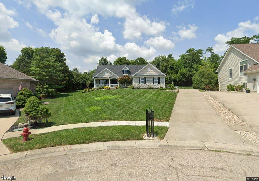
165 S Pond Ct Springboro, OH 45066
Estimated Value: $522,882 - $601,000
3
Beds
2
Baths
2,268
Sq Ft
$244/Sq Ft
Est. Value
About This Home
This home is located at 165 S Pond Ct, Springboro, OH 45066 and is currently estimated at $553,221, approximately $243 per square foot. 165 S Pond Ct is a home located in Warren County with nearby schools including Clearcreek Elementary School, Springboro Intermediate School, and Dennis Elementary School.
Ownership History
Date
Name
Owned For
Owner Type
Purchase Details
Closed on
Mar 30, 2011
Sold by
Edmunds Timothy M and Martin Selene K
Bought by
Moles Danny O and Moles Melinda W
Current Estimated Value
Home Financials for this Owner
Home Financials are based on the most recent Mortgage that was taken out on this home.
Original Mortgage
$210,000
Outstanding Balance
$143,071
Interest Rate
4.92%
Mortgage Type
New Conventional
Estimated Equity
$410,150
Purchase Details
Closed on
Aug 10, 2004
Sold by
Stoneridge Development Ltd
Bought by
Edmunds Timothy M and Edmunds Selene K
Home Financials for this Owner
Home Financials are based on the most recent Mortgage that was taken out on this home.
Original Mortgage
$326,933
Interest Rate
5.12%
Mortgage Type
Purchase Money Mortgage
Create a Home Valuation Report for This Property
The Home Valuation Report is an in-depth analysis detailing your home's value as well as a comparison with similar homes in the area
Home Values in the Area
Average Home Value in this Area
Purchase History
We collect this data history from publicly available records. To have your information removed, we recommend requesting removal directly through your county’s website.
| Date | Buyer | Sale Price | Title Company |
|---|---|---|---|
| Moles Danny O | $310,000 | Landmark Title Agency S Inc | |
| Edmunds Timothy M | $69,900 | Triad Title Agency Inc |
Source: Public Records
Mortgage History
We collect this data history from publicly available records. To have your information removed, we recommend requesting removal directly through your county’s website.
| Date | Status | Borrower | Loan Amount |
|---|---|---|---|
| Open | Moles Danny O | $210,000 | |
| Previous Owner | Edmunds Timothy M | $326,933 |
Source: Public Records
Tax History
| Year | Tax Paid | Tax Assessment Tax Assessment Total Assessment is a certain percentage of the fair market value that is determined by local assessors to be the total taxable value of land and additions on the property. | Land | Improvement |
|---|---|---|---|---|
| 2025 | $6,223 | $156,400 | $41,650 | $114,750 |
| 2024 | $6,223 | $156,400 | $41,650 | $114,750 |
| 2023 | $5,418 | $126,581 | $28,910 | $97,671 |
| 2022 | $5,418 | $126,581 | $28,910 | $97,671 |
| 2021 | $5,047 | $126,581 | $28,910 | $97,671 |
| 2020 | $4,891 | $107,272 | $24,500 | $82,772 |
| 2019 | $4,519 | $107,272 | $24,500 | $82,772 |
| 2018 | $4,420 | $107,272 | $24,500 | $82,772 |
| 2017 | $4,764 | $102,053 | $21,879 | $80,175 |
| 2016 | $4,960 | $102,053 | $21,879 | $80,175 |
| 2015 | $5,151 | $102,053 | $21,879 | $80,175 |
| 2014 | $5,151 | $102,050 | $21,880 | $80,170 |
| 2013 | $5,147 | $114,280 | $24,500 | $89,780 |
Source: Public Records
Map
Nearby Homes
- 1045 Ohio 73
- 52 Chestnut St
- 58 Chestnut St
- 55 Chestnut St
- 85 Chestnut St
- 82 Chestnut St
- 40 Chestnut St
- 46 Chestnut St
- 28 Chestnut St
- 1045 W State Route 73
- 30 Waldwick Way
- 165 Magnolia Ln
- 7545 Deer Path Ct
- 7625 Deer Path Ct
- 7277 Southview Ct
- 215 Beckley Farm Way
- 15 Shockton Ct
- 30 College Hill Terrace
- 475 Timber Walk Ct
- 1234 W Lower Springboro Rd
Your Personal Tour Guide
Ask me questions while you tour the home.