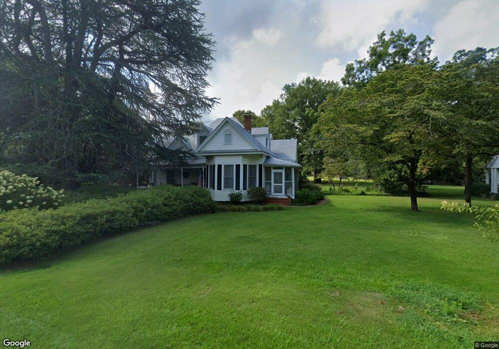
166 Davidson St Sharon, GA 30664
Estimated Value: $465,000 - $770,349
Studio
--
Bath
1,640
Sq Ft
$363/Sq Ft
Est. Value
About This Home
This home is located at 166 Davidson St, Sharon, GA 30664 and is currently estimated at $595,783, approximately $363 per square foot. 166 Davidson St is a home with nearby schools including Taliaferro County School.
Ownership History
Date
Name
Owned For
Owner Type
Purchase Details
Closed on
Aug 26, 2010
Sold by
Saggus Louise H
Bought by
Brown Renee P
Current Estimated Value
Purchase Details
Closed on
May 17, 2006
Sold by
Jacques Ceres Maximin
Bought by
Jean Astrophe Nivol and Jean Astrophe Merline Nivol
Purchase Details
Closed on
Dec 19, 2003
Sold by
Brown Renee P and Brown Lawr
Bought by
Brown Renee P
Purchase Details
Closed on
Dec 31, 1997
Sold by
Jtrs
Bought by
Brown Renee P and Brown Lawr
Create a Home Valuation Report for This Property
The Home Valuation Report is an in-depth analysis detailing your home's value as well as a comparison with similar homes in the area
Purchase History
| Date | Buyer | Sale Price | Title Company |
|---|---|---|---|
| Brown Renee P | $204,136 | -- | |
| Jean Astrophe Nivol | $5,055 | -- | |
| Jacques Edmonde F | $10,230 | -- | |
| Remy Pierrot | $5,000 | -- | |
| Ysbeck Yves Cesar | $5,165 | -- | |
| Morisset Jacques | $5,000 | -- | |
| Casimir Patrick J | $5,335 | -- | |
| Brown Renee P | -- | -- | |
| Brown Renee P | -- | -- |
Source: Public Records
Tax History
| Year | Tax Paid | Tax Assessment Tax Assessment Total Assessment is a certain percentage of the fair market value that is determined by local assessors to be the total taxable value of land and additions on the property. | Land | Improvement |
|---|---|---|---|---|
| 2025 | $4,723 | $343,324 | $237,920 | $105,404 |
| 2024 | $4,732 | $173,884 | $104,720 | $69,164 |
| 2023 | $4,684 | $173,884 | $104,720 | $69,164 |
| 2022 | $4,620 | $173,884 | $104,720 | $69,164 |
| 2021 | $4,563 | $173,884 | $104,720 | $69,164 |
| 2020 | $4,507 | $173,884 | $104,720 | $69,164 |
| 2019 | $4,443 | $173,884 | $104,720 | $69,164 |
| 2018 | $6,920 | $173,884 | $104,720 | $69,164 |
| 2017 | $4,329 | $173,884 | $104,720 | $69,164 |
| 2016 | $4,454 | $173,884 | $104,720 | $69,164 |
| 2015 | -- | $173,884 | $104,720 | $69,164 |
| 2014 | -- | $186,684 | $117,520 | $69,164 |
| 2013 | -- | $186,684 | $117,520 | $69,164 |
Source: Public Records
Map
Nearby Homes
- 0 Barnett Rd SE Unit 10701695
- 0 Barnett Rd SE Unit 552773
- 1929 Rd
- 10 Frank Smith Rd
- 0 Williams Creek Church Rd Unit 26433643
- 000 Lower Mill Rd NE
- 0 Lower Mill Rd NE Unit 10668896
- 0 Lower Mill Rd NE Unit 10713004
- 0 Lower Mill Rd NE Unit 10668849
- 00 Lower Mill Rd NE
- 0 Lower Mill Rd NE Unit 7701529
- 3445 Silas Mercer Rd NE
- 1000 Old Sandy Cross Rd
- 3678 Lundberg Rd
- 0 Saggus Rd Unit 10580223
- 4316 Sharon Rd
- 0 Silas Mercer Rd NE Unit 10364766
- 1360 Evans Rd
- 115 Moore St SW
- 118 Alexander St
- 184 Davidson St SE
- 228 Davidson St SE
- 140 Raytown Rd NE
- 146 Barnett Rd SE
- 137 Ray Ave NE
- 114 Barnett Rd SE
- 284 Barnett Rd SE
- LOT 24 Tomlin Rd
- 162 Raytown Rd NE
- 171 Hillman Rd
- 124 Crawfordville
- 134 Barnett Rd
- 133 Raytown Rd NE
- 161 Raytown Rd NE
- 4020 Locust Grove Rd NE
- 213 Davidson St SE
- 266 Sharon St
- 240 Raytown Rd NE
- 165 Washington Rd NE
- 154 Kendricks Mill Rd NW
Your Personal Tour Guide
Ask me questions while you tour the home.