
Seller's Agent in 2025
Chris Futvoye
Lake Homes Realty
(256) 338-5574
69 Total Sales


Estimated Value: $235,832 - $279,000
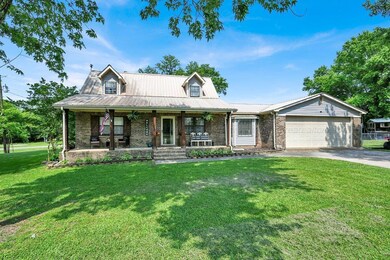
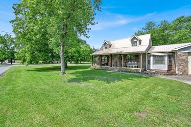
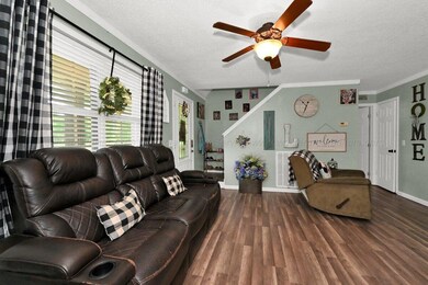
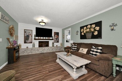
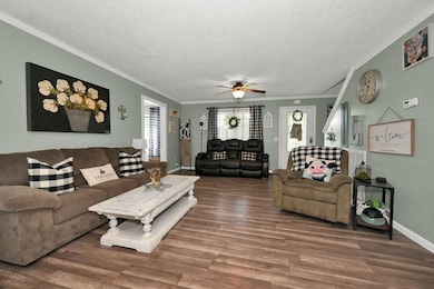
Charming 4-bedroom, 2.5-bath Craftsman-style farmhouse on a spacious corner lot with fenced backyard and attached 2-car garage. This beautifully updated home features modern flooring, renovated bathrooms, and a stunning kitchen with butcher block countertops and ample cabinet space. Enjoy cozy evenings by the wood-burning fireplace in the inviting living area. The open layout offers a perfect blend of classic charm and contemporary comfort. Located just minutes from schools, shops, and other amenities, this home combines the tranquility of a farmhouse feel with city convenience. The fenced yard is ideal for entertaining, pets, or play. Don't miss this move-in-ready gem that captures both style and functionality.
Last Agent to Sell the Property
Lake Homes Realty License #108542 Listed on: 06/03/2025
Last Buyer's Agent
Non Member
Non - Board Member
We collect this data history from publicly available records. To have your information removed, we recommend requesting removal directly through your county’s website.
| Date | Buyer | Sale Price | Title Company |
|---|---|---|---|
| Boice Casey | $249,000 | None Listed On Document | |
| Boice Casey | $249,000 | None Listed On Document | |
| Lee Jessie | $156,000 | None Available | |
| Rice Dustin G | $110,000 | -- |
We collect this data history from publicly available records. To have your information removed, we recommend requesting removal directly through your county’s website.
| Date | Status | Borrower | Loan Amount |
|---|---|---|---|
| Open | Boice Casey | $249,000 | |
| Closed | Boice Casey | $249,000 | |
| Previous Owner | Lee Jessie | $156,000 | |
| Previous Owner | Rice Dustin G | $109,966 |
| Date | Event | Price | List to Sale | Price per Sq Ft |
|---|---|---|---|---|
| 07/25/2025 07/25/25 | Sold | $249,000 | -0.4% | $124 / Sq Ft |
| 06/18/2025 06/18/25 | Price Changed | $249,900 | -3.8% | $124 / Sq Ft |
| 06/03/2025 06/03/25 | For Sale | $259,900 | -- | $129 / Sq Ft |
| Year | Tax Paid | Tax Assessment Tax Assessment Total Assessment is a certain percentage of the fair market value that is determined by local assessors to be the total taxable value of land and additions on the property. | Land | Improvement |
|---|---|---|---|---|
| 2025 | -- | $14,060 | $0 | $0 |
| 2024 | -- | $14,060 | $0 | $0 |
| 2023 | $0 | $13,780 | $0 | $0 |
| 2022 | $0 | $12,440 | $0 | $0 |
| 2021 | $380 | $25,500 | $0 | $0 |
| 2020 | $337 | $11,440 | $0 | $0 |
| 2019 | $337 | $11,440 | $0 | $0 |
| 2018 | $330 | $11,240 | $0 | $0 |
| 2017 | $307 | $112,400 | $0 | $0 |
| 2016 | $307 | $112,400 | $0 | $0 |
| 2015 | $299 | $109,560 | $0 | $0 |
| 2014 | $303 | $111,020 | $0 | $0 |
| 2013 | -- | $111,020 | $0 | $0 |
Seller's Agent in 2025
Chris Futvoye
Lake Homes Realty
(256) 338-5574
69 Total Sales
N
Buyer's Agent in 2025
Non Member
Non - Board Member
Source: Walker Area Association of REALTORS®
MLS Number: 25-1123
APN: 67 10 02 04 0 200 054.001
Ask me questions while you tour the home.