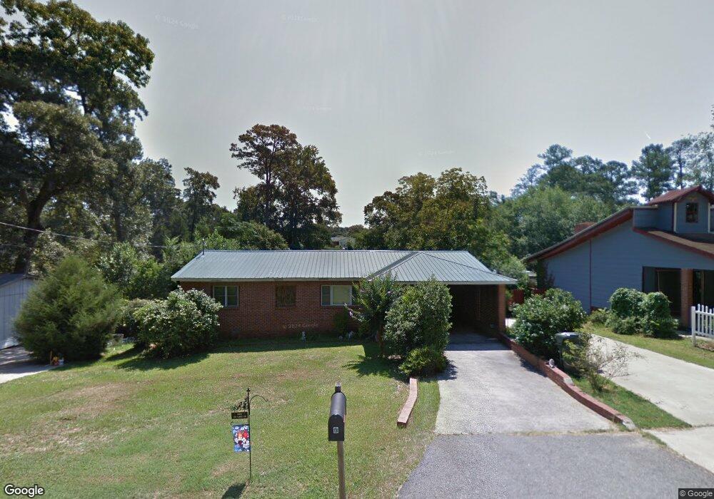
169 Carter Cir Warner Robins, GA 31093
Centerville AreaEstimated Value: $109,000 - $144,102
About This Home
This home is located at 169 Carter Cir, Warner Robins, GA 31093 and is currently estimated at $125,276, approximately $99 per square foot. 169 Carter Cir is a home located in Houston County with nearby schools including Westside Elementary School, Northside Middle School, and Northside High School.
Ownership History
We collect this data history from publicly available records. To have your information removed, we recommend requesting removal directly through your county’s website.
Purchase Details
Purchase Details
Purchase Details
Purchase Details
Home Values in the Area
Average Home Value in this Area
Purchase History
We collect this data history from publicly available records. To have your information removed, we recommend requesting removal directly through your county’s website.
| Date | Buyer | Sale Price | Title Company |
|---|---|---|---|
| $30,000 | -- | ||
| -- | -- | ||
| -- | -- | ||
| -- | -- |
Tax History
We collect this data history from publicly available records. To have your information removed, we recommend requesting removal directly through your county’s website.
| Year | Tax Paid | Tax Assessment Tax Assessment Total Assessment is a certain percentage of the fair market value that is determined by local assessors to be the total taxable value of land and additions on the property. | Land | Improvement |
|---|---|---|---|---|
| 2025 | $712 | $36,160 | $6,200 | $29,960 |
| 2024 | $737 | $32,800 | $6,200 | $26,600 |
| 2023 | $576 | $25,840 | $3,280 | $22,560 |
| 2022 | $575 | $25,800 | $3,280 | $22,520 |
| 2021 | $506 | $22,840 | $3,280 | $19,560 |
| 2020 | $554 | $22,640 | $3,280 | $19,360 |
| 2019 | $504 | $22,640 | $3,280 | $19,360 |
| 2018 | $504 | $22,640 | $3,280 | $19,360 |
| 2017 | $504 | $22,640 | $3,280 | $19,360 |
| 2016 | $505 | $22,640 | $3,280 | $19,360 |
| 2015 | $506 | $22,640 | $3,280 | $19,360 |
| 2014 | -- | $22,640 | $3,280 | $19,360 |
| 2013 | -- | $26,880 | $3,280 | $23,600 |
Map
- 121 Napier Ave
- 103 Jaybee Dr
- 112 Holt Ave
- 1728 Green St
- 106 Westcliff Cir Unit C
- 132 Sussex Dr
- 217 Wray St
- 102 Hemlock St
- 103 Westcliff Cir Unit A
- 103 Westcliff Cir Unit A
- 221 Gilchrist Dr
- 109 Delchamps Dr
- 141 Peacock Dr
- 111 Laurel Oak Ln
- 108 Laurel Oak Ln
- 115 Foxfire Dr
- 138 Woodcrest Cir
- 111 Foxfire Dr
- 66 Hamilton Woods Ct
- 123 S Amanda Place
- 171 Carter Cir
- 167 Carter Cir
- 173 Carter Cir
- 165 Carter Cir
- 121 Carter Cir
- 121 Carter Cir Unit 123 Carter Circle
- 170 Carter Cir
- 168 Carter Cir
- 166 Carter Cir
- 174 Carter Cir
- 127 Carter Cir
- 164 Carter Cir
- 117 Carter Cir
- 164 Carter Cir
- 120 Carter Cir
- 129 Carter Cir
- 176 Carter Cir
- 181 Carter Cir
- 114 Fisher St
- 160 Carter Cir
Ask me questions while you tour the home.