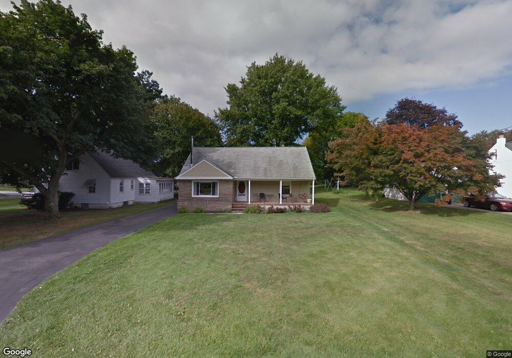
170 Lee Rd Painesville, OH 44077
Estimated Value: $201,000 - $236,000
4
Beds
1
Bath
1,178
Sq Ft
$182/Sq Ft
Est. Value
About This Home
This home is located at 170 Lee Rd, Painesville, OH 44077 and is currently estimated at $214,482, approximately $182 per square foot. 170 Lee Rd is a home located in Lake County with nearby schools including Henry F. Lamuth Middle School, Riverside Junior/Senior High School, and Summit Academy Community School - Painesville.
Ownership History
Date
Name
Owned For
Owner Type
Purchase Details
Closed on
May 13, 2022
Sold by
Sleme Frank J and Sleme Shirley A
Bought by
Slemc Frank J and Slemc Shirley A
Current Estimated Value
Home Financials for this Owner
Home Financials are based on the most recent Mortgage that was taken out on this home.
Original Mortgage
$152,000
Outstanding Balance
$143,010
Interest Rate
4.72%
Mortgage Type
New Conventional
Estimated Equity
$71,472
Purchase Details
Closed on
May 15, 2003
Sold by
Will Of Stanley Majka and Medema Rose Marie
Bought by
Slemc Frank J
Home Financials for this Owner
Home Financials are based on the most recent Mortgage that was taken out on this home.
Original Mortgage
$126,000
Interest Rate
6.87%
Mortgage Type
Purchase Money Mortgage
Purchase Details
Closed on
Mar 20, 1985
Bought by
Majka Stanley
Create a Home Valuation Report for This Property
The Home Valuation Report is an in-depth analysis detailing your home's value as well as a comparison with similar homes in the area
Home Values in the Area
Average Home Value in this Area
Purchase History
| Date | Buyer | Sale Price | Title Company |
|---|---|---|---|
| Slemc Frank J | -- | Pearl Law Offices Llc | |
| Slemc Frank J | $124,000 | Chicago Title Insurance Comp | |
| Majka Stanley | -- | -- |
Source: Public Records
Mortgage History
| Date | Status | Borrower | Loan Amount |
|---|---|---|---|
| Open | Slemc Frank J | $152,000 | |
| Previous Owner | Slemc Frank J | $126,000 |
Source: Public Records
Tax History
| Year | Tax Paid | Tax Assessment Tax Assessment Total Assessment is a certain percentage of the fair market value that is determined by local assessors to be the total taxable value of land and additions on the property. | Land | Improvement |
|---|---|---|---|---|
| 2025 | -- | $63,040 | $13,640 | $49,400 |
| 2024 | -- | $63,040 | $13,640 | $49,400 |
| 2023 | $4,812 | $44,160 | $9,900 | $34,260 |
| 2022 | $2,638 | $44,160 | $9,900 | $34,260 |
| 2021 | $2,648 | $44,160 | $9,900 | $34,260 |
| 2020 | $2,872 | $38,400 | $8,610 | $29,790 |
| 2019 | $2,628 | $38,400 | $8,610 | $29,790 |
| 2018 | $2,638 | $31,910 | $7,920 | $23,990 |
| 2017 | $2,471 | $31,910 | $7,920 | $23,990 |
| 2016 | $2,207 | $31,910 | $7,920 | $23,990 |
| 2015 | $1,828 | $31,910 | $7,920 | $23,990 |
| 2014 | $1,858 | $31,910 | $7,920 | $23,990 |
| 2013 | $1,816 | $31,910 | $7,920 | $23,990 |
Source: Public Records
Map
Nearby Homes
- 575 Park Rd
- 592 Sand Trap Cir
- 375 Golfway Dr
- 1598 Bogie Ln
- 399 Sandtrap Cir
- 4 Lyndale Dr
- 396 Park Rd
- 556 Greenside Dr
- 300 Manhattan Pkwy
- V/L Morgan Dr
- 140 Parkhall Dr
- 2041 Marsh Ln Unit 2041
- 264 Park Rd
- 594 Prestwick Path
- 726 N Creek Dr
- 94 Bowhall Rd
- 783 Outrigger Cove
- 67 Tanners Farm Dr
- 983 Tradewinds Cove Unit 4A
- 1638 Madison Ave
Your Personal Tour Guide
Ask me questions while you tour the home.