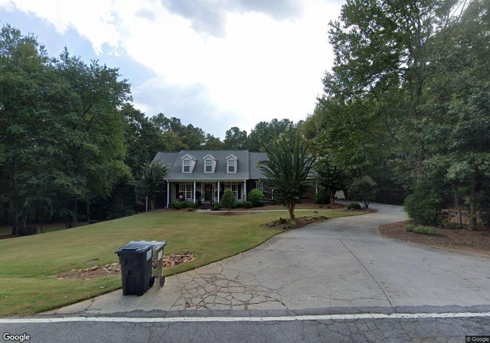
175 Nugget Rd Carrollton, GA 30117
Estimated Value: $449,000 - $587,000
3
Beds
3
Baths
2,927
Sq Ft
$180/Sq Ft
Est. Value
About This Home
This home is located at 175 Nugget Rd, Carrollton, GA 30117 and is currently estimated at $526,491, approximately $179 per square foot. 175 Nugget Rd is a home located in Carroll County with nearby schools including Roopville Elementary School, Central Middle School, and Central High School.
Ownership History
Date
Name
Owned For
Owner Type
Purchase Details
Closed on
Mar 7, 2014
Sold by
Turner Bryant R and Turner Elizabeth W
Bought by
Turner Bryant R and Turner Elizabeth W
Current Estimated Value
Purchase Details
Closed on
Aug 22, 2003
Sold by
Marshall Verlon and Marshall El
Bought by
Turner Ii Bryant R and Turner Elizabeth W
Purchase Details
Closed on
Jun 7, 1996
Bought by
Marshall Verlon and Marshall El
Create a Home Valuation Report for This Property
The Home Valuation Report is an in-depth analysis detailing your home's value as well as a comparison with similar homes in the area
Home Values in the Area
Average Home Value in this Area
Purchase History
| Date | Buyer | Sale Price | Title Company |
|---|---|---|---|
| Turner Bryant R | -- | -- | |
| Turner Ii Bryant R | $13,500 | -- | |
| Marshall Verlon | $3,800 | -- |
Source: Public Records
Tax History
| Year | Tax Paid | Tax Assessment Tax Assessment Total Assessment is a certain percentage of the fair market value that is determined by local assessors to be the total taxable value of land and additions on the property. | Land | Improvement |
|---|---|---|---|---|
| 2025 | $4,177 | $224,207 | $4,320 | $219,887 |
| 2024 | $4,224 | $224,207 | $4,320 | $219,887 |
| 2023 | $4,224 | $205,902 | $4,320 | $201,582 |
| 2022 | $2,962 | $129,472 | $4,320 | $125,152 |
| 2021 | $3,031 | $129,472 | $4,320 | $125,152 |
| 2020 | $3,596 | $135,568 | $4,320 | $131,248 |
| 2019 | $2,948 | $127,905 | $4,320 | $123,585 |
| 2018 | $2,745 | $112,164 | $4,320 | $107,844 |
| 2017 | $2,752 | $112,164 | $4,320 | $107,844 |
| 2016 | $2,506 | $102,756 | $4,320 | $98,436 |
| 2015 | $2,070 | $78,006 | $6,800 | $71,207 |
| 2014 | $2,078 | $78,007 | $6,800 | $71,207 |
Source: Public Records
Map
Nearby Homes
- 115 Nugget Rd
- 195 Gold Dust Trail
- 191 Tumlin Creek Rd
- 265 Mashburn Rd
- 0 Bonner Goldmine Rd Unit 36
- 0 Bonner Goldmine Rd Unit 10721026
- 1575 Bethesda Church Rd
- 1593 Bethesda Church Rd
- 465 Bethesda Church Rd
- 101 Southbend Dr
- 2492 Oak Grove Church Rd
- 315 Laurel Rd
- 0 John Henry Cir Unit 1530511
- 301 E Highway 5
- 0 Lowell Rd Unit 10706930
- 712 W Highway 5
- 126 Woodford Dr
- 305 West Dr
- 98 Sweetbriar Ln
- 0 Needmore Rd Unit (345 37 Acres)
- 155 Nugget Rd
- 791 Bonner Goldmine Rd
- 168 Nugget Rd
- 142 Nugget Rd
- 795 Bonner Goldmine Rd
- 200 Nugget Rd
- 825 Bonner Goldmine Rd
- 124 Nugget Rd
- 870 Bonner Goldmine Rd
- 830 Bonner Goldmine Rd
- 100 Nugget Rd
- 141 Nugget Rd Unit 67
- 141 Nugget Rd
- 185 Gold Dust Trail
- 2190 Oak Grove Rd
- 302 Nugget Rd
- 195 Gold Dust Trail Unit 7
- 72 Nugget Rd
- 2200 Oak Grove Rd
- 175 Gold Dust Trail
Your Personal Tour Guide
Ask me questions while you tour the home.