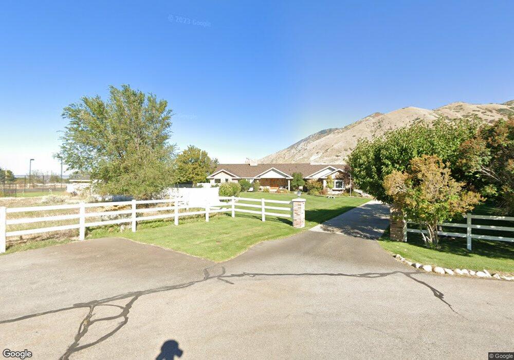
1757 N 1770 E Mapleton, UT 84664
Estimated Value: $1,012,000 - $1,349,872
4
Beds
4
Baths
4,626
Sq Ft
$261/Sq Ft
Est. Value
About This Home
This home is located at 1757 N 1770 E, Mapleton, UT 84664 and is currently estimated at $1,206,218, approximately $260 per square foot. 1757 N 1770 E is a home located in Utah County with nearby schools including Hobble Creek School, Mapleton Junior High School, and Maple Mountain High School.
Ownership History
Date
Name
Owned For
Owner Type
Purchase Details
Closed on
Nov 6, 2019
Sold by
Blanchard Georgia
Bought by
Blanchard Georgia and The Georgia Blanchard Trust
Current Estimated Value
Purchase Details
Closed on
Jul 10, 2013
Sold by
Mclff E Bruce
Bought by
Blanchard Georgia
Purchase Details
Closed on
Aug 30, 2002
Sold by
Bartok Peter Dennis
Bought by
Blanchard Georgia and Blanchard Bruce Mciff
Purchase Details
Closed on
Apr 28, 1998
Sold by
Ainge Kenneth E and Ainge Barbara
Bought by
Bartok Peter Dennis
Home Financials for this Owner
Home Financials are based on the most recent Mortgage that was taken out on this home.
Original Mortgage
$399,900
Interest Rate
7.06%
Create a Home Valuation Report for This Property
The Home Valuation Report is an in-depth analysis detailing your home's value as well as a comparison with similar homes in the area
Home Values in the Area
Average Home Value in this Area
Purchase History
| Date | Buyer | Sale Price | Title Company |
|---|---|---|---|
| Blanchard Georgia | -- | None Available | |
| Blanchard Georgia | -- | None Available | |
| Blanchard Georgia | -- | First American Title Co | |
| Bartok Peter Dennis | -- | First American Title |
Source: Public Records
Mortgage History
| Date | Status | Borrower | Loan Amount |
|---|---|---|---|
| Previous Owner | Bartok Peter Dennis | $399,900 |
Source: Public Records
Tax History
| Year | Tax Paid | Tax Assessment Tax Assessment Total Assessment is a certain percentage of the fair market value that is determined by local assessors to be the total taxable value of land and additions on the property. | Land | Improvement |
|---|---|---|---|---|
| 2025 | $6,621 | $682,300 | -- | -- |
| 2024 | $6,621 | $648,565 | $0 | $0 |
| 2023 | $6,782 | $668,530 | $0 | $0 |
| 2022 | $7,759 | $1,205,800 | $613,100 | $592,700 |
| 2021 | $6,367 | $840,000 | $384,100 | $455,900 |
| 2020 | $6,125 | $788,400 | $350,000 | $438,400 |
| 2019 | $5,797 | $758,400 | $320,000 | $438,400 |
| 2018 | $5,763 | $730,900 | $292,500 | $438,400 |
| 2017 | $5,295 | $395,250 | $0 | $0 |
| 2016 | $5,225 | $387,750 | $0 | $0 |
| 2015 | $4,702 | $346,770 | $0 | $0 |
| 2014 | $3,805 | $275,575 | $0 | $0 |
Source: Public Records
Map
Nearby Homes
- 24 Quiet Meadow Ln
- 1564 N 1700 East St
- 2881 Thirty Oaks Dr Unit 6
- 2881 Thirty Oaks Dr
- 1548 N 1350 St E Unit 11
- 1578 N 1350 St E Unit 12
- 1447 N 1350 St E Unit 5
- 1577 N 1350 St E Unit 1
- 1477 N 1350 St E Unit 4
- 1547 N 1350 St E Unit 2
- 1511 N 1350 St E Unit 3
- 1052 Cove Dr
- 2541 Stonebury Loop Rd
- 1096 N 1000 E
- 764 N 2000 E
- 829 S 2200 E
- 702 N 2000 E Unit 305
- 1567 N 600 E Unit 26
- 630 N 1600 E
- 1096 Valley Sage Dr
- 1754 N 1770 E
- 1756 N 1600 E
- 1753 E 1600 N
- 1664 N 1770 E
- 1662 N 1575 E Unit 4
- 1815 N 2000 E
- 1925 N 2000 E
- 1661 N 2000 E
- 1999 N 2000 E
- 2814 E 1100 S Unit 24
- 2814 River Bottom Rd Unit 24
- 2814 E 1100 S
- 1553 N 1700 E
- 1776 E 1600 N
- 2762 E 1100 S Unit 23
- 1565 E 1600 N
- 1700 N 2000 E
- 1660 N 2000 E
- 2738 E 1100 S Unit 22
- 2738 E 1100 S
Your Personal Tour Guide
Ask me questions while you tour the home.