Estimated Value: $351,223 - $386,000
3
Beds
2
Baths
1,824
Sq Ft
$202/Sq Ft
Est. Value
About This Home
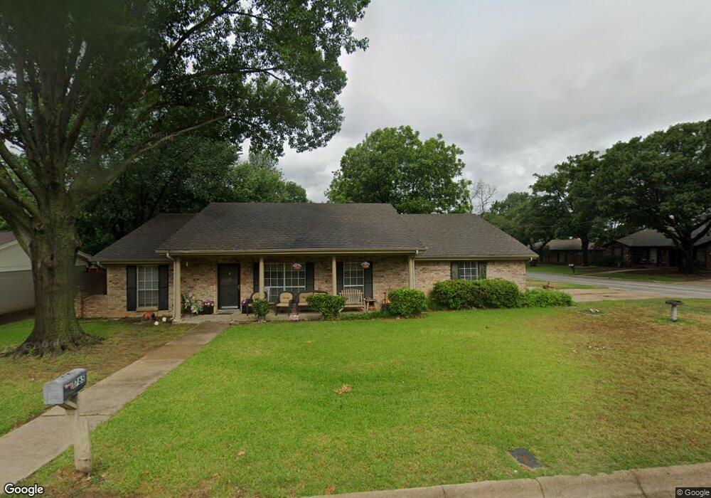
This home is located at 1765 Acorn Ln, Hurst, TX 76054 and is currently estimated at $368,056, approximately $201 per square foot. 1765 Acorn Ln is a home located in Tarrant County with nearby schools including Shady Oaks Elementary School, Bedford Junior High School, and L.D. Bell High School.
Ownership History
Date
Name
Owned For
Owner Type
Purchase Details
Closed on
Jul 30, 2010
Sold by
Mar Shale Equity Llc
Bought by
Tusa Mark D and Tusa Cindy L
Current Estimated Value
Home Financials for this Owner
Home Financials are based on the most recent Mortgage that was taken out on this home.
Original Mortgage
$150,473
Outstanding Balance
$104,188
Interest Rate
5.5%
Mortgage Type
FHA
Estimated Equity
$263,868
Purchase Details
Closed on
Dec 21, 2009
Sold by
Love Karen L
Bought by
Mar Shale Equity Llc
Home Financials for this Owner
Home Financials are based on the most recent Mortgage that was taken out on this home.
Original Mortgage
$70,800
Interest Rate
4.9%
Mortgage Type
Purchase Money Mortgage
Create a Home Valuation Report for This Property
The Home Valuation Report is an in-depth analysis detailing your home's value as well as a comparison with similar homes in the area
Home Values in the Area
Average Home Value in this Area
Purchase History
We collect this data history from publicly available records. To have your information removed, we recommend requesting removal directly through your county’s website.
| Date | Buyer | Sale Price | Title Company |
|---|---|---|---|
| Tusa Mark D | -- | Commerce Title Co | |
| Mar Shale Equity Llc | -- | Rattikin Title |
Source: Public Records
Mortgage History
We collect this data history from publicly available records. To have your information removed, we recommend requesting removal directly through your county’s website.
| Date | Status | Borrower | Loan Amount |
|---|---|---|---|
| Open | Tusa Mark D | $150,473 | |
| Previous Owner | Mar Shale Equity Llc | $70,800 |
Source: Public Records
Tax History
| Year | Tax Paid | Tax Assessment Tax Assessment Total Assessment is a certain percentage of the fair market value that is determined by local assessors to be the total taxable value of land and additions on the property. | Land | Improvement |
|---|---|---|---|---|
| 2025 | $4,018 | $337,047 | $75,000 | $262,047 |
| 2024 | $4,018 | $337,047 | $75,000 | $262,047 |
| 2023 | $6,151 | $307,692 | $55,000 | $252,692 |
| 2022 | $6,426 | $295,983 | $55,000 | $240,983 |
| 2021 | $6,119 | $253,732 | $55,000 | $198,732 |
| 2020 | $5,665 | $262,070 | $55,000 | $207,070 |
| 2019 | $5,239 | $273,273 | $55,000 | $218,273 |
| 2018 | $4,155 | $194,592 | $55,000 | $139,592 |
| 2017 | $4,477 | $213,507 | $40,000 | $173,507 |
| 2016 | $4,070 | $183,465 | $40,000 | $143,465 |
| 2015 | $3,382 | $146,200 | $17,000 | $129,200 |
| 2014 | $3,382 | $146,200 | $17,000 | $129,200 |
Source: Public Records
Map
Nearby Homes
- 1760 Acorn Ln
- 1716 Cynthia Ln
- 217 E Louella Dr
- 2809 Greg Dr
- 1705 Louella Ct
- 1617 Westridge Dr
- 2428 Stonegate Dr N
- 1620 Brown Trail
- 848 Birdsong
- 3006 Wayside Dr
- 1608 Brown Trail
- 410 Carolyn Dr
- 215 Mountainview Dr
- 200 Hillview Dr
- 205 Circleview Dr N
- 305 Chantilly Ct
- 100 W Pleasantview Dr
- 901 Shady Creek Ln
- 2304 Shady Brook Dr
- 2036 Parkridge Ct
- 1760 Northridge Dr
- 1756 Northridge Dr
- 1764 Northridge Dr
- 1761 Acorn Ln
- 1757 Acorn Ln
- 1752 Northridge Dr
- 1761 Northridge Dr
- 1757 Northridge Dr
- 1765 Northridge Dr
- 1753 Acorn Ln
- 1753 Northridge Dr
- 1748 Northridge Dr
- 204 Shady Lake Dr
- 1749 Acorn Ln
- 1760 Renee Dr
- 1756 Acorn Ln
- 1749 Northridge Dr
- 1756 Renee Dr
- 1764 Renee Dr
- 1764 Acorn Ln
Your Personal Tour Guide
Ask me questions while you tour the home.