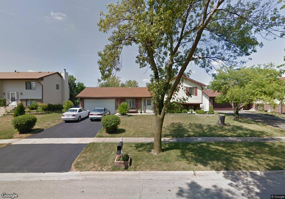
1770 Windward Ln Hanover Park, IL 60133
South Tri Village NeighborhoodEstimated Value: $300,000 - $395,000
3
Beds
3
Baths
1,510
Sq Ft
$235/Sq Ft
Est. Value
About This Home
This home is located at 1770 Windward Ln, Hanover Park, IL 60133 and is currently estimated at $355,068, approximately $235 per square foot. 1770 Windward Ln is a home located in DuPage County with nearby schools including Elsie C. Johnson Elementary School, Stratford Middle School, and Glenbard North High School.
Ownership History
Date
Name
Owned For
Owner Type
Purchase Details
Closed on
Sep 30, 1998
Sold by
Him Chea and Khim Vanny
Bought by
Him Chea and Khim Vanny
Current Estimated Value
Purchase Details
Closed on
Nov 15, 1996
Sold by
Bingham Eric A and Bingham Lisa A
Bought by
Him Chea and Khim Vanny
Home Financials for this Owner
Home Financials are based on the most recent Mortgage that was taken out on this home.
Original Mortgage
$110,000
Outstanding Balance
$10,669
Interest Rate
7.91%
Estimated Equity
$344,399
Create a Home Valuation Report for This Property
The Home Valuation Report is an in-depth analysis detailing your home's value as well as a comparison with similar homes in the area
Home Values in the Area
Average Home Value in this Area
Purchase History
We collect this data history from publicly available records. To have your information removed, we recommend requesting removal directly through your county’s website.
| Date | Buyer | Sale Price | Title Company |
|---|---|---|---|
| Him Chea | -- | -- | |
| Him Chea | $133,000 | Heritage Title Co |
Source: Public Records
Mortgage History
We collect this data history from publicly available records. To have your information removed, we recommend requesting removal directly through your county’s website.
| Date | Status | Borrower | Loan Amount |
|---|---|---|---|
| Open | Him Chea | $110,000 |
Source: Public Records
Tax History
| Year | Tax Paid | Tax Assessment Tax Assessment Total Assessment is a certain percentage of the fair market value that is determined by local assessors to be the total taxable value of land and additions on the property. | Land | Improvement |
|---|---|---|---|---|
| 2024 | $8,120 | $103,695 | $31,798 | $71,897 |
| 2023 | $5,930 | $94,080 | $28,850 | $65,230 |
| 2022 | $6,697 | $87,430 | $26,810 | $60,620 |
| 2021 | $6,806 | $83,000 | $25,450 | $57,550 |
| 2020 | $6,885 | $80,510 | $24,690 | $55,820 |
| 2019 | $6,911 | $77,640 | $23,810 | $53,830 |
| 2018 | $6,605 | $72,130 | $22,120 | $50,010 |
| 2017 | $6,519 | $69,260 | $21,240 | $48,020 |
| 2016 | $6,980 | $66,160 | $20,290 | $45,870 |
| 2015 | $6,827 | $60,800 | $18,650 | $42,150 |
| 2014 | $6,597 | $59,260 | $18,180 | $41,080 |
| 2013 | $6,536 | $60,680 | $18,620 | $42,060 |
Source: Public Records
Map
Nearby Homes
- 427 W Army Trail Rd
- 429 W Army Trail Rd
- 415 W Army Trail Rd
- 1334 Coldspring Rd Unit 203
- 3895 Clipper Dr
- 2068 Leeward Ln
- 1475 Merrimac Ln N
- 1849 Pastoral Ln
- 1990 Wildwood Ln
- 1390 Merrimac Ln N
- 1085 Rockport Dr Unit 57
- 1868 Pastoral Ln
- 605 Kingsbridge Dr Unit 10D
- 1194 Scott Ct Unit 6C
- 1192 Scott Ct
- 1901 Pastoral Ln
- 2080 Pennsbury Ln
- 3915 Greenbay Dr
- 4453 Bell Ln
- 4425 Castlebar Ln
- 1760 Windward Ln
- 1780 Windward Ln
- 3920 Seaview Dr
- 3925 Jefferson St
- 3925 County Farm Rd
- 1775 Windward Ln
- 1765 Windward Ln
- 1785 Windward Ln
- 3930 Seaview Dr
- 3935 Jefferson St
- 3935 County Farm Rd
- 3905 Seaview Dr
- 3895 Seaview Dr
- 3915 Seaview Dr
- 3925 Seaview Dr
- 3885 Seaview Dr
- 3940 Seaview Dr
- 3945 Jefferson St
- 3860 Seaview Dr
- 1821 Whaler Ln
Your Personal Tour Guide
Ask me questions while you tour the home.