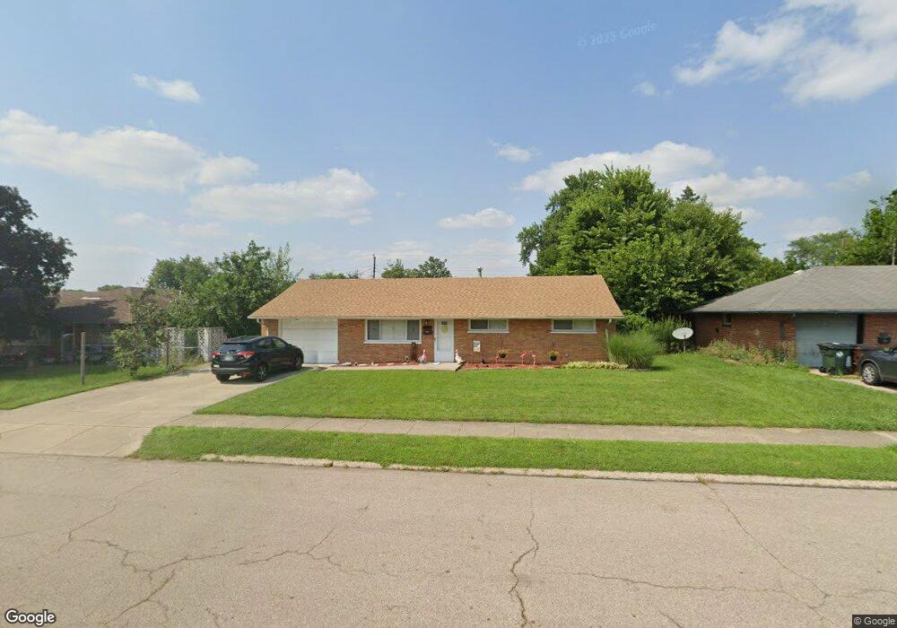
1773 W Stroop Rd Dayton, OH 45439
Estimated Value: $162,810 - $188,000
3
Beds
1
Bath
1,040
Sq Ft
$172/Sq Ft
Est. Value
About This Home
This home is located at 1773 W Stroop Rd, Dayton, OH 45439 and is currently estimated at $179,203, approximately $172 per square foot. 1773 W Stroop Rd is a home located in Montgomery County with nearby schools including Southdale Elementary School, Van Buren Middle School, and Kettering Fairmont High School.
Ownership History
Date
Name
Owned For
Owner Type
Purchase Details
Closed on
Apr 24, 2017
Sold by
Cavin Katherine M
Bought by
1773 W Stroop Llc
Current Estimated Value
Purchase Details
Closed on
Jan 7, 2013
Sold by
Fritzsche Gerald A
Bought by
Cavin Scott D and Cavin Katherine M
Purchase Details
Closed on
Jan 3, 2007
Sold by
Estate Of Walter O Fritzsche Jr
Bought by
Fritzsche Gerald A
Purchase Details
Closed on
Nov 14, 2006
Sold by
Fritzsche Lucila J
Bought by
Fritzsche Gerald A and Walter O Fritzsche Jr Revocable Living T
Purchase Details
Closed on
Sep 19, 1996
Sold by
Hobbs Jack A
Bought by
Hobbs Dane A
Create a Home Valuation Report for This Property
The Home Valuation Report is an in-depth analysis detailing your home's value as well as a comparison with similar homes in the area
Home Values in the Area
Average Home Value in this Area
Purchase History
| Date | Buyer | Sale Price | Title Company |
|---|---|---|---|
| 1773 W Stroop Llc | -- | None Available | |
| Cavin Scott D | $42,500 | None Available | |
| Fritzsche Gerald A | -- | None Available | |
| Fritzsche Gerald A | -- | Attorney | |
| Hobbs Dane A | -- | -- |
Source: Public Records
Tax History
| Year | Tax Paid | Tax Assessment Tax Assessment Total Assessment is a certain percentage of the fair market value that is determined by local assessors to be the total taxable value of land and additions on the property. | Land | Improvement |
|---|---|---|---|---|
| 2025 | $2,769 | $42,220 | $10,850 | $31,370 |
| 2024 | $2,693 | $42,220 | $10,850 | $31,370 |
| 2023 | $2,693 | $42,220 | $10,850 | $31,370 |
| 2022 | $2,206 | $27,290 | $7,000 | $20,290 |
| 2021 | $2,046 | $27,290 | $7,000 | $20,290 |
| 2020 | $2,052 | $27,290 | $7,000 | $20,290 |
| 2019 | $2,215 | $26,090 | $7,000 | $19,090 |
| 2018 | $2,227 | $26,090 | $7,000 | $19,090 |
| 2017 | $2,057 | $26,090 | $7,000 | $19,090 |
| 2016 | $2,191 | $26,140 | $7,000 | $19,140 |
| 2015 | $2,097 | $26,140 | $7,000 | $19,140 |
| 2014 | $2,097 | $26,140 | $7,000 | $19,140 |
| 2012 | -- | $29,070 | $8,400 | $20,670 |
Source: Public Records
Map
Nearby Homes
- 3890 Endover Rd
- 2090 Mattis Dr
- 2303 Owendale Dr
- 3743 Cordell Dr
- 2169 Finland Dr
- 3690 Endover Rd
- 2218 Finland Dr
- 4304 Harbison St
- 4301 Tait Rd
- 3565 Lodi Place
- 2183 Los Arrow Dr
- 3629 Tait Rd
- 3529 Waterbury Dr
- 4476 Hannaford St
- 1770 Big Hill Rd
- 2190 Renshaw Ave
- 4518 Harbison St
- 4528 Southern Dr
- 2337 Ned Dr
- 2623 Blanchard Ave
- 1761 W Stroop Rd
- 1785 W Stroop Rd
- 1748 Hillwood Dr
- 1756 Hillwood Dr
- 1740 Hillwood Dr
- 1799 W Stroop Rd
- 1749 W Stroop Rd
- 1732 Hillwood Dr
- 1764 Hillwood Dr
- 1737 W Stroop Rd
- 1801 W Stroop Rd
- 2118 W Stroop Rd
- 2106 W Stroop Rd
- 1724 Hillwood Dr
- 1772 Hillwood Dr
- 2132 W Stroop Rd
- 2090 W Stroop Rd
- 1749 Hillwood Dr
- 1725 W Stroop Rd
- 1813 W Stroop Rd
Your Personal Tour Guide
Ask me questions while you tour the home.