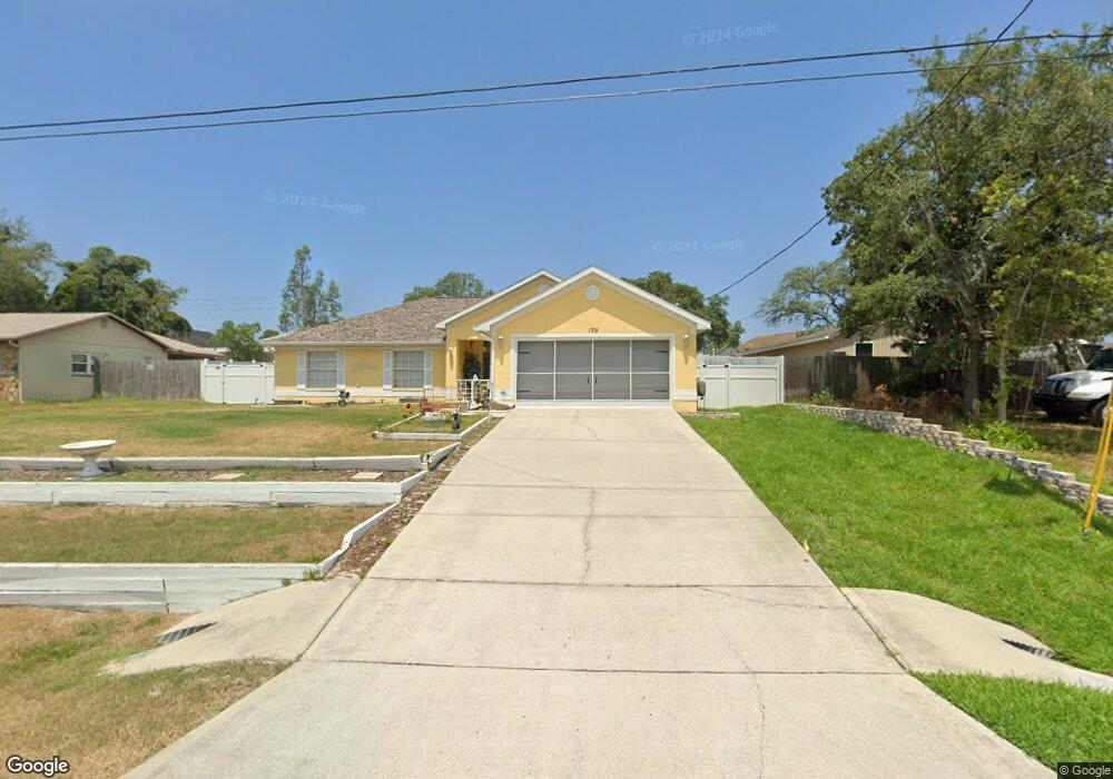
179 Bancroft Ave Spring Hill, FL 34606
Estimated Value: $297,366 - $324,000
4
Beds
2
Baths
1,755
Sq Ft
$178/Sq Ft
Est. Value
About This Home
This home is located at 179 Bancroft Ave, Spring Hill, FL 34606 and is currently estimated at $312,842, approximately $178 per square foot. 179 Bancroft Ave is a home located in Hernando County with nearby schools including Suncoast Elementary School, Fox Chapel Middle School, and Frank W. Springstead High School.
Ownership History
Date
Name
Owned For
Owner Type
Purchase Details
Closed on
Oct 27, 2016
Sold by
Ryczek Joshua S and Ryczek Michele
Bought by
Colasante Lisa
Current Estimated Value
Purchase Details
Closed on
Apr 23, 2007
Sold by
Adams Homes Of Northwest Florida Inc
Bought by
Ryczek Joshua S
Home Financials for this Owner
Home Financials are based on the most recent Mortgage that was taken out on this home.
Original Mortgage
$136,720
Interest Rate
6.1%
Mortgage Type
Purchase Money Mortgage
Purchase Details
Closed on
Apr 8, 2005
Sold by
Klein James T
Bought by
G & O Solutions Enterprise Inc
Create a Home Valuation Report for This Property
The Home Valuation Report is an in-depth analysis detailing your home's value as well as a comparison with similar homes in the area
Home Values in the Area
Average Home Value in this Area
Purchase History
| Date | Buyer | Sale Price | Title Company |
|---|---|---|---|
| Colasante Lisa | $150,000 | Southeast Title Suncoast Inc | |
| Ryczek Joshua S | $170,900 | Paramount Title Corporation | |
| G & O Solutions Enterprise Inc | $17,000 | Allied Title Insurance Inc |
Source: Public Records
Mortgage History
| Date | Status | Borrower | Loan Amount |
|---|---|---|---|
| Previous Owner | Ryczek Joshua S | $136,720 |
Source: Public Records
Tax History
| Year | Tax Paid | Tax Assessment Tax Assessment Total Assessment is a certain percentage of the fair market value that is determined by local assessors to be the total taxable value of land and additions on the property. | Land | Improvement |
|---|---|---|---|---|
| 2025 | $1,943 | $127,066 | -- | -- |
| 2024 | $1,844 | $123,485 | -- | -- |
| 2023 | $1,844 | $119,888 | $0 | $0 |
| 2022 | $1,752 | $116,396 | $0 | $0 |
| 2021 | $1,742 | $113,006 | $0 | $0 |
| 2020 | $1,623 | $111,446 | $0 | $0 |
| 2019 | $1,617 | $108,940 | $0 | $0 |
| 2018 | $1,033 | $106,909 | $0 | $0 |
| 2017 | $1,307 | $104,710 | $8,000 | $96,710 |
| 2016 | $899 | $79,577 | $0 | $0 |
| 2015 | $900 | $79,024 | $0 | $0 |
| 2014 | $880 | $78,397 | $0 | $0 |
Source: Public Records
Map
Nearby Homes
- 7181 Clearwater Dr
- 216 Cobblestone Dr
- 7350 Landmark Dr
- 7157 Landmark Dr
- 7264 Lindhurst St
- 126 Canby Cir
- 0 County Line Rd
- 307 Plumtree Ave
- 7253 Lamplighter St
- 7244 Tranquil Dr
- 18818 Skiff Dr
- 0 Clearwater Dr
- 7547 Landmark Dr
- 7605 Landmark Dr
- 7318 Tranquil Dr
- 18842 Seacraft Dr
- 351 Upland Ave
- 18923 Rolling Oak Dr
- 18736 Tortuga Dr
- 6533 Clearwater Dr
- 171 Bancroft Ave
- 147 Bancroft Ave
- 246 Cobblestone Dr
- 244 Cobblestone Dr
- 163 Bancroft Ave
- 199 Bancroft Ave
- 7208 Clearwater Dr
- 178 Bancroft Ave
- 186 Bancroft Ave
- 170 Bancroft Ave
- 240 Cobblestone Dr
- 155 Bancroft Ave
- 194 Bancroft Ave
- 236 Cobblestone Dr
- 7205 Clearwater Dr
- 7229 Davenport Ln
- 7237 Davenport Ln
- 202 Bancroft Ave
- 7211 Clearwater Dr
- 7221 Davenport Ln
Your Personal Tour Guide
Ask me questions while you tour the home.