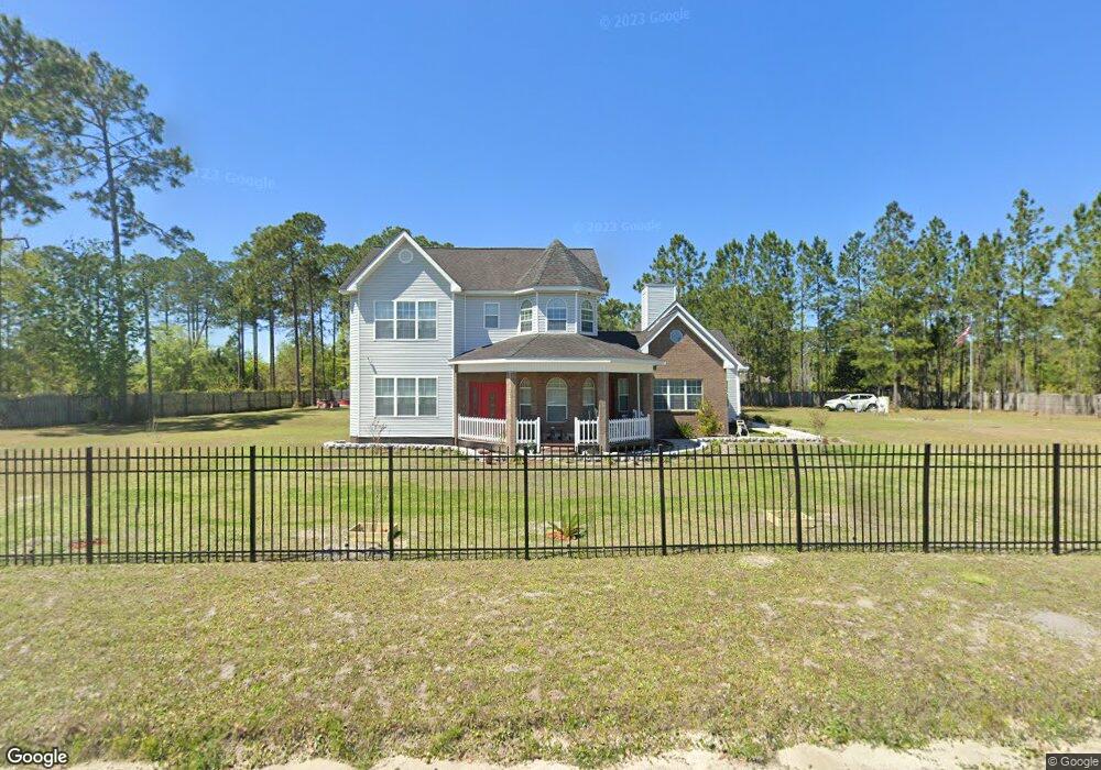
179 Prescott Rd Folkston, GA 31537
Estimated Value: $348,000 - $450,000
5
Beds
5
Baths
3,025
Sq Ft
$138/Sq Ft
Est. Value
About This Home
This home is located at 179 Prescott Rd, Folkston, GA 31537 and is currently estimated at $418,713, approximately $138 per square foot. 179 Prescott Rd is a home located in Charlton County with nearby schools including Charlton County High School and Charlton Christian Academy.
Ownership History
Date
Name
Owned For
Owner Type
Purchase Details
Closed on
Apr 28, 2017
Sold by
Harvey Cynthia R
Bought by
Harvey Kevin K
Current Estimated Value
Home Financials for this Owner
Home Financials are based on the most recent Mortgage that was taken out on this home.
Original Mortgage
$171,830
Outstanding Balance
$141,684
Interest Rate
4.14%
Mortgage Type
VA
Estimated Equity
$277,029
Purchase Details
Closed on
Apr 15, 1995
Bought by
Davis Wallace and Davis Ethel
Create a Home Valuation Report for This Property
The Home Valuation Report is an in-depth analysis detailing your home's value as well as a comparison with similar homes in the area
Home Values in the Area
Average Home Value in this Area
Purchase History
| Date | Buyer | Sale Price | Title Company |
|---|---|---|---|
| Harvey Kevin K | -- | -- | |
| Davis Wallace | $5,000 | -- |
Source: Public Records
Mortgage History
| Date | Status | Borrower | Loan Amount |
|---|---|---|---|
| Open | Harvey Kevin K | $171,830 |
Source: Public Records
Tax History
| Year | Tax Paid | Tax Assessment Tax Assessment Total Assessment is a certain percentage of the fair market value that is determined by local assessors to be the total taxable value of land and additions on the property. | Land | Improvement |
|---|---|---|---|---|
| 2025 | $4,702 | $182,108 | $6,760 | $175,348 |
| 2024 | $4,944 | $182,508 | $6,080 | $176,428 |
| 2023 | $4,464 | $155,828 | $6,080 | $149,748 |
| 2022 | $3,682 | $128,188 | $9,000 | $119,188 |
| 2021 | $2,817 | $78,152 | $3,120 | $75,032 |
| 2020 | $2,785 | $78,152 | $3,120 | $75,032 |
| 2019 | $2,818 | $78,152 | $3,120 | $75,032 |
| 2018 | $2,853 | $78,152 | $3,120 | $75,032 |
| 2017 | $2,820 | $77,352 | $3,120 | $74,232 |
| 2016 | $2,814 | $77,352 | $3,120 | $74,232 |
| 2015 | -- | $77,352 | $3,120 | $74,232 |
| 2014 | -- | $77,352 | $3,120 | $74,232 |
| 2013 | -- | $77,352 | $3,120 | $74,232 |
Source: Public Records
Map
Nearby Homes
- 270 Noah Everett Dr
- 212 Wiregrass Rd
- 120 John H Carter III Ln
- 3204 Route 1
- 0 Passieu Cir Unit 20171701
- 18558 U S 301
- 1834 Highway 252
- 1630 Highway 252
- 0 (LOT 4) Dogwood Ln Unit LOT 4
- 0 (LOT 3) Dogwood Ln Unit LOT 3
- 0(LOT 2) Dogwood Ln Unit LOT 2
- 0 (LOT 5) Dogwood Ln Unit LOT 5
- 0 (LOT 6) Dogwood Ln
- 125 Kingsland Dr
- 125 Settlers Way
- 96 Gabby St
- 116 Pinckney Dr
- 242 Pinehurst Dr
- 621 Pinewood St
- 45 Azalea Ave
- 0 Prescott Rd
- 263 Prescott Rd
- 89 Prescott Rd
- 67 Prescott Rd
- 43 Prescott Rd
- 205 Noah Everett Dr
- 44 N Indian Trail
- 44 N Indian Trail
- 816 Indian Trail
- 870 Indian Trail
- 202 Albert Smith St
- 883 Indian Trail
- 45 Indian Trail
- 220 Albert Smith St
- 140 Al Smith St
- 232 Wiregrass Rd
- 132 Al Smith St
- 37 Albert Smith St
- 684 Indian Trail
- 114 Albert Smith St
Your Personal Tour Guide
Ask me questions while you tour the home.