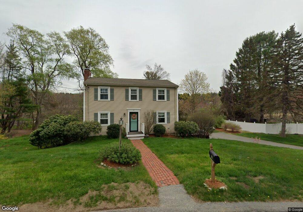
Estimated Value: $645,129 - $762,000
4
Beds
2
Baths
1,472
Sq Ft
$477/Sq Ft
Est. Value
About This Home
This home is located at 18 Cherokee Rd, Acton, MA 01720 and is currently estimated at $702,032, approximately $476 per square foot. 18 Cherokee Rd is a home located in Middlesex County with nearby schools including Acton-Boxborough Regional High School.
Ownership History
Date
Name
Owned For
Owner Type
Purchase Details
Closed on
Jul 20, 2006
Sold by
Bowers Carolyn A
Bought by
Rutyna Julianne Shield
Current Estimated Value
Home Financials for this Owner
Home Financials are based on the most recent Mortgage that was taken out on this home.
Original Mortgage
$275,000
Outstanding Balance
$163,441
Interest Rate
6.67%
Mortgage Type
Purchase Money Mortgage
Estimated Equity
$538,591
Create a Home Valuation Report for This Property
The Home Valuation Report is an in-depth analysis detailing your home's value as well as a comparison with similar homes in the area
Home Values in the Area
Average Home Value in this Area
Purchase History
| Date | Buyer | Sale Price | Title Company |
|---|---|---|---|
| Rutyna Julianne Shield | $425,000 | -- |
Source: Public Records
Mortgage History
| Date | Status | Borrower | Loan Amount |
|---|---|---|---|
| Open | Rutyna Julianne Shield | $275,000 |
Source: Public Records
Tax History
| Year | Tax Paid | Tax Assessment Tax Assessment Total Assessment is a certain percentage of the fair market value that is determined by local assessors to be the total taxable value of land and additions on the property. | Land | Improvement |
|---|---|---|---|---|
| 2025 | $9,896 | $577,000 | $313,700 | $263,300 |
| 2024 | $9,340 | $560,300 | $313,700 | $246,600 |
| 2023 | $9,063 | $516,100 | $285,000 | $231,100 |
| 2022 | $8,612 | $442,800 | $247,900 | $194,900 |
| 2021 | $8,501 | $420,200 | $229,500 | $190,700 |
| 2020 | $8,033 | $417,500 | $229,500 | $188,000 |
| 2019 | $7,587 | $391,700 | $229,500 | $162,200 |
| 2018 | $7,492 | $386,600 | $229,500 | $157,100 |
| 2017 | $7,321 | $384,100 | $229,500 | $154,600 |
| 2016 | $7,327 | $381,000 | $229,500 | $151,500 |
| 2015 | $7,052 | $370,200 | $229,500 | $140,700 |
| 2014 | $6,936 | $356,600 | $229,500 | $127,100 |
Source: Public Records
Map
Nearby Homes
- 13 Mohegan Rd
- 27 Captain Brown's Ln
- 15 Long Ridge Rd
- 10 Long Ridge Rd
- 159 Prospect St Unit 4
- 53 Cortland Ln Unit 53
- 33 Meadowbrook Rd
- 27 Tuttle Dr
- 491 Main St
- 389 Arlington St
- 524 Main St
- 92 Willow St Unit 1
- 94 Willow St Unit 2
- 182 Main St Unit 4
- 146 Tahattawan Rd
- 15 Martin St
- 21 Nashoba Rd
- 35 Greenside Ln Unit 35
- 557 Acorn Park Dr
- 10 Bulkeley Rd
Your Personal Tour Guide
Ask me questions while you tour the home.