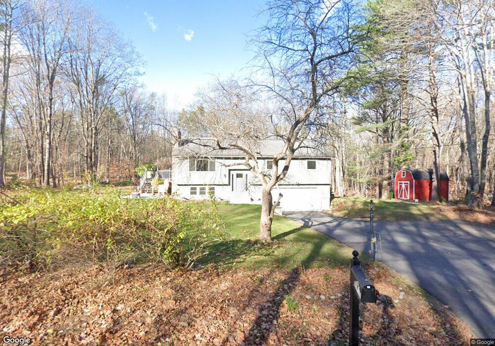
18 Stuart Shores Rd Standish, ME 04084
North Gorham NeighborhoodEstimated Value: $456,831 - $569,000
3
Beds
2
Baths
2,130
Sq Ft
$234/Sq Ft
Est. Value
About This Home
This home is located at 18 Stuart Shores Rd, Standish, ME 04084 and is currently estimated at $497,958, approximately $233 per square foot. 18 Stuart Shores Rd is a home located in Cumberland County with nearby schools including Bonny Eagle High School and Windham Christian Academy.
Ownership History
Date
Name
Owned For
Owner Type
Purchase Details
Closed on
Oct 1, 2010
Sold by
Cyr Ruthellen
Bought by
Conley Martha and Conley Steve J
Current Estimated Value
Home Financials for this Owner
Home Financials are based on the most recent Mortgage that was taken out on this home.
Original Mortgage
$199,402
Outstanding Balance
$128,546
Interest Rate
4.44%
Mortgage Type
Purchase Money Mortgage
Estimated Equity
$369,412
Create a Home Valuation Report for This Property
The Home Valuation Report is an in-depth analysis detailing your home's value as well as a comparison with similar homes in the area
Home Values in the Area
Average Home Value in this Area
Purchase History
We collect this data history from publicly available records. To have your information removed, we recommend requesting removal directly through your county’s website.
| Date | Buyer | Sale Price | Title Company |
|---|---|---|---|
| Conley Martha | $209,900 | -- | |
| Conley Martha | $209,900 | -- |
Source: Public Records
Mortgage History
We collect this data history from publicly available records. To have your information removed, we recommend requesting removal directly through your county’s website.
| Date | Status | Borrower | Loan Amount |
|---|---|---|---|
| Open | Conley Martha | $199,402 | |
| Closed | Conley Martha | $199,402 | |
| Previous Owner | Conley Martha | $25,000 |
Source: Public Records
Tax History
| Year | Tax Paid | Tax Assessment Tax Assessment Total Assessment is a certain percentage of the fair market value that is determined by local assessors to be the total taxable value of land and additions on the property. | Land | Improvement |
|---|---|---|---|---|
| 2025 | $4,111 | $331,500 | $86,200 | $245,300 |
| 2024 | $3,849 | $305,500 | $79,700 | $225,800 |
| 2023 | $3,521 | $254,200 | $64,200 | $190,000 |
| 2022 | $3,347 | $231,600 | $57,200 | $174,400 |
| 2021 | $2,829 | $213,600 | $52,000 | $161,600 |
| 2019 | $2,849 | $199,200 | $49,400 | $149,800 |
| 2018 | $2,353 | $194,000 | $44,200 | $149,800 |
| 2017 | $6,977 | $194,000 | $44,200 | $149,800 |
| 2016 | $2,487 | $194,000 | $44,200 | $149,800 |
| 2015 | $2,481 | $194,000 | $44,200 | $149,800 |
| 2013 | -- | $194,000 | $44,200 | $149,800 |
Source: Public Records
Map
Nearby Homes
- 474 Whites Bridge Rd
- 72 Sand Beach Rd
- 103 Basin Rd
- 158 Hearthside Rd
- 86 Basin Rd
- 35 Woldbrook Dr
- 34 Trails End Rd
- 20 Freeman Ct
- 8 Lamb St
- 96 Mineral Spring Rd
- 10 Abby Rd
- 12 Shore Rd
- 114 Wild Acres Rd
- 55 Page Rd
- 0 Turning Leaf Dr Unit 1640377
- 9 Settlers Ct
- 7 Papoose Island Rd
- 3 Glidden Rd
- 1042 Roosevelt Trail
- 71 Quarry Cove Rd
- 8 Stuart Shores Rd
- 15 Stuart Shores Rd
- 0 Lt 19 Stuart Shores Rd
- 19 Stuart Shores
- 6 Ridge View Dr
- 5 Ridge View Dr
- 3 Strout Brook
- 16 Ridge View Dr
- 19 Leisure Point Rd
- 11 Ridge View Dr
- 443 Whites Bridge Rd
- 31 Stuart Shores Rd
- 450 Whites Bridge Rd
- 26 Ridge View Dr
- 415 Whites Bridge Rd
- 19 Ridge View Dr
- 4 Highland Rd
- 430 Whites Bridge Rd
- 3 Basin Harbor Dr
- 18 Highland Rd
Your Personal Tour Guide
Ask me questions while you tour the home.