1813 Smoketree Ln Alabaster, AL 35007
Estimated Value: $265,000 - $303,135
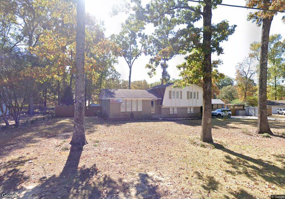
About This Home
This home is located at 1813 Smoketree Ln, Alabaster, AL 35007 and is currently estimated at $285,784, approximately $164 per square foot. 1813 Smoketree Ln is a home located in Shelby County with nearby schools including Thompson Intermediate School, Thompson Middle School, and Thompson High School.
Ownership History
We collect this data history from publicly available records. To have your information removed, we recommend requesting removal directly through your county’s website.
Purchase Details
Home Financials for this Owner
Home Financials are based on the most recent Mortgage that was taken out on this home.Home Values in the Area
Average Home Value in this Area
Purchase History
We collect this data history from publicly available records. To have your information removed, we recommend requesting removal directly through your county’s website.
| Date | Buyer | Sale Price | Title Company |
|---|---|---|---|
| $184,000 | None Available |
Mortgage History
We collect this data history from publicly available records. To have your information removed, we recommend requesting removal directly through your county’s website.
| Date | Status | Borrower | Loan Amount |
|---|---|---|---|
| Open | $178,480 |
Tax History
We collect this data history from publicly available records. To have your information removed, we recommend requesting removal directly through your county’s website.
| Year | Tax Paid | Tax Assessment Tax Assessment Total Assessment is a certain percentage of the fair market value that is determined by local assessors to be the total taxable value of land and additions on the property. | Land | Improvement |
|---|---|---|---|---|
| 2025 | $1,495 | $27,680 | $0 | $0 |
| 2024 | $1,410 | $26,120 | $0 | $0 |
| 2023 | $1,286 | $24,580 | $0 | $0 |
| 2022 | $1,197 | $22,920 | $0 | $0 |
| 2021 | $1,107 | $21,260 | $0 | $0 |
| 2020 | $971 | $18,740 | $0 | $0 |
| 2019 | $827 | $16,080 | $0 | $0 |
| 2017 | $728 | $14,240 | $0 | $0 |
| 2015 | $686 | $13,460 | $0 | $0 |
| 2014 | $669 | $13,140 | $0 | $0 |
Map
- 1349 Old Boston Rd
- 220 Cedar Meadow
- 124 Kingsley Rd
- 630 Navajo Trail
- 303 Meadow Cir
- 542 Navajo Trail
- 263 Norwick Forest Dr
- 120 Mayfair Park
- 1123 5th Ave NW
- 306 Mayfair Cir
- 231 Norwick Forest Dr
- 105 Paddington Station
- 504 Ramsgate Dr
- 1209 Sequoia Trail
- 335 10th St NW
- 501 Ramsgate Dr
- 937 5th Ave NW
- 1117 Independence Dr
- 236 Queens Gate
- 1046 Independence Ct
- 1813 Smoke Tree Ln
- 1809 Smoketree Ln
- 1812 Apache Way
- 1809 Smoke Tree Ln
- 1817 Smoketree Ln
- 1816 Apache Way
- 1808 Smoketree Ln
- 1808 Apache Way
- 1812 Smoketree Ln
- 1805 Smoketree Ln
- 1804 Smoketree Ln
- 1818 Apache Way
- 1804 Apache Way
- 1813 Apache Way
- 1809 Arrow Dr
- 1817 Apache Way
- 1813 Arrow Dr
- 1805 Arrow Dr
- 1821 Apache Way
- 1817 Arrow Dr
Ask me questions while you tour the home.