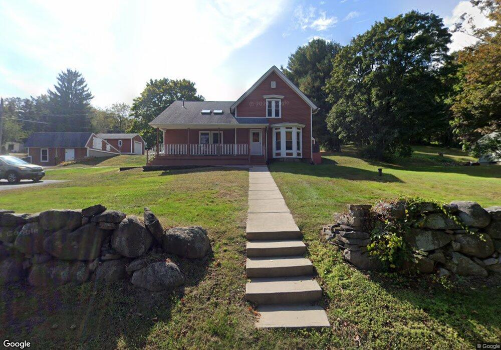
182 Maple Ave Uncasville, CT 06382
Oxoboxo River NeighborhoodEstimated Value: $325,891 - $389,000
3
Beds
2
Baths
1,692
Sq Ft
$214/Sq Ft
Est. Value
About This Home
This home is located at 182 Maple Ave, Uncasville, CT 06382 and is currently estimated at $361,723, approximately $213 per square foot. 182 Maple Ave is a home located in New London County with nearby schools including Leonard J. Tyl Middle School, Montville High School, and Bradley School-New London Regional.
Ownership History
Date
Name
Owned For
Owner Type
Purchase Details
Closed on
May 10, 2010
Sold by
Adams Douglas G
Bought by
Toello Nicholas P and Adams Douglas G
Current Estimated Value
Create a Home Valuation Report for This Property
The Home Valuation Report is an in-depth analysis detailing your home's value as well as a comparison with similar homes in the area
Home Values in the Area
Average Home Value in this Area
Purchase History
| Date | Buyer | Sale Price | Title Company |
|---|---|---|---|
| Toello Nicholas P | -- | -- | |
| Toello Nicholas P | -- | -- |
Source: Public Records
Mortgage History
| Date | Status | Borrower | Loan Amount |
|---|---|---|---|
| Previous Owner | Toello Nicholas P | $50,000 |
Source: Public Records
Tax History
| Year | Tax Paid | Tax Assessment Tax Assessment Total Assessment is a certain percentage of the fair market value that is determined by local assessors to be the total taxable value of land and additions on the property. | Land | Improvement |
|---|---|---|---|---|
| 2025 | $4,410 | $152,740 | $31,640 | $121,100 |
| 2024 | $4,242 | $152,740 | $31,640 | $121,100 |
| 2023 | $4,242 | $152,740 | $31,640 | $121,100 |
| 2022 | $4,080 | $152,740 | $31,640 | $121,100 |
| 2021 | $3,926 | $123,660 | $31,840 | $91,820 |
| 2020 | $4,004 | $123,660 | $31,840 | $91,820 |
| 2019 | $4,020 | $123,660 | $31,840 | $91,820 |
| 2018 | $3,924 | $123,660 | $31,840 | $91,820 |
| 2017 | $3,920 | $123,660 | $31,840 | $91,820 |
| 2016 | $3,760 | $122,830 | $39,750 | $83,080 |
| 2015 | $3,760 | $122,830 | $39,750 | $83,080 |
| 2014 | $3,608 | $122,830 | $39,750 | $83,080 |
Source: Public Records
Map
Nearby Homes
- 76 Gay Hill Rd
- 31 Bridge St
- 0 Monahan Dr
- 4 Pequot Rd
- 25 Heather Brook Rd
- 355 Route 163
- 320 Maple Ave
- 19 Moxley Rd
- 66 Rainbow Dr
- 5 Blumenthal Dr
- 11 Blumenthal Dr
- 571 Old Colchester Rd
- 2 Fawns Meadow Rd
- 4 Brewer St
- 95 Kitemaug Rd
- 16 Greystone Dr
- 17 Comstock Ave
- 168 Kitemaug Rd
- 165 Massapeag Rd
- 79 Cottonwood Ln
- 16 Roselund Hill Rd
- 2 Roselund Hill Rd
- 186 Maple Ave
- 29 Roselund Hill Rd
- 172 Maple Ave
- 191 Maple Ave
- 187 Maple Ave
- 177 Maple Ave
- 191 Maple Ave
- 14 Roselund Hill Rd
- 195 Maple Ave
- 37 Roselund Hill Rd
- 173 Maple Ave
- 190 Maple Ave
- 28 Roselund Hill Rd
- 39 Roselund Hill Rd
- 192 Maple Ave
- 199 Maple Ave
- 168 Maple Ave
- 181 Maple Ave
Your Personal Tour Guide
Ask me questions while you tour the home.