J
Landlord's Agent in 2026
Jaclyn Manchester
BHHS New England Properties
(401) 580-5259
4 in this area
24 Total Sales


Estimated Value: $461,748 - $514,000
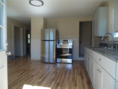
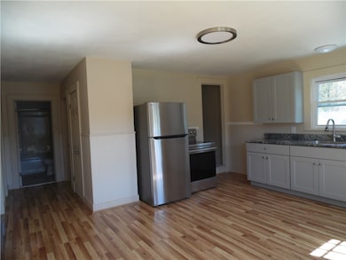
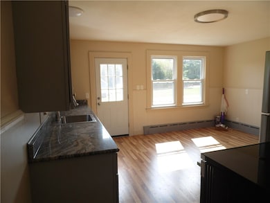
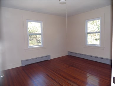
This updated Cape-style home, located at 182 Westerly Bradford Road in Westerly, RI's Chapman Pond neighborhood, is available for yearly rent. The property features three bedrooms and one full bathroom, with one bedroom and the full bathroom conveniently situated on the main floor.
The residence, built in 1900, offers 1,349 square feet of living space and is set on over 12 acres of land. The interior has been updated and includes flooring of ceramic tile, hardwood, and laminate. The home is unfurnished and includes an oven/range and refrigerator. Heating is provided by oil, forced water.
No pets. Washer & Dryer hookup available in basement. Lawn and driveway care are included in lease.
Last Agent to Rent the Property
BHHS New England Properties License #RES.0041375 Listed on: 09/26/2025

We collect this data history from publicly available records. To have your information removed, we recommend requesting removal directly through your county’s website.
| Date | Buyer | Sale Price | Title Company |
|---|---|---|---|
| Joseph J Algiere 1995 | -- | -- | |
| Joseph J Algiere 1995 | -- | -- | |
| Algiere Joseph J | $75,000 | -- |
We collect this data history from publicly available records. To have your information removed, we recommend requesting removal directly through your county’s website.
| Date | Status | Borrower | Loan Amount |
|---|---|---|---|
| Previous Owner | Algiere Joseph J | $100,000 |
| Date | Event | Price | List to Sale | Price per Sq Ft |
|---|---|---|---|---|
| 04/29/2026 04/29/26 | Rented | $2,800 | 0.0% | -- |
| 10/11/2025 10/11/25 | Price Changed | $2,800 | -6.7% | $2 / Sq Ft |
| 09/26/2025 09/26/25 | For Rent | $3,000 | -- | -- |
| Year | Tax Paid | Tax Assessment Tax Assessment Total Assessment is a certain percentage of the fair market value that is determined by local assessors to be the total taxable value of land and additions on the property. | Land | Improvement |
|---|---|---|---|---|
| 2025 | $3,305 | $464,800 | $291,600 | $173,200 |
| 2024 | $3,330 | $339,400 | $235,500 | $103,900 |
| 2023 | $3,265 | $339,400 | $235,500 | $103,900 |
| 2022 | $3,245 | $339,400 | $235,500 | $103,900 |
| 2021 | $3,435 | $298,200 | $217,000 | $81,200 |
| 2020 | $3,373 | $298,200 | $217,000 | $81,200 |
| 2019 | $3,340 | $298,200 | $217,000 | $81,200 |
| 2018 | $3,328 | $280,100 | $217,000 | $63,100 |
| 2017 | $3,246 | $280,100 | $217,000 | $63,100 |
| 2016 | $3,272 | $280,100 | $217,000 | $63,100 |
| 2015 | $2,967 | $274,200 | $208,100 | $66,100 |
| 2014 | $2,917 | $274,200 | $208,100 | $66,100 |
J
Landlord's Agent in 2026
Jaclyn Manchester
BHHS New England Properties
(401) 580-5259
4 in this area
24 Total Sales
Tenant's Agent in 2026
Jessica Gardner
Keller Williams Coastal
(401) 932-4326
8 in this area
57 Total Sales
Source: State-Wide MLS
MLS Number: 1395757
APN: WEST-000050-000011
Disclaimer: Certain information contained herein is derived from information provided by parties other than Homes.com. All information provided is deemed reliable, but is not guaranteed to be accurate and should be independently verified.
![]() IDX information is provided exclusively for personal, non-commercial use, and may not be used for any purpose other than to identify prospective properties consumers may be interested in purchasing. Information is deemed reliable but not guaranteed.
IDX information is provided exclusively for personal, non-commercial use, and may not be used for any purpose other than to identify prospective properties consumers may be interested in purchasing. Information is deemed reliable but not guaranteed.
Copyright © 2026 State-Wide MLS, Inc. All rights reserved.
Ask me questions while you tour the home.