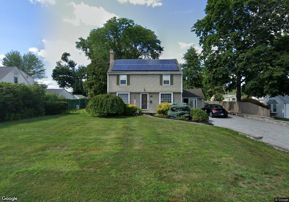
184 Dowd St Newington, CT 06111
Estimated Value: $333,115 - $367,000
3
Beds
3
Baths
1,189
Sq Ft
$298/Sq Ft
Est. Value
About This Home
This home is located at 184 Dowd St, Newington, CT 06111 and is currently estimated at $354,029, approximately $297 per square foot. 184 Dowd St is a home located in Hartford County with nearby schools including Anna Reynolds School, Martin Kellogg Middle School, and Newington High School.
Ownership History
Date
Name
Owned For
Owner Type
Purchase Details
Closed on
Aug 31, 2001
Sold by
Esoian Leslie A
Bought by
Lennon Ann L
Current Estimated Value
Purchase Details
Closed on
Aug 14, 1998
Sold by
Taravella Jerome J
Bought by
Hout Leslie A
Create a Home Valuation Report for This Property
The Home Valuation Report is an in-depth analysis detailing your home's value as well as a comparison with similar homes in the area
Home Values in the Area
Average Home Value in this Area
Purchase History
| Date | Buyer | Sale Price | Title Company |
|---|---|---|---|
| Lennon Ann L | $174,000 | -- | |
| Hout Leslie A | $116,000 | -- |
Source: Public Records
Mortgage History
| Date | Status | Borrower | Loan Amount |
|---|---|---|---|
| Open | Hout Leslie A | $192,000 | |
| Closed | Hout Leslie A | $21,000 | |
| Closed | Hout Leslie A | $174,000 | |
| Closed | Hout Leslie A | $133,300 |
Source: Public Records
Tax History
| Year | Tax Paid | Tax Assessment Tax Assessment Total Assessment is a certain percentage of the fair market value that is determined by local assessors to be the total taxable value of land and additions on the property. | Land | Improvement |
|---|---|---|---|---|
| 2025 | $4,950 | $123,820 | $56,010 | $67,810 |
| 2024 | $4,912 | $123,820 | $56,010 | $67,810 |
| 2023 | $4,750 | $123,820 | $56,010 | $67,810 |
| 2022 | $4,766 | $123,820 | $56,010 | $67,810 |
| 2021 | $4,805 | $123,820 | $56,010 | $67,810 |
| 2020 | $4,696 | $119,560 | $52,510 | $67,050 |
| 2019 | $4,717 | $119,560 | $52,510 | $67,050 |
| 2018 | $4,603 | $119,560 | $52,510 | $67,050 |
| 2017 | $4,375 | $119,560 | $52,510 | $67,050 |
| 2016 | $4,274 | $119,560 | $52,510 | $67,050 |
| 2014 | $4,690 | $134,900 | $52,900 | $82,000 |
Source: Public Records
Map
Nearby Homes
- 42 Sunset Rd
- 681 Main St
- 140 Camp Ave
- 14 Coolidge Ave
- 55 Old Farm Dr
- 6 Old Farm Dr
- 9 Old Farm Dr
- 7 Old Farm Dr
- 84 Connecticut Ave
- 5 Old Farm Dr
- 1 Old Farm Dr
- 24 Millbrook Ct Unit 24 Millbrook Ct Newi
- 88 Hawley St
- 149 Moylan Ct
- 20 Browning Ave
- 20 Brook St
- 15 Cricket Ln
- 134 Williamstown Ct Unit 134
- 138 Williamstown Ct Unit 138
- 203 Brentwood Rd
Your Personal Tour Guide
Ask me questions while you tour the home.