1840 Mcphail St Flint, MI 48503
South Parks NeighborhoodEstimated payment $57/month
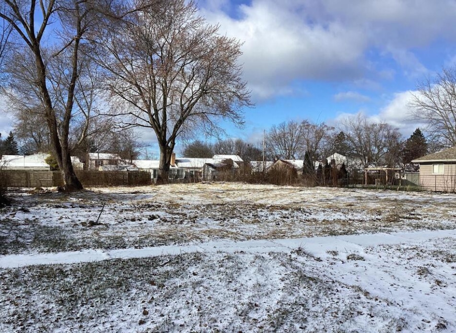
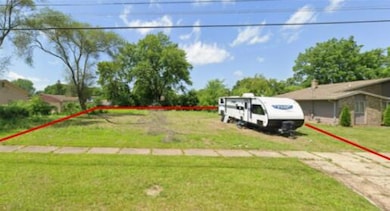
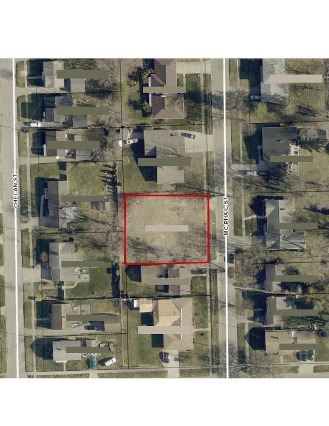
About This Lot
Excellent investment opportunity in the heart of Flint! This vacant lot is zoned TN-2 (Traditional Neighborhood 2), which allows for multi-family, duplex, townhouse, or mixed-use residential construction. The TN-2 zoning encourages walkable, neighborhood-scale development and supports a variety of residential and limited commercial uses.
Located near downtown Flint, Mott Community College, and the University of Michigan-Flint, this property offers convenient access to schools, shopping, dining, and major transportation routes. Quit Claim Deed.
Property Details
Property Type
- Land
Lot Details
- 12,632 Sq Ft Lot
- Lot Dimensions are 100 x 175
- Property is zoned TN-2, TN-2
Map
Home Values in the Area
Average Home Value in this Area
Tax History
| Year | Tax Paid | Tax Assessment Tax Assessment Total Assessment is a certain percentage of the fair market value that is determined by local assessors to be the total taxable value of land and additions on the property. | Land | Improvement |
|---|---|---|---|---|
| 2025 | $437 | $12,000 | $0 | $0 |
| 2024 | $421 | $24,000 | $0 | $0 |
| 2023 | $382 | $8,700 | $0 | $0 |
| 2022 | $0 | $8,100 | $0 | $0 |
| 2021 | $383 | $7,600 | $0 | $0 |
| 2020 | $367 | $2,500 | $0 | $0 |
| 2019 | $1,991 | $45,700 | $0 | $0 |
| 2018 | $2,116 | $36,700 | $0 | $0 |
| 2017 | $2,118 | $0 | $0 | $0 |
| 2016 | $2,101 | $0 | $0 | $0 |
| 2015 | -- | $0 | $0 | $0 |
| 2014 | -- | $0 | $0 | $0 |
| 2012 | -- | $48,100 | $0 | $0 |
Property History
| Date | Event | Price | List to Sale | Price per Sq Ft |
|---|---|---|---|---|
| 11/11/2025 11/11/25 | For Sale | $9,000 | -- | -- |
Purchase History
| Date | Type | Sale Price | Title Company |
|---|---|---|---|
| Quit Claim Deed | $2,000 | None Listed On Document | |
| Deed | $40,000 | None Available | |
| Warranty Deed | -- | None Available | |
| Sheriffs Deed | $112,259 | None Available | |
| Warranty Deed | $100,000 | Sargents Title Company |
Source: MichRIC
MLS Number: 25057635
APN: 41-17-428-023
Disclaimer: Certain information contained herein is derived from information provided by parties other than Homes.com. All information provided is deemed reliable, but is not guaranteed to be accurate and should be independently verified.
![]() Information is deemed reliable but not guaranteed.
Information is deemed reliable but not guaranteed.
Copyright 2026 MichRIC, LLC. All rights reserved.
- 1826 Whittlesey St
- 9211 Owen St
- 1930 Owen St
- 1851 Seymour Ave
- 2029 Winans Ave
- 1510 S Franklin Ave
- 1925 Gilmartin St
- 1856 Tebo St
- 1828 Tebo St
- 3373 Kent St
- 1114 W Vernon Dr
- 2010 Crocker Ave
- 1210 Blanchard Ave
- 2221 Howard Ave
- 3511 Kent St
- 2013 E Court St
- 2224 Crocker Ave
- 2050 Ferris Ave
- 2910 Shawnee Ave
- 1701 Park St
- 3817 Lippincott Apt 13 Lippincott Apt 13
- 3817 Lippincott Apt 17 Lippincott Apt 17 Unit 17
- 612 E 3rd St Unit Apartment#3
- 310 E 3rd St
- 1414 N Lynch #2 St
- 1414 N Lynch #1 St
- 411 E 2nd St
- 2621 Churchill Ave
- 318 W 2nd St
- 3702 Ivanhoe Ave
- 607 E 2nd Ave
- 2486 Green Pine Dr
- 901 F J McCree Dr
- 421 W Water St
- 1001 N Saginaw St Unit 8
- 925 Leland St
- 3202 Western Rd
- 1220 Alvord Ave
- 2188 E Parkwood Ave
- 1436 Berrywood Ln

Ask me questions while you tour the home.