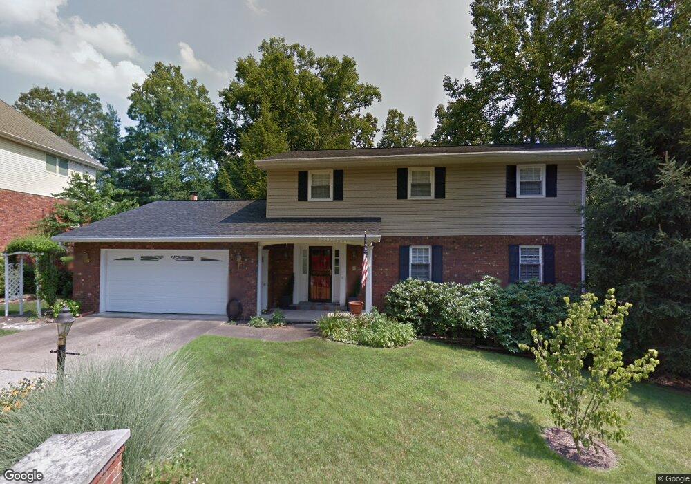
1847 Devondale Cir Charleston, WV 25314
South Hills NeighborhoodEstimated Value: $326,000 - $404,000
4
Beds
4
Baths
2,380
Sq Ft
$152/Sq Ft
Est. Value
About This Home
This home is located at 1847 Devondale Cir, Charleston, WV 25314 and is currently estimated at $360,966, approximately $151 per square foot. 1847 Devondale Cir is a home located in Kanawha County with nearby schools including Overbrook Elementary School, John Adams Middle School, and George Washington High School.
Ownership History
Date
Name
Owned For
Owner Type
Purchase Details
Closed on
Jan 30, 2001
Sold by
Balevic Edward
Bought by
Eckerson Bruce
Current Estimated Value
Purchase Details
Closed on
Dec 14, 1998
Sold by
Rayment Donald
Bought by
Balenic Edward
Home Financials for this Owner
Home Financials are based on the most recent Mortgage that was taken out on this home.
Original Mortgage
$140,000
Interest Rate
6.8%
Mortgage Type
Purchase Money Mortgage
Create a Home Valuation Report for This Property
The Home Valuation Report is an in-depth analysis detailing your home's value as well as a comparison with similar homes in the area
Home Values in the Area
Average Home Value in this Area
Purchase History
| Date | Buyer | Sale Price | Title Company |
|---|---|---|---|
| Eckerson Bruce | $255,000 | -- | |
| Balenic Edward | $229,500 | -- |
Source: Public Records
Mortgage History
| Date | Status | Borrower | Loan Amount |
|---|---|---|---|
| Previous Owner | Balenic Edward | $140,000 |
Source: Public Records
Tax History
| Year | Tax Paid | Tax Assessment Tax Assessment Total Assessment is a certain percentage of the fair market value that is determined by local assessors to be the total taxable value of land and additions on the property. | Land | Improvement |
|---|---|---|---|---|
| 2025 | $2,133 | $152,580 | $34,140 | $118,440 |
| 2024 | $2,133 | $145,260 | $34,140 | $111,120 |
| 2023 | $1,924 | $139,560 | $34,140 | $105,420 |
| 2022 | $1,947 | $141,000 | $34,140 | $106,860 |
| 2021 | $1,801 | $132,360 | $34,140 | $98,220 |
| 2020 | $1,805 | $133,620 | $34,140 | $99,480 |
| 2019 | $1,794 | $133,620 | $34,140 | $99,480 |
| 2018 | $1,617 | $133,260 | $34,140 | $99,120 |
| 2017 | $1,607 | $133,260 | $34,140 | $99,120 |
| 2016 | $1,615 | $134,520 | $34,140 | $100,380 |
| 2015 | $1,602 | $134,520 | $34,140 | $100,380 |
| 2014 | $1,570 | $134,280 | $34,140 | $100,140 |
Source: Public Records
Map
Nearby Homes
- 1915 Rolling Hills Rd
- 109 Cyrus Point
- 1817 Huber Rd
- 1986 Parkwood Rd
- 1570 Smith Rd
- 106 Mullins Rd
- 1130 Lyndale Dr
- 16 Carriage Rd
- 263 Oakwood Rd
- 1501 Knob Rd
- 0 Lyndale Dr
- 12 Briar Hill Rd
- 1218 Lyndale Dr
- 2013 Huber Rd
- 1233 Lyndale Dr
- 234 Oakwood Rd
- 2307 Fairfax Rd
- 862 Alta Rd
- 105 Belfast Rd Unit 1&2
- 1538 Clark Rd
- 1845 Devondale Cir
- 1849 Devondale Cir
- 1859 Rolling Hills Rd
- 1857 Rolling Hills Rd
- 1826 Devondale Cir
- 1843 Devondale Cir
- 1853 Rolling Hills Rd
- 1818 Devondale Cir
- 1851 Devondale Cir
- 1808 Shadybrook Rd
- 1812 Shadybrook Rd
- 18 Birch Tree Ln
- 20 Birch Tree Ln
- 26 Birch Tree Ln
- 30 Birch Tree Ln
- 1841 Devondale Cir
- 1816 Shadybrook Rd
- 1817 Devondale Cir
- 1822 Devondale Cir
- 1816 Rolling Hills Rd
Your Personal Tour Guide
Ask me questions while you tour the home.