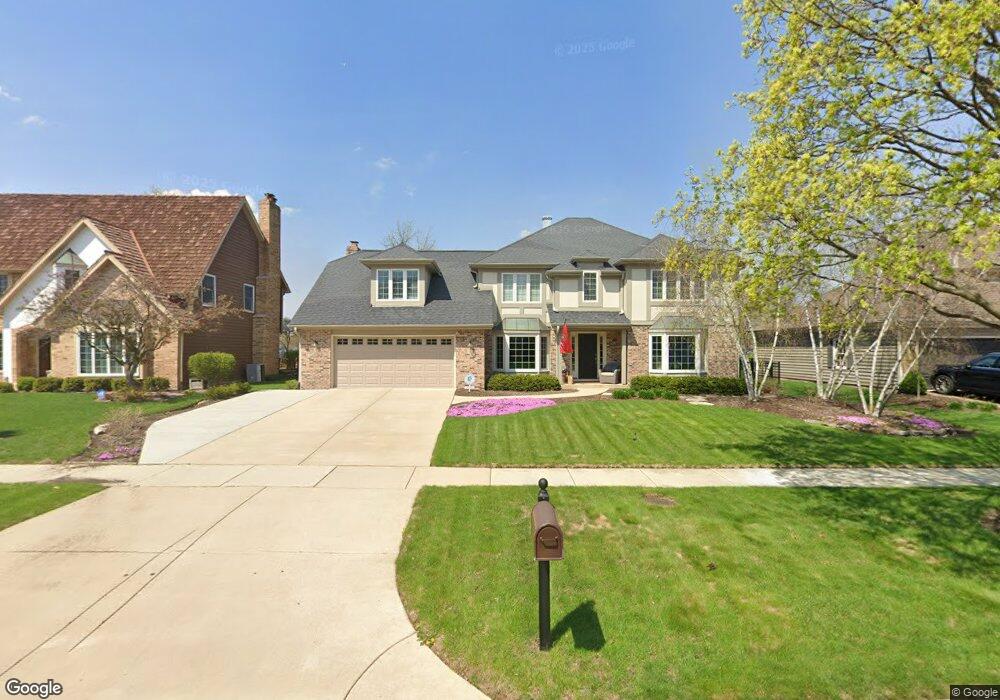
185 Danada Dr Wheaton, IL 60189
North Danada NeighborhoodEstimated Value: $725,971 - $892,000
4
Beds
3
Baths
3,109
Sq Ft
$270/Sq Ft
Est. Value
About This Home
This home is located at 185 Danada Dr, Wheaton, IL 60189 and is currently estimated at $839,993, approximately $270 per square foot. 185 Danada Dr is a home located in DuPage County with nearby schools including Madison Elementary School, Edison Middle School, and Wheaton Warrenville South High School.
Ownership History
Date
Name
Owned For
Owner Type
Purchase Details
Closed on
Jan 6, 2022
Sold by
Toppen Stephanie A
Bought by
Toppen Stephanie A and Stephanie A Toppen Trust
Current Estimated Value
Purchase Details
Closed on
Aug 19, 2003
Sold by
Moran John J and Moran Kathleen A
Bought by
Toppen Thomas A and Toppen Stephanie A
Home Financials for this Owner
Home Financials are based on the most recent Mortgage that was taken out on this home.
Original Mortgage
$390,000
Interest Rate
5.62%
Mortgage Type
Purchase Money Mortgage
Create a Home Valuation Report for This Property
The Home Valuation Report is an in-depth analysis detailing your home's value as well as a comparison with similar homes in the area
Home Values in the Area
Average Home Value in this Area
Purchase History
| Date | Buyer | Sale Price | Title Company |
|---|---|---|---|
| Toppen Stephanie A | -- | None Listed On Document | |
| Toppen Thomas A | $487,500 | First American Title |
Source: Public Records
Mortgage History
| Date | Status | Borrower | Loan Amount |
|---|---|---|---|
| Previous Owner | Toppen Thomas A | $390,000 |
Source: Public Records
Tax History
| Year | Tax Paid | Tax Assessment Tax Assessment Total Assessment is a certain percentage of the fair market value that is determined by local assessors to be the total taxable value of land and additions on the property. | Land | Improvement |
|---|---|---|---|---|
| 2024 | $12,934 | $208,676 | $36,970 | $171,706 |
| 2023 | $12,440 | $192,080 | $34,030 | $158,050 |
| 2022 | $12,156 | $181,530 | $32,160 | $149,370 |
| 2021 | $12,119 | $177,230 | $31,400 | $145,830 |
| 2020 | $12,082 | $175,580 | $31,110 | $144,470 |
| 2019 | $11,809 | $170,950 | $30,290 | $140,660 |
| 2018 | $13,848 | $197,190 | $71,120 | $126,070 |
| 2017 | $13,650 | $189,920 | $68,500 | $121,420 |
| 2016 | $13,477 | $182,330 | $65,760 | $116,570 |
| 2015 | $13,386 | $173,950 | $62,740 | $111,210 |
| 2014 | $13,325 | $170,340 | $64,340 | $106,000 |
| 2013 | $12,981 | $170,850 | $64,530 | $106,320 |
Source: Public Records
Map
Nearby Homes
- 121 Brighton Dr
- 24 Winners Cup Cir Unit 3
- 30 Danada Dr
- 1542 Castlewood Dr
- 141 Loretto Ct
- 76 Somerset Cir
- 110 E Farnham Ln
- 1682 Monticello Ct Unit D
- 1230 Bunker Hill Ct Unit A
- 1135 Mount Vernon Ct Unit B
- 1675 Valley Forge Ct Unit A
- 1120 Mount Vernon Ct Unit C
- 1S538 Bayberry Ln
- 1265 Windsor Dr
- 1318 Gamon Rd
- 1026 Briarcliffe Blvd
- 1756 Plymouth Ct Unit B
- 1755 Plymouth Ct Unit D
- 1733 Harrow Ct Unit B
- 1219 Golf Ln
Your Personal Tour Guide
Ask me questions while you tour the home.