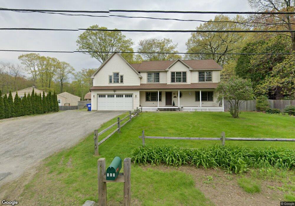
186 Delay Rd Harwinton, CT 06791
Estimated Value: $460,000 - $473,000
3
Beds
3
Baths
1,900
Sq Ft
$246/Sq Ft
Est. Value
About This Home
This home is located at 186 Delay Rd, Harwinton, CT 06791 and is currently estimated at $466,455, approximately $245 per square foot. 186 Delay Rd is a home located in Litchfield County with nearby schools including Harwinton Consolidated School, Har-Bur Middle School, and Lewis S. Mills High School.
Ownership History
Date
Name
Owned For
Owner Type
Purchase Details
Closed on
May 12, 2000
Sold by
Est Desrochers Ruth and Desrochers David
Bought by
Gervais Christopher M and Gervais Emily M
Current Estimated Value
Home Financials for this Owner
Home Financials are based on the most recent Mortgage that was taken out on this home.
Original Mortgage
$84,000
Interest Rate
8.21%
Create a Home Valuation Report for This Property
The Home Valuation Report is an in-depth analysis detailing your home's value as well as a comparison with similar homes in the area
Home Values in the Area
Average Home Value in this Area
Purchase History
| Date | Buyer | Sale Price | Title Company |
|---|---|---|---|
| Gervais Christopher M | $105,000 | -- | |
| Gervais Christopher M | $105,000 | -- |
Source: Public Records
Mortgage History
| Date | Status | Borrower | Loan Amount |
|---|---|---|---|
| Open | Gervais Christopher M | $163,000 | |
| Closed | Gervais Christopher M | $164,000 | |
| Closed | Gervais Christopher M | $86,000 | |
| Closed | Gervais Christopher M | $84,000 |
Source: Public Records
Tax History
| Year | Tax Paid | Tax Assessment Tax Assessment Total Assessment is a certain percentage of the fair market value that is determined by local assessors to be the total taxable value of land and additions on the property. | Land | Improvement |
|---|---|---|---|---|
| 2025 | $6,668 | $289,900 | $50,940 | $238,960 |
| 2024 | $6,639 | $289,900 | $50,940 | $238,960 |
| 2023 | $6,564 | $224,780 | $36,390 | $188,390 |
| 2022 | $6,406 | $224,780 | $36,390 | $188,390 |
| 2021 | $6,451 | $224,780 | $36,390 | $188,390 |
| 2020 | $6,294 | $224,780 | $36,390 | $188,390 |
| 2019 | $6,294 | $224,780 | $36,390 | $188,390 |
| 2018 | $6,075 | $216,980 | $35,640 | $181,340 |
| 2017 | $6,032 | $216,980 | $35,640 | $181,340 |
| 2016 | $6,032 | $216,980 | $35,640 | $181,340 |
| 2015 | $5,924 | $216,980 | $35,640 | $181,340 |
| 2014 | $5,837 | $216,980 | $35,640 | $181,340 |
Source: Public Records
Map
Nearby Homes
- 111 Whetstone Rd
- Lot 2 Birch Hill Rd
- Lot 3A William Way
- 399 Hill Rd
- 0 Clearview Ave Unit 24158105
- 184 Campville Hill Rd
- 67 E Litchfield Rd S
- 152 Davis Rd
- 0 Decker Dr Unit 24148478
- 604 Wildcat Hill Rd
- 68 Thomaston Rd
- 164 Birge Park Rd
- 151 Highview Dr
- 0 Reder Rd Unit 24133780
- 35 Quail Run
- 3 Break Maiden Ln
- 3 & 5 Break Maiden Ln
- 505 Harwinton Ave Unit 20
- 7 Wilson Pond Rd
- 185 Oak Meadow Ln
- 190 Delay Rd
- 181 Delay Rd
- 180 Delay Rd
- 189 Delay Rd
- 176 Delay Rd
- 194 Delay Rd
- 202 Delay Rd
- 206 Delay Rd
- 198 Delay Rd
- 210 Delay Rd
- 164 Delay Rd
- 220 Delay Rd
- 172 Delay Rd
- 153 Delay Rd
- 168 Delay Rd
- 145 Delay Rd
- 202 Wildcat Hill Rd
- 0 Wildcat Hill Road and Delay Rd Unit L126847
- 190 Wildcat Hill Rd
- 191 Wildcat Hill Rd
Your Personal Tour Guide
Ask me questions while you tour the home.