188 Captains Row Bourne, MA 2532
Estimated Value: $914,000 - $1,403,217
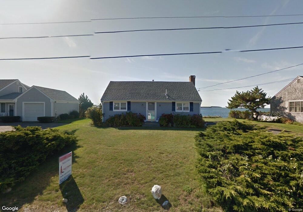
About This Home
This home is located at 188 Captains Row, Bourne, MA 2532 and is currently estimated at $1,212,804, approximately $1,403 per square foot. 188 Captains Row is a home located in Barnstable County with nearby schools including Bourne High School.
Ownership History
We collect this data history from publicly available records. To have your information removed, we recommend requesting removal directly through your county’s website.
Purchase Details
Home Financials for this Owner
Home Financials are based on the most recent Mortgage that was taken out on this home.Purchase History
We collect this data history from publicly available records. To have your information removed, we recommend requesting removal directly through your county’s website.
| Date | Buyer | Sale Price | Title Company |
|---|---|---|---|
| $600,000 | -- | ||
| $600,000 | -- |
Mortgage History
We collect this data history from publicly available records. To have your information removed, we recommend requesting removal directly through your county’s website.
| Date | Status | Borrower | Loan Amount |
|---|---|---|---|
| Open | $300,000 | ||
| Closed | $300,000 |
Tax History
We collect this data history from publicly available records. To have your information removed, we recommend requesting removal directly through your county’s website.
| Year | Tax Paid | Tax Assessment Tax Assessment Total Assessment is a certain percentage of the fair market value that is determined by local assessors to be the total taxable value of land and additions on the property. | Land | Improvement |
|---|---|---|---|---|
| 2025 | $9,612 | $1,230,700 | $1,006,400 | $224,300 |
| 2024 | $9,168 | $1,143,100 | $958,400 | $184,700 |
| 2023 | $8,639 | $980,600 | $848,200 | $132,400 |
| 2022 | $8,551 | $847,500 | $750,600 | $96,900 |
| 2021 | $8,307 | $771,300 | $683,100 | $88,200 |
| 2020 | $3,070 | $760,100 | $676,600 | $83,500 |
| 2019 | $3,144 | $756,500 | $676,600 | $79,900 |
| 2018 | $2,920 | $716,800 | $644,500 | $72,300 |
| 2017 | $7,374 | $715,900 | $638,400 | $77,500 |
| 2016 | $7,500 | $738,200 | $673,800 | $64,400 |
| 2015 | $7,472 | $742,000 | $673,800 | $68,200 |
Map
- 36 Starboard Rd Unit D
- 566 Shore Rd
- 455 Shore Rd
- 455 Shore Rd
- 443 Shore Rd
- 4 Evergreen Hill Rd
- 8 Sherry Ln
- 8 Sherry Ln
- 14 Navajo Rd
- 35 Benedict Rd
- 17 Old Colony Ave
- 1 Boat House Dr
- 770 Shore Rd
- 47 Cliff Rd
- 10 Howard Ave
- 4 Cross Rd
- 30 Seabreeze Dr
- 12 Groveland St
- 40 Bennets Neck Dr
- 446 Barlows Landing Rd
- 182 Leeward Rd
- 180 Leeward Rd
- 184 Captains Row
- 180 Leeward Rd
- 183 Clipper Rd
- 149 Leeward Rd
- 0 Leeward Rd Unit 71227280
- 181 Clipper Rd
- 185 Captains Row
- 149 Leeward Rd
- 147 Leeward Rd
- 147 Leeward Rd
- 178 Leeward Rd
- 186 Captains Row
- 179 Clipper Rd
- 187 Captains Row
- 179 Clipper Rd
- 145 Leeward Rd
- 153 Captains Row
- 208 Clipper Rd
Ask me questions while you tour the home.