NOT LISTED FOR SALE

188 Poor Farm Rd Vinalhaven, ME 04863

14 Acres
-- Price per Acre
609,840 Sq Ft Lot

Last Sold July 09, 2020

Last sale price $385,000

277 Days on Market

Highlights

  • 500 Feet of Waterfront
  • Wooded Lot
  • Pasture
  • Property Near A Cove
  • No HOA
  • Open Lot

About This Lot

As of July 2020

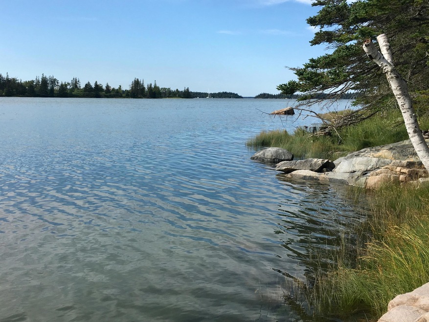
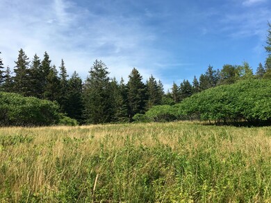
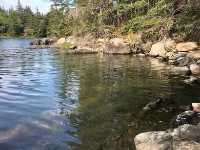
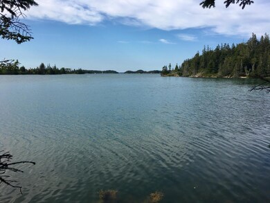
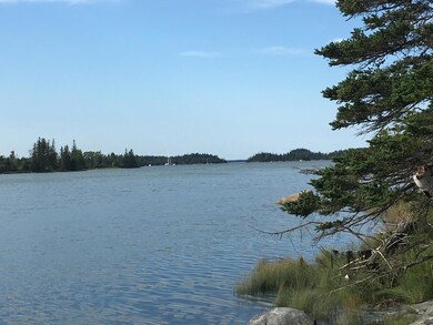
A rare opportunity to own a large undeveloped parcel of land on upper Smith Cove, just off Seal Bay and Isle Au Haut Bay. The 14 acres include a sloping open field, mix of soft and hardwood trees, a walking trail along the shore, and old stone walls. Partial driveway completed. The land is currently owned by MCHT and will transfer with a modest conservation easement. A private and pristine area of Vinalhaven, with lovely waterfront and views. Very special.

Last Agent to Sell the Property

Kristine Davidson

Davidson Realty Listed on: 06/18/2019

Last Buyer's Agent

Kristine Davidson

Davidson Realty Listed on: 06/18/2019

Property Details

Property Type

  • Land

Est. Annual Taxes

  • $5,212

Lot Details

  • 14 Acre Lot
  • 500 Feet of Waterfront
  • Ocean Front
  • Property fronts a private road
  • Dirt Road
  • Near Conservation Area
  • Rural Setting
  • Open Lot
  • Lot Has A Rolling Slope
  • Wooded Lot
  • Property is zoned RM-3

Property Views

  • Water
  • Scenic Vista
  • Woods

Farming

  • Pasture

Utilities

  • Electricity Not Available
  • Natural Gas Not Available
  • Water Not Available
  • Well Required
  • Perc Test On File For Septic Tank
  • Sewer Not Available

Listing and Financial Details

  • Tax Lot 32
  • Assessor Parcel Number VINA-000007-000000-000032

Community Details

Overview

  • No Home Owners Association
  • The community has rules related to deed restrictions

Recreation

  • Property Near A Cove

Property Details

Property Type

Land

Est. Annual Taxes

$5,212

Lot Details

0

Listing Details

  • Prop. Type: Land
  • Lot Size Acres: 14.0
  • Road Frontage Type: Private
  • Road Surface Type: Gravel
  • Water Body Name: Smith Cove/Seal Bay
  • MLS Status: Closed
  • Directions: From ferry head east toward Main Street and continue onto East Main St. which becomes Pequot Rd and then Coombs Neck Rd. Take left onto Poor Farm Road. Driveway is on the right just past Stone Farm.
  • Property Information:Lot Size Acres -: 14.0
  • Site:Open: Yes
  • Water Info:Water Frontage2: Yes
  • Water Info:Water View2: Yes
  • Roads:Private: Yes
  • Gas:No Gas: Yes
  • Property Information:Short Sale Continue to Show: No
  • Location:Rural: Yes
  • Water Info:Waterfront Amount -: 500.0
  • Water Info:Water Frontage Owned -: 500.0
  • Site:Wooded: Yes
  • View:TreesWoods: Yes
  • Site:RollingSloping: Yes
  • Property Information:Deed Restrictions: Yes
  • Property Information:Bank Owned REO: No
  • View:Scenic: Yes
  • Property Information:Mobile Homes Allowed: Unknown
  • View:Fields: Yes
  • Electric:No Electric: Yes
  • Sewer:None4: Yes
  • Water:Well Needed on Site: Yes
  • Site:PastureField: Yes
  • Location:Abuts Conservation: Yes
  • Special Features: None
  • Property Sub Type: LotsLands

Exterior Features

  • Lot Features: Open Lot, Right of Way, Rolling Slope, Wooded, Abuts Conservation, Pasture, Near Town, Rural
  • View: Fields, Scenic, Trees/Woods
  • Waterfront Features: Cove, Ocean
  • Waterfront: Yes

Garage/Parking

  • Parking Features: 1 - 4 Spaces, Other

Utilities

  • Electric: No Electric
  • Sewer: None, Perc Test On File
  • Water Source: Well Needed on Site, None

Condo/Co-op/Association

  • Association: No

Lot Info

  • Lot Size Sq Ft: 609840.0
  • Parcel #: VINA-000007-000000-000032
  • Zoning: RM-3

Tax Info

  • Tax Annual Amount: 5212.0
  • Tax Book Number: 5270
  • Tax Lot: 32
  • Tax Map Number: 7
  • Tax Year: 2018

Ownership History

Date Name Owned For Owner Type

Purchase Details

Closed on
Mar 12, 2018
Sold by
Lasansky Maine T
Bought by
Conservation Limited Dev

Purchase Details

Closed on
Nov 22, 2013
Sold by
Lasansky Maine T
Bought by
Benne Stephen

Home Financials for this Owner

Home Financials are based on the most recent Mortgage that was taken out on this home.
Original Mortgage
$360,000
Interest Rate
4.61%
Mortgage Type
Commercial
Source: Public Records

Range of Values:

Collateral Analytics

Collateral Analytics Collateral Analytics AVMs (Automated Valuation Model) employ a number of statistical approaches combined with neighborhood-specific comparable selection guarantees the most up-to-date and precise valuations.

Not Available

Collateral Analytics does not have data for the current month. Please view the chart for historical values.

ICE

ICE Mortgage Technology ICE Mortgage Technology’s AVM (Automated Valuation Model) is a state-of-the-art online residential property valuation tool that provides a quick and accurate estimate of the value of almost any home in the U.S.

Not Available

ICE Mortgage Technology does not have data for the current month. Please view the chart for historical values.

First American

First American First American Data & Analytics’ next-generation AVM combines unrivaled data assets with a blended ensemble of valuation models to produce highly accurate, reliable valuations you can trust.

Not Available

First American does not have data for the current month. Please view the chart for historical values.

Quantarium

Quantarium Quantarium’s valuation service, repeatedly proven the industry’s most accurate and comprehensive, is supercharged with a self-learning and auto-tuning AI engine that continually becomes smarter and more accurate as it processes daily inputs from the industry’s leading RE data lake.

Not Available

Quantarium does not have data for the current month. Please view the chart for historical values.

Average Value
Not Available
List Price
Sold Price
Create a Home Valuation Report for This Property
The Home Valuation Report is an in-depth analysis detailing your home's value as well as a comparison with similar homes in the area

Home Values in the Area

Source: Public Records

Average Home Value in this Area


Source: Public Records

Purchase History

Date Buyer Sale Price Title Company
Conservation Limited Dev -- --
Benne Stephen -- --
Source: Public Records

Mortgage History

Date Status Borrower Loan Amount
Previous Owner Wiggin Bethany $360,000
Previous Owner Lasansky Maine T $15,000
Source: Public Records

Property History

Date Event Price Change Sq Ft Price
07/09/2020 07/09/20 Sold $385,000 0.0% --
03/22/2020 03/22/20 Pending -- -- --
06/18/2019 06/18/19 For Sale $385,000 -- --
Source: Maine Listings

Tax History Compared to Growth

Source: Public Records

Tax History

Year Tax Paid Tax Assessment Tax Assessment Total Assessment is a certain percentage of the fair market value that is determined by local assessors to be the total taxable value of land and additions on the property. Land Improvement
2024 $3,693 $286,300 $286,300 $0
2023 $3,521 $286,300 $286,300 $0
2022 $7,275 $286,300 $286,300 $0
2021 $6,481 $216,600 $216,600 $0
2020 $6,428 $424,800 $424,800 $0
2019 $6,069 $424,800 $424,800 $0
2018 $5,787 $424,800 $424,800 $0
2017 $5,554 $440,000 $440,000 $0
2016 $5,651 $442,200 $442,200 $0
2015 $4,493 $442,200 $442,200 $0
2014 $2,264 $227,500 $227,500 $0
Source: Public Records

Agents Affiliated with this Home

  • Section Image
See All Agents

Map

Source: Maine Listings

MLS Number: 1420335

Maine Listings

APN: VINA-000007-000000-000032